Gmina Wołczyn is an urban-rural gmina in Kluczbork County, Opole Voivodeship, in south-western Poland. Its seat is the town of Wołczyn, which lies approximately 12 kilometres (7 mi) west of Kluczbork and 40 km (25 mi) north of the regional capital Opole.

Ligota Wielka is a village in the administrative district of Gmina Pawłowiczki, within Kędzierzyn-Koźle County, Opole Voivodeship, in south-western Poland. It lies approximately 4 kilometres (2 mi) north-west of Pawłowiczki, 15 km (9 mi) south-west of Kędzierzyn-Koźle, and 44 km (27 mi) south of the regional capital Opole.
Bażany is a village in the administrative district of Gmina Kluczbork, within Kluczbork County, Opole Voivodeship, in south-western Poland. It lies approximately 15 kilometres (9 mi) south of Kluczbork and 27 km (17 mi) north-east of the regional capital Opole.
Bogacica is a village in the administrative district of Gmina Kluczbork, within Kluczbork County, Opole Voivodeship, in south-western Poland. It lies approximately 6 kilometres (4 mi) west of Kluczbork and 37 km (23 mi) north-east of the regional capital Opole.
Borkowice is a village in the administrative district of Gmina Kluczbork, within Kluczbork County, Opole Voivodeship, in south-western Poland. It lies approximately 7 kilometres (4 mi) south-west of Kluczbork and 35 km (22 mi) north-east of the regional capital Opole.
Krasków is a village in the administrative district of Gmina Kluczbork, within Kluczbork County, Opole Voivodeship, in south-western Poland. It lies approximately 4 kilometres (2 mi) south-west of Kluczbork and 38 km (24 mi) north-east of the regional capital Opole.
Kuniów is a village in the administrative district of Gmina Kluczbork, within Kluczbork County, Opole Voivodeship, in south-western Poland. It lies approximately 5 kilometres (3 mi) south of Kluczbork and 38 km (24 mi) north-east of the regional capital Opole.

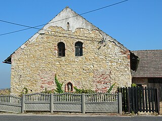
Ligota Górna is a village in the administrative district of Gmina Kluczbork, within Kluczbork County, Opole Voivodeship, in south-western Poland.
Ligota Zamecka is a village in the administrative district of Gmina Kluczbork, within Kluczbork County, Opole Voivodeship, in south-western Poland. It lies approximately 3 kilometres (2 mi) south-east of Kluczbork and 40 km (25 mi) north-east of the regional capital Opole.
Smardy Górne is a village in the administrative district of Gmina Kluczbork, within Kluczbork County, Opole Voivodeship, in south-western Poland. It lies approximately 4 kilometres (2 mi) north-west of Kluczbork and 41 km (25 mi) north-east of the regional capital Opole.
Żabiniec is a village in the administrative district of Gmina Kluczbork, within Kluczbork County, Opole Voivodeship, in south-western Poland. It lies approximately 8 kilometres (5 mi) south-west of Kluczbork and 35 km (22 mi) north-east of the regional capital Opole.
Trzebiszyn is a village in the administrative district of Gmina Lasowice Wielkie, within Kluczbork County, Opole Voivodeship, in south-western Poland. It lies approximately 4 kilometres (2 mi) south-west of Lasowice Wielkie, 15 km (9 mi) south of Kluczbork, and 27 km (17 mi) north-east of the regional capital Opole.
Gierałcice is a village in the administrative district of Gmina Wołczyn, within Kluczbork County, Opole Voivodeship, in south-western Poland. It lies approximately 4 kilometres (2 mi) south of Wołczyn, 12 km (7 mi) west of Kluczbork, and 37 km (23 mi) north of the regional capital Opole.
Ligota Wołczyńska is a village in the administrative district of Gmina Wołczyn, within Kluczbork County, Opole Voivodeship, in south-western Poland.
Wąsice is a village in the administrative district of Gmina Wołczyn, within Kluczbork County, Opole Voivodeship, in south-western Poland. It lies approximately 5 kilometres (3 mi) south-west of Wołczyn, 14 km (9 mi) west of Kluczbork, and 36 km (22 mi) north of the regional capital Opole.
Wierzbica Dolna is a village in the administrative district of Gmina Wołczyn, within Kluczbork County, Opole Voivodeship, in south-western Poland.
Ligota Dobrodzieńska is a village in the administrative district of Gmina Dobrodzień, within Olesno County, Opole Voivodeship, in south-western Poland. It lies approximately 4 kilometres (2 mi) west of Dobrodzień, 16 km (10 mi) south of Olesno, and 34 km (21 mi) east of the regional capital Opole.
Ligota Dolna, is a village in the administrative district of Gmina Strzelce Opolskie, within Strzelce County, Opole Voivodeship, in south-western Poland. It lies approximately 12 kilometres (7 mi) west of Strzelce Opolskie and 25 km (16 mi) south-east of the regional capital Opole.
Ligota Górna is a village in the administrative district of Gmina Strzelce Opolskie, within Strzelce County, Opole Voivodeship, in south-western Poland. It lies approximately 10 kilometres (6 mi) west of Strzelce Opolskie and 26 km (16 mi) south-east of the regional capital Opole.


