
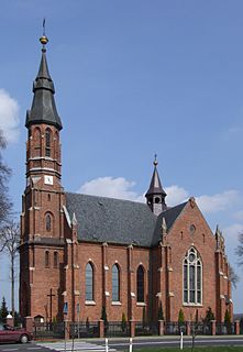
Wędrynia is a village in the administrative district of Gmina Lasowice Wielkie, within Kluczbork County, Opole Voivodeship, in south-western Poland. It lies approximately 15 kilometres (9 mi) south-east of Kluczbork and 35 km (22 mi) north-east of the regional capital Opole.
Gmina Lasowice Wielkie, German Gemeinde Gross Lassowitz is a rural gmina in Kluczbork County, Opole Voivodeship, in south-western Poland. Its seat is the village of Lasowice Wielkie, which lies approximately 13 kilometres (8 mi) south of Kluczbork and 31 km (19 mi) north-east of the regional capital Opole.
Bąków is a village in the administrative district of Gmina Kluczbork, within Kluczbork County, Opole Voivodeship, in south-western Poland. It lies approximately 8 kilometres (5 mi) east of Kluczbork and 43 km (27 mi) north-east of the regional capital Opole.
Bażany is a village in the administrative district of Gmina Kluczbork, within Kluczbork County, Opole Voivodeship, in south-western Poland. It lies approximately 15 kilometres (9 mi) south of Kluczbork and 27 km (17 mi) north-east of the regional capital Opole.
Bogacica is a village in the administrative district of Gmina Kluczbork, within Kluczbork County, Opole Voivodeship, in south-western Poland. It lies approximately 6 kilometres (4 mi) west of Kluczbork and 37 km (23 mi) north-east of the regional capital Opole.
Krasków is a village in the administrative district of Gmina Kluczbork, within Kluczbork County, Opole Voivodeship, in south-western Poland. It lies approximately 4 kilometres (2 mi) south-west of Kluczbork and 38 km (24 mi) north-east of the regional capital Opole.
Kuniów is a village in the administrative district of Gmina Kluczbork, within Kluczbork County, Opole Voivodeship, in south-western Poland. It lies approximately 5 kilometres (3 mi) south of Kluczbork and 38 km (24 mi) north-east of the regional capital Opole.
Ligota Dolna is a village in the administrative district of Gmina Kluczbork, within Kluczbork County, Opole Voivodeship, in south-western Poland. It lies approximately 4 kilometres (2 mi) south-west of Kluczbork and 38 km (24 mi) north-east of the regional capital Opole.
Ligota Zamecka is a village in the administrative district of Gmina Kluczbork, within Kluczbork County, Opole Voivodeship, in south-western Poland. It lies approximately 3 kilometres (2 mi) south-east of Kluczbork and 40 km (25 mi) north-east of the regional capital Opole.
Żabiniec is a village in the administrative district of Gmina Kluczbork, within Kluczbork County, Opole Voivodeship, in south-western Poland. It lies approximately 8 kilometres (5 mi) south-west of Kluczbork and 35 km (22 mi) north-east of the regional capital Opole.
Kochłowice is a village in the administrative district of Gmina Byczyna, within Kluczbork County, Opole Voivodeship, in south-western Poland. It lies approximately 5 kilometres (3 mi) south-west of Byczyna, 12 km (7 mi) north of Kluczbork, and 50 km (31 mi) north of the regional capital Opole.

Chocianowice is a village in the administrative district of Gmina Lasowice Wielkie, within Kluczbork County, Opole Voivodeship, in south-western Poland. It lies approximately 8 kilometres (5 mi) south-east of Kluczbork and 39 km (24 mi) north-east of the regional capital Opole.
Chudoba is a village in the administrative district of Gmina Lasowice Wielkie, within Kluczbork County, Opole Voivodeship, in south-western Poland. It lies approximately 16 kilometres (10 mi) south of Kluczbork and 32 km (20 mi) north-east of the regional capital Opole.
Jasienie is a village in the administrative district of Gmina Lasowice Wielkie, within Kluczbork County, Opole Voivodeship, in south-western Poland. It lies approximately 4 kilometres (2 mi) north of Lasowice Wielkie, 10 km (6 mi) south of Kluczbork, and 33 km (21 mi) north-east of the regional capital Opole.

Lasowice Małe is a village in the administrative district of Gmina Lasowice Wielkie, within Kluczbork County, Opole Voivodeship, in south-western Poland. It lies approximately 10 kilometres (6 mi) south of Kluczbork and 36 km (22 mi) north-east of the regional capital Opole.
Szumirad is a village in the administrative district of Gmina Lasowice Wielkie, within Kluczbork County, Opole Voivodeship, in south-western Poland. It lies approximately 17 kilometres (11 mi) south of Kluczbork and 29 km (18 mi) north-east of the regional capital Opole.
Gierałcice is a village in the administrative district of Gmina Wołczyn, within Kluczbork County, Opole Voivodeship, in south-western Poland. It lies approximately 4 kilometres (2 mi) south of Wołczyn, 12 km (7 mi) west of Kluczbork, and 37 km (23 mi) north of the regional capital Opole.
Szum is a village in the administrative district of Gmina Wołczyn, within Kluczbork County, Opole Voivodeship, in south-western Poland. It lies approximately 7 kilometres (4 mi) south-west of Wołczyn, 15 km (9 mi) west of Kluczbork, and 35 km (22 mi) north of the regional capital Opole.
Wąsice is a village in the administrative district of Gmina Wołczyn, within Kluczbork County, Opole Voivodeship, in south-western Poland. It lies approximately 5 kilometres (3 mi) south-west of Wołczyn, 14 km (9 mi) west of Kluczbork, and 36 km (22 mi) north of the regional capital Opole.
Niwki is a village in the administrative district of Gmina Strzelce Opolskie, within Strzelce County, Opole Voivodeship, in south-western Poland. It lies approximately 9 kilometres (6 mi) west of Strzelce Opolskie and 25 km (16 mi) south-east of the regional capital Opole.


