
Bhojpur is one of the two urban municipalities of Bhojpur District of Province No. 1 of Nepal.
Khanchikot is a market center in Sandhikharka Municipality of Arghakhanchi District. The district lies in the Lumbini Zone of Western Nepal. The former village development committee (VDC) was converted into municipality on 18 May 2014 by merging the existing Sandhikharka, Bangla, Narapani, Khanchikot, Keemadada, Argha and Dibharna VDCs. During 1991 Nepal census it was estimated to have a total population of 4,628 individuals and had 930 houses.
Dhanushadham is a municipality in Dhanusha District in Province No. 2 of south-eastern Nepal. The municipality was established on 18 May 2014 by merging the existing Govindapur, Umprempur, Yagyabhumi, Dhanushadham village development committees (VDCs). It is a religious place of Hindu worship in Nepal. It is believed that a part of Shiva Dhanusha that was broken by Rama during Sita's swayamvara, is housed. Now there is temple around the remaining of bow and visited by Hindu devotees from all over the world. That's why it is named Dhanushadham.

Chandannath is a municipality in Jumla District in the Karnali Province of Nepal. The municipality was established on 18 May 2014 by merging the existing Mahat Gaun, Talium, Kartik Swami (Jumla), and Chandannath village development committees (VDCs). At the time of the 1991 Nepal census it had a population of 5,842 persons living in 1,000 individual households.

Aamtep is a former VDC and now a neighborhood of Bhojpur Municipality in Bhojpur District in the Province No. 1 of eastern Nepal. At the time of the 1991 Nepal census it had a population of 3,136 persons living in 537 individual households.
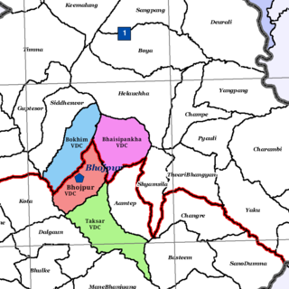
Bhaisipankha is a former VDC and now a neighborhood of Bhojpur Municipality in Bhojpur District in the Province No. 1 of eastern Nepal. At the time of the 1991 Nepal census it had a population of 3,077 persons living in 555 individual households.
Taksar is a former VDC and now a neighborhood of Bhojpur Municipality in Bhojpur District in Province No. 1 of eastern Nepal. At the time of the 1991 Nepal census, Taksar had a population of 4,524 persons living in 829 individual households.

Nijgadh, is a town and municipality in Nepal, located in Bara District of the Madhesh Province. The municipality was formed in May 2014 by merging Nijgadh VDC with Ratnapuri VDC and Bharatganj Singaul VDC. According to the preliminary report of 2021 Nepalese census, the population of the municipality is 36,491, the fifth highest in the district. It is located 135 kilometres (84 mi) south of the capital, Kathmandu, and 31 kilometres (19 mi) north of the district headquarter, Kalaiya. The Mahendra highway runs through the municipality. The nearest domestic airport, Simara Airport, is 24 kilometres (15 mi) away from the town.
Chapakot is a municipality in the southeastern part of Syangja District in Gandaki Province of central Nepal. The new municipality was formed by merging three existing villages—Ratnapur, Kuwakot and Chapakot—on 18 May 2014. In 12 March 2017 The government implemented the new local administrative structure consisting of 744 local units. With the implementation of this new local administrative structure, the old structure will no longer be in existence. According to the new structure, VDCs will be replaced with village councils. Newly merged VDCs are Sankhar, Sekham, Ward no. 8 of Pakbadi & Ward no. of Malyangkot. The office of the municipality is that of the former Chapakot Municipality.

Melung is a Rural municipality located within the Dolakha District of the Bagmati Province of Nepal. The municipality spans 86.54 square kilometres (33.41 sq mi) of area, with a total population of 20,210 according to a 2011 Nepal census.
Ishworpur is a Municipality in Sarlahi District in the Janakpur Zone of south-eastern Nepal. The municipality was established on 18 May 2014 by merging the existing Bela, Bhaktipur, Gaurishankar and Ishwarpur VDCs. At the time of the 1991 Nepal census it had a population of 14,014 people living in 249 individual households.
Khoksar Parbaha is a market center and town in Shambhunath Municipality in Saptari District in the Sagarmatha Zone of south-eastern Nepal. The Khoksar Parbaha village development committee (VDC) was merged with Shambhunath, Mohanpur, Bhangaha, Basbalpur and Rampur Jamuwa VDCs to form a new municipality on 18 May 2014. At the time of the 1991 Nepal census, Khoksar Parbaha had a population of 2,964 people and 534 individual households. Khoksar Parbaha is bordered by Shambhunath and Terahauta.

Pakhribas is an urban municipality out of three urban municipalities located in Dhankuta District of Province No. 1 of Nepal. Pakhribas municipality established on 2 December 2014 merging following VDCs: Pakhribas, Sanne, Phalate, Ghorlikharka and Muga.
Dudharakchhe is a town in Sainamaina Municipality in Rupandehi District in Lumbini Province of southern Nepal. The former VDC was merged to establish the new municipality on 18 May 2014 with the two existing VDCs i.e. Dudharakchhe and Parroha. At the time of the 1991 Nepal census it had a population of 10,684 people living in 1952 individual households.
Parroha is a town in Sainamaina Municipality in Rupandehi District in Lumbini Province of southern Nepal. The former VDC was merged to established new municipality on 18 May 2014 with the two existing VDCs i.e. Dudharakchhe and Parroha. At the time of the 1991 Nepal census it had a population of 12,493 people living in 2165 individual households.
Gunjanagar is a town in Bharatpur, Chitwan in Bagmati Province of southern Nepal. The former Gunjanagar VDC and Saradanagar VDC were merged on 18 May 2014 to form new Chitrawan Municipality, which later was merged with Bharatpur. At the time of the 1991 Nepal census it had a population of 11,076 people living in 2025 individual households.
Shivanagar is a town in Krishnanagar Municipality in Kapilvastu District in the Lumbini Zone of southern Nepal. The former VDC was merged to form the municipality established on 18 May 2014 Krishnanagar, Sirsihawa, Shivanagar VDCs. At the time of the 2011 Nepal census it had a population of 4,774 people living in 735 individual households.
Pathari Shanishchare (पथरी-शनिश्चरे) is a Municipality in Morang District in the Koshi Zone of south-eastern Nepal. It was formed by merging three existing village development committees i.e. Hasandaha, Pathari and Sanischare in May 2014.
Sundar Haraicha is a municipality in Morang District of Province No. 1 in Nepal. It is centered around Biratchowk town which is the gateway to Biratnagar. It borders Itahari Sub- Metropolitan city to the West, Dharan Sub- Metropolitan city to the Northwest and Belbari municipality to the East and is connected by the Mahendra Highway. It is one of the fastest growing cities in the Eastern Nepal and the second largest city of Morang district after Biratnagar with 121,305 inhabitants living in 26,677 households. It consists the town centres of Biratchowk and Gothgaun which are parts of the Greater Birat Development Area which incorporates the cities of Biratnagar-Itahari-Gothgau-Biratchowk-Dharan primarily located on the Koshi Highway in Eastern Nepal, with an estimated total urban agglomerated population of 804,300 people living in 159,332 households.
Bhojpur is a neighborhood in Bhojpur Municipality which is located in Bhojpur District in Province No. 1 of Nepal. The Bhojpur Village Panchayat was established in 1962 and was renamed as Bhojpur Village development committee in 1990.


