| Designations | |
|---|---|
| Designated | 18 February 1982 |
| Reference no. | 231 [1] |

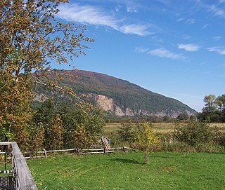
The Bolle di Magadino is a 1500-ha Swiss natural reserve. It is located by the confluence of the Ticino with Lake Maggiore. It is a biotope where birds nest and stop during migrations.
| Designations | |
|---|---|
| Designated | 18 February 1982 |
| Reference no. | 231 [1] |
The Bolle di Magadino is a 1500-ha Swiss natural reserve. It is located by the confluence of the Ticino with Lake Maggiore. It is a biotope where birds nest and stop during migrations.
Starting from 1888 the track of the Ticino river has been modified where it flows into the lake. Banks were built in 1908, and the reclamation of the Magadino area started in 1918. In 1924 dams were built in order to regulate the river. During World War II there lands have been cultivated.
After the war the terrains have been reclaimed and in 1965 the dam for the Verzasca River was completed.
After these works the vegetation of the area has changed. Since 1975 the site is run by the Bolle di Magadino foundation. In 1979 the area became cantonal reserve. In 1982 it has been enlisted in the UNESCO's Ramsar Convention for the protection of the moist areas. It has also been identified by BirdLife International as an Important Bird Area.
A research center for migratory birds has been created in 1994. It is part of the European project European-African Songbird Migration Network of the Oldenburg University. Thanks to these studies has been discovered the importance of the Bolle di Magadino for migratory birds. [2]

The river Ticino is the most important perennial left-bank tributary of the Po. It has given its name to the Swiss canton through which its upper portion flows.
The Cap Tourmente National Wildlife Area is a National Wildlife Area (NWA) located on the north shore of the Saint Lawrence River in the National Provincial Capital Region of Quebec, established on 28 April 1978. It is one of the critical habitats for the greater snow goose during migration. Flocks of tens of thousands of these birds stop over to feed on the bullrushes in the spring and fall. The tidal marsh was recognized as a wetland of international significance per the Ramsar Convention in 1981, the first North American site to receive that distinction.
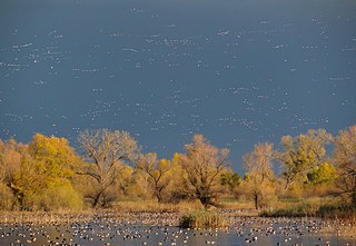
A flyway is a flight path used by large numbers of birds while migrating between their breeding grounds and their overwintering quarters. Flyways generally span continents and often pass over oceans. Although applying to any species of migrating bird, the concept was first conceived and applied to waterfowl and shore birds. The flyways can be thought of as wide arterial highways to which the migratory routes of different species are tributaries. An alternative definition is that a flyway is the entire range of a migratory bird, encompassing both its breeding and non-breeding grounds, and the resting and feeding locations it uses while migrating. There are four major north–south flyways in North America and six covering Eurasia, Africa, and Australasia.

Lake Hāmūn, or the Hamoun Oasis, is a seasonal lake and wetlands in the endorheic Sīstān Basin in the Sistan region on the Afghanistan–Iran border. In Iran, it is also known as Hāmūn-e Helmand, Hāmūn-e Hīrmand, or Daryāche-ye Sīstān.

The Asan Barrage is a barrage in the Uttarakhand-Himachal Pradesh border region in Doon Valley,, northern India, situated at the confluence of the Eastern Yamuna Canal and the Asan River and about 11 km (7 mi) from Dakpathar, and 28 km. northwest of Dehradun in Uttarakhand. The barrage is 287.5m long and has water throughout the year which is fed from the river Asan and the discharge channel of the river Yamuna. Since 2020 it has been declared as Uttarakhand's first Ramsar site.

Horicon Marsh is a marsh located in northern Dodge and southern Fond du Lac counties of Wisconsin. It is the site of both a national and a state wildlife refuge.

Hutovo Blato is a nature reserve and bird reserve located in Bosnia and Herzegovina. It is primarily composed of marshlands that were created by the underground aquifer system of the Krupa River. It is fed from the limestone massif of Ostrvo that divides the Deransko Lake and Svitavsko Lake. The reserve is on the list of BirdLife International's Important Bird Areas. It is the largest reserve of its kind in the region, in terms of both size and diversity. It is home to over 240 types of migratory birds and dozens that make their permanent home in the sub-Mediterranean wetlands surrounding Deransko Lake. In the migration season, tens of thousands of birds fill the lake and its surroundings.

Magadino is a former municipality in the district of Locarno in the canton of Ticino in Switzerland.

Maharana Pratap Sagar, also known as Pong Reservoir or Pong Dam Lake is a large reservoir in Fatehpur, Jawali and Dehra tehsil of Kangra district of the state of Himachal Pradesh in India. It was created in 1975, by building the highest earthfill dam in India on the Beas River in the wetland zone of the Siwalik Hills. Named in the honour of Maharana Pratap (1540–1597), the reservoir or the lake is a well-known wildlife sanctuary and one of the 49 international wetland sites declared in India by the Ramsar Convention. The reservoir covers an area of 24,529 hectares, and the wetlands portion is 15,662 hectares.

Gavkhouni also written as Gawkhuni or Batlaq-e-Gavkhuni, located in the Iranian Plateau in central Iran, east of the city of Isfahan, is the terminal basin of the Zayandeh River. Gavkhouni is a salt marsh with a salinity of 31.5% and an average depth of about 1 m. The salt marsh can dry up in summer. The Zayandeh River originates in the Zagros mountains, and travels around 300 km, before terminating in Gavkhouni.

The Quill Lakes are a wetland complex in Saskatchewan, Canada that encompasses the endorheic basin of three distinct lake wetlands: Big Quill Lake, Middle Quill Lake, and Little Quill Lake. On May 27, 1987, it was designated a wetland of international importance via the Ramsar Convention. It was the first Canadian site in the North American Waterfowl Management Plan, is a site in the International Biological Programme and Saskatchewan Heritage Marsh Program, and was designated a Western Hemisphere Shorebird Reserve Network site of International significance in May, 1994. The site is an important staging and breeding area for spring and fall migration of shorebirds. The site qualifies as an Important Bird Area (IBA) of Canada for its globally and nationally significant migratory and breeding populations of more than a dozen species of birds. The IBA is designated as Quill Lakes .
Hay-Zama Lakes is a 586-square-kilometre (226 sq mi) inland wetland and wildland park in northwestern Alberta, Canada. It was designated a Ramsar wetland of international importance on May 24, 1982, and is recognized as an Important Bird Area. It "constitutes one of the most extensive sedge wetlands in western North America".

The nature conservation site Poda was declared a protected area in 1989 by the Bulgarian Ministry of Water and Environment. It was the first protected area in Bulgaria that is completely managed and maintained by a non-governmental organization, the Bulgarian Society for the Protection of Birds (BSPB). BSPB prepares and implements activities adopted by the Council of Minister's Management Plan, but receives its funding completely from entrance fees, souvenirs sold, and donations. Through this arrangement, it aims to be a sustainable model for nature conservation, environmental education, and eco-tourism.

Gambarogno is a municipality in the district of Locarno in the canton of Ticino in Switzerland. It was created on 25 April 2010 through the merger of the municipalities of Caviano, Contone, Gerra, Indemini, Magadino, Piazzogna, San Nazzaro, Sant'Abbondio and Vira.

Khijadiya Bird Sanctuary is a bird sanctuary located in Jamnagar district of Gujarat, India. About 300 species of migratory birds have been recorded here.
CoEur is a Christian devotional and hiking route in Italy and Switzerland. Its Italian subtitle, Nel cuore dei cammini d'Europa, translates as "In the heart of Europe's paths".
Last Mountain Lake Bird Sanctuary is a National Historic Site of Canada, located in the rural municipality of Last Mountain Valley No. 250 in Saskatchewan. The migratory bird sanctuary was the first established in North America. The 47.36 km2 (18.29 sq mi) area is within the Last Mountain Lake National Wildlife Area, an International Biological Program site, and includes adjacent uplands.
Parvati Arga Bird Sanctuary is situated in the Gonda District and about 45 Km. from Gonda at Mankapur-Nawabganj Road and Mankapur-Faizabad Railway Line in the state of Uttar Pradesh, India. The sanctuary is spread over an area of 1084.47 ha. The lake is naturally able to sustain resident birds throughout the year and migratory birds during winter season. It was a part of the Saryu River. As the river changed its flow path these lakes were left as its remains. Thus, both the lakes are oxbow lakes. Parvati Arga Bird Sanctuary was declared vide Government. Notification No. 1021/14-3-14/90 dated 23.05.1990. The sanctuary consists of two lakes i.e. Parvati and Arga situated about 1.5 Km. apart. Tikri Reserve Forest falling under jurisdiction of Gonda Forest Division is at about 1 Km. The nearest town is Wajeerganj which is at a distance of 12 km from the Sanctuary.
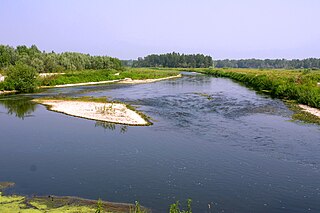
The Parco naturale lombardo della Valle del Ticino is a Nature reserve established on 9 January 1974. It was the first Italian regional park to be established and the first European river park. The park is located along the banks of the river Ticino, in Lombardy, in the provinces of Milan, Pavia and Varese, in an area of 91,410 hectares between Lake Maggiore and the Po. The park borders the Parco naturale della Valle del Ticino, located on the other side of the river in Piedmont, created in 1978. In 2022 the two Parks were included by UNESCO in the World Network of Biosphere Reserves.