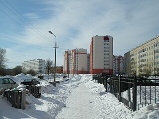
Gatchina is a town and the administrative center of Gatchinsky District in Leningrad Oblast, Russia. It lies 45 kilometers (28 mi) south-south-west of St. Petersburg, along the E95 highway which links Saint Petersburg and Pskov. Population: 92,937 (2010 Census); 88,420 (2002 Census); 79,714 (1989 Soviet census).

The Izhora, also known as the Inger, is a left tributary of the Neva on its run through Ingria in northwestern Russia from Lake Ladoga to the Gulf of Finland. The Izhora flows through Gatchinsky and Tosnensky Districts of Leningrad Oblast as well as through Pushkinsky and Kolpinsky Districts of the federal city of Saint Petersburg. The settlement of Ust-Izhora is situated at the confluence of Izhora and Neva, halfway between Saint Petersburg and Shlisselburg. The towns of Kommunar and Kolpino are located on the Izhora as well. The river is noted as the farthest Swedish forces ever reached between the Viking Age and the Time of Troubles.

Volosovo is a town and the administrative center of Volosovsky District in Leningrad Oblast, Russia, located on the railway between St. Petersburg and Tallinn, Estonia, 85 kilometers (53 mi) southwest from St. Petersburg. Population: 12,161 (2010 Census); 11,660 (2002 Census); 10,250 (1989 Soviet census).
Volosovsky District is an administrative and municipal district (raion), one of the seventeen in Leningrad Oblast, Russia. It is located in the southwest of the oblast with Lomonosovsky District in the north, Gatchinsky District in the east, Luzhsky District in the south, Slantsevsky District in the southwest, and Kingiseppsky District in the northwest. The area of the district is 2,700 square kilometers (1,000 sq mi). Its administrative center is the town of Volosovo. Population: 49,443 (2010 Census); 48,128 ; 46,908 (1989 Soviet census). The population of Volosovo accounts for 24.6% of the district's total population.
Krasny Bor is an urban locality in Tosnensky District of Leningrad Oblast, Russia, located 20 kilometers (12 mi) southeast of the center of St. Petersburg. Population: 5,033 (2010 Census); 4,877 (2002 Census); 5,791 (1989 Soviet census).
Tosno is a town and the administrative center of Tosnensky District in Leningrad Oblast, Russia, located on the Tosna River, 53 kilometers (33 mi) southeast of the center of St. Petersburg. Population: 39,101 (2010 Census); 38,683 (2002 Census); 32,459 (1989 Soviet census).

Nikolskoye is a town in Tosnensky District of Leningrad Oblast, Russia, located on the Tosna River 40 kilometers (25 mi) southeast of the center of St. Petersburg. Population: 19,280 (2010 Census); 17,309 (2002 Census); 17,215 (1989 Soviet census).
Kuznechnoye is an urban locality in the northern part of Priozersky District of Leningrad Oblast, located on the Karelian Isthmus. Population: 4,458 (2010 Census); 4,738 (2002 Census); 5,017 (1989 Soviet census).

Tosnensky District is an administrative and municipal district (raion), one of the seventeen in Leningrad Oblast, Russia. It is located in the central southwestern part of the oblast and borders with Kirovsky District in the north, Kirishsky District in the east, Chudovsky District of Novgorod Oblast in the southeast, Novgorodsky District of Novgorod Oblast in the south, Luzhsky District in the southwest, Gatchinsky District in the west, and Pushkinsky and Kolpinsky Districts of the federal city of Saint Petersburg in the northwest. The area of the district is 3,585.4 square kilometers (1,384.3 sq mi). Its administrative center is the town of Tosno. Population : 83,898 (2010 Census); 77,194 ; 78,500 (1989 Soviet census).
Kommunar is a town in Gatchinsky District of Leningrad Oblast, Russia, located on the banks of the Izhora River 35 kilometers (22 mi) south of the center of St. Petersburg. Population: 20,211 (2010 Census); 17,164 (2002 Census); 17,791 (1989 Soviet census). The name of the town means "Communards", in reference to supporters of the 1871 popular uprising in Paris.

Gatchinsky District is an administrative and municipal district (raion), one of the seventeen in Leningrad Oblast, Russia. It is located in the southwestern central part of the oblast and borders with Krasnoselsky, Moskovsky, and Pushkinsky Districts of the federal city of St. Petersburg in the north, Tosnensky District in the east, Luzhsky District in the south, Volosovsky District in the west, and with Lomonosovsky District in the northwest. The area of the district is 2,868.7 square kilometers (1,107.6 sq mi). Its administrative center is the town of Gatchina. Population : 140,210 (2010 Census); 132,010 ; 138,022 (1989 Soviet census).

Lebyazhye is an urban locality in Lomonosovsky District of Leningrad Oblast, Russia, located on the coast of the Gulf of Finland 25 kilometers (16 mi) west of Lomonosov and 30 kilometers (19 mi) east of Sosnovy Bor. Population: 4,729 (2010 Census); 5,600 (2002 Census); 5,340 (1989 Soviet census).

Ulyanovka is an urban locality in Tosnensky District of Leningrad Oblast, Russia, located approximately 40 kilometres (25 mi) southeast of the center of Saint Petersburg. Municipally it is incorporated as Ulyanovskoye Urban Settlement, one of the seven urban settlements in the district. Population: 11,601 (2010 Census); 9,244 (2002 Census); 9,595 (1989 Soviet census).

Lomonosovsky District is an administrative and municipal district (raion), one of the seventeen in Leningrad Oblast, Russia. It is located in the west of the oblast and borders with Petrodvortsovy and Krasnoselsky Districts of the Federal city of Saint Petersburg in the east, Gatchinsky District in the southeast, Volosovsky District in the south, Kingiseppsky District in the southwest, and the city of oblast significance of Sosnovy Bor in the west. In the north, the district is bounded by the Gulf of Finland. The area of the district is 1,919 square kilometers (741 sq mi). Its administrative center is the town of Lomonosov. Population: 70,245 (2010 Census); 65,297 ; 66,104 (1989 Soviet census).

Luzhsky District is an administrative and municipal district (raion), one of the seventeen in Leningrad Oblast, Russia. It is located in the southwest of the oblast and borders with Gatchinsky District in the north, Tosnensky District in the northeast, Novgorodsky and Batetsky Districts of Novgorod Oblast in the southeast, Shimsky District, also of Novgorod Oblast, in the south, Plyussky District of Pskov Oblast in the southwest, Slantsevsky District in the west, and Volosovsky District in the northwest. The area of the district is 6,006.44 square kilometers (2,319.10 sq mi). Its administrative center is the town of Luga. Population : 40,166 (2010 Census); 41,885 ; 48,721 (1989 Soviet census).

Lyubytinsky District is an administrative and municipal district (raion), one of the twenty-one in Novgorod Oblast, Russia. It is located in the northeast of the oblast and borders with Tikhvinsky District of Leningrad Oblast in the north, Boksitogorsky District of Leningrad Oblast in the northeast, Khvoyninsky District in the east, Borovichsky District in the southeast, Okulovsky District in the southwest, Malovishersky District in the west, and with Kirishsky District of Leningrad Oblast in the northwest. The area of the district is 4,500 square kilometers (1,700 sq mi). Its administrative center is the urban locality of Lyubytino. Population: 9,744 (2010 Census); 12,432 ; 15,263 (1989 Soviet census). The population of Lyubytino accounts for 28.8% of the district's total population.
Sheksninsky District is an administrative and municipal district (raion), one of the twenty-six in Vologda Oblast, Russia. It is located in the center of the oblast and borders with Kirillovsky District in the north, Vologodsky District in the east, Poshekhonsky District of Yaroslavl Oblast in the south, and with Cherepovetsky District in the west. The area of the district is 2,500 square kilometers (970 sq mi). Its administrative center is the urban locality of Sheksna. The district's population was 33,375 (2010 Census); 36,007 ; 34,679 (1989 Soviet census). The population of Sheksna accounts for 62.8% of the district's total population.
Druzhnaya Gorka is an urban locality in Gatchinsky District of Leningrad Oblast, Russia, located on the banks of the Orlinka River, south of the town of Gatchina. Population: 3,463 (2010 Census); 3,696 (2002 Census); 4,208 (1989 Soviet census).

Taytsy is an urban locality in Gatchinsky District of Leningrad Oblast, Russia, located north of the town of Gatchina. Population: 2,853 (2010 Census); 2,644 (2002 Census); 2,929 (1989 Soviet census). Taitsy is home to the Demidov Estate, a World Heritage Site.
Bolshaya Izhora is an urban locality in Lomonosovsky District of Leningrad Oblast, Russia, located on the southern shore of the Gulf of Finland. It is adjacent from the west to Saint Petersburg. Population: 3,314 (2010 Census); 3,831 (2002 Census); 3,967 (1989 Soviet census).