| Bondend | |
|---|---|
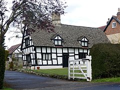 Bondend Farm | |
 Bondend Bondend shown within Gloucestershire | |
| OS grid reference | SO8615 |
| District | |
| Shire county | |
| Region | |
| Country | England |
| Sovereign state | United Kingdom |
| Police | Gloucestershire |
| Fire | Gloucestershire |
| Ambulance | South Western |
| EU Parliament | South West England |
Bondend is a lane within the village of Upton St Leonards in Gloucestershire, England.

Upton St Leonards is a village in the English county of Gloucestershire. Forming part of the district of Stroud, it is a mile or so north of the A46 road between Stroud and Cheltenham.

Gloucestershire is a county in South West England. The county comprises part of the Cotswold Hills, part of the flat fertile valley of the River Severn, and the entire Forest of Dean.