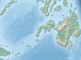
Zamboanga Peninsula is an administrative region in the Philippines, designated as Region IX. It consists of three provinces including four cities and the highly urbanized Zamboanga City. The region was previously known as Western Mindanao before the signing of Executive Order No. 36 of 2001. The city of Zamboanga was designated as the regional center until Pagadian was designated as its new regional center, although Zamboanga City remains the region's cultural, commercial, economic, and educational center.

Sulu, officially the Province of Sulu, is a province of the Philippines in the Sulu Archipelago and part of the Bangsamoro Autonomous Region in Muslim Mindanao (BARMM).

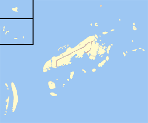
Tawi-Tawi, officially the Province of Tawi-Tawi, is an island province in the Philippines located in the Bangsamoro Autonomous Region in Muslim Mindanao (BARMM). The capital of Tawi-Tawi is Bongao.

South Cotabato, officially the Province of South Cotabato, is a province in the Philippines located in the Soccsksargen region in Mindanao. Its capital is Koronadal, and it borders Sultan Kudarat to the north and west, Sarangani to the south and northeast, and Davao del Sur to the far northeast. To the southeast lies Sarangani Bay.

The Autonomous Region in Muslim Mindanao was an autonomous region of the Philippines, located in the Mindanao island group of the Philippines, that consisted of five predominantly Muslim provinces: Basilan, Lanao del Sur, Maguindanao, Sulu, and Tawi-Tawi. It was the only region that had its own government. The region's de facto seat of government was Cotabato City, although this self-governing city was outside its jurisdiction.
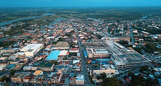
Cotabato City, officially the City of Cotabato, is a first class independent component city in the Bangsamoro Autonomous Region in Muslim Mindanao, Philippines. According to the 2020 census, it has a population of 325,079 people, making it as the most populated city under the independent component city status.

Isabela, officially the City of Isabela, is a 4th class component city and de facto capital of the province of Basilan, Philippines. According to the 2020 census, it has a population of 130,379 people making it the most populous city in the province.

Dipolog, officially the City of Dipolog, is a 3rd class component city and capital of the province of Zamboanga del Norte, Philippines. According to the 2020 census, it has a population of 138,141 people making it the most populous in the province.

Jolo, officially the Municipality of Jolo, is a 1st class municipality and capital of the province of Sulu, Philippines. According to the 2020 census, it has a population of 137,266 people.

Pagadian, officially the City of Pagadian, is a 1st class component city and the capital of the province of Zamboanga del Sur, Philippines. It is the regional center of Zamboanga Peninsula and the second-largest city in the region and in the province, after the independent city of Zamboanga. According to the 2020 census, it has a population of 210,452 people. The city will be converted to a highly urbanized city by the virtue of Proclamation No. 1247, signed by President Rodrigo Duterte dated November 8, 2021.

Bongao, officially the Municipality of Bongao, is a 2nd class municipality and capital of the province of Tawi-Tawi, Philippines. According to the 2020 census, it has a population of 116,118 people.
Mapun, officially the Municipality of Mapun, is a 4th class municipality in the province of Tawi-Tawi, Philippines. According to the 2020 census, it has a population of 30,038 people.

Tandubas, officially the Municipality of Tandubas, is a 2nd class municipality in the province of Tawi-Tawi, Philippines. According to the 2020 census, it has a population of 34,316 people.
Surallah, officially the Municipality of Surallah, is a 1st class municipality in the province of South Cotabato, Philippines. According to the 2020 census, it has a population of 89,340 people.

Sanga-Sanga Airport, also known as Tawi-Tawi Airport, is an airport serving the general area of Bongao, the capital of the province of Tawi-Tawi in the Philippines. The airport is classified as a Class 2 principal airport by the Civil Aviation Authority of the Philippines. It is not an international airport, contrary to its classification by the Tawi-Tawi provincial government. It is located in Sanga-Sanga Island. The airport was formerly referred by the IATA with the code SGS until the end of 2011, when its IATA code was finally changed to TWT.

The Spanish–Moro conflict was a series of battles in the Philippines lasting several centuries. It began during the Spanish Philippines and lasted until the Spanish–American War, when Spain finally began to subjugate the Moro people after centuries of attempts to do so. Spain ultimately conquered portions of the Mindanao and Jolo islands and turned the Sultanate of Sulu into a protectorate, establishing geographic dominance over the region until the Spanish-American War. Moro resistance continued.
Sanga-Sanga is an island of the Celebes Sea in the southwestern Philippines, bordered to nordwest by the Sulu Sea. The island is part of the Sulu Archipelago. It is sandwiched between Tawitawi Island to the east and Bangao Island to the south.
Tawitawi Island is a Philippine island in the Sulu Archipelago between the Sulu Sea and Celebes Sea, about 64 kilometres (40 mi) east of Borneo. It is the main island of Tawi-Tawi Province.

The 2019 Bangsamoro autonomy plebiscite was a two-part plebiscite held in Mindanao, Philippines, that ratified the Bangsamoro Organic Law (BOL) and replaced the Autonomous Region in Muslim Mindanao (ARMM) with the Bangsamoro Autonomous Region in Muslim Mindanao (BARMM), as well as the scope of the said region.

Sitangkai Island is an island located in the province of Tawi-Tawi, Philippines. It is part of the chain of islands that are found in between the islands of Borneo and Mindanao, called the Sulu Archipelago. The town center or the urban area of the municipality of Sitangkai is concentrated on the island. The island is divided and locally administered by the barangays of Sitangkai Poblacion, Datu Bagunida Putih and Panglima Alari. Most of the residents engage in trading, seaweeds farming and fishing. With an estimated population of 15,255 and with an area of around 0.3 km2, Sitangkai Island is one of the most densely populated islands in the country.