Bonkyl Church

Last updated

Bonkyl Kirk Bonkyl Kirk.jpg
Bonkyl Kirk

Bonkyl Church (also spelled Buncle or Bunkle) (Scottish Gaelic: Bun na Cille = 'the hill foot of the church' [1] ) is a Church of Scotland kirk situated at grid reference NT808595 5 miles (8 kilometres) northeast of Duns in the old county of Berwickshire. The nearest hamlet is Preston just over 2 miles (3 kilometres) to the south-west.

Contents

History

There has been a religious establishment at Bonkyl since the early 12th century, and it was part of the vicarage of Dunkeld before 1275. The early proprietor of the church was Sir Alexander de Bonkyl, but the church passed into the care of his daughter Margaret in 1304. [2] After the death of Margaret, the Bonkyl estate and church passed down to her son, Sir Alexander Stewart of Bonkyl.

During the Second War of Scottish Independence the location was contested by Thomas Ughtred, a future Knight of the Garter. The care and maintenance of the church then passed to the Douglas Earls of Angus, descendants of the Stewarts, before finally passing to the Earl of Home in 1877. The church was a separate parish until 1621 when it was co-joined with the nearby parish of Preston. In 1958, the churches were joined by Reston, then Chirnside in 1973. The present church is a Category B listed building. [3]

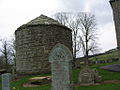
The ancient church at Bonkyl fell into ruin and was demolished in 1820 when the present church was built. All that is left of the old church is a Norman apse, a vaulted arch which was later used as a burial vault of the Homes of Billie. It is thought to be the oldest of its kind in Scotland, having been built in the early 12th century and is a designated scheduled monument. [4]

Ministers in the early years of the reformed church

See also

Related Research Articles

<span class="mw-page-title-main">Abbey St Bathans</span> Village in the Scottish Borders

Abbey St Bathans is a parish in the Lammermuir district of Berwickshire, in the eastern part of the Scottish Borders. Unique in its topography, it is situated in a long winding steep wooded valley that follows the Whiteadder Water. The parish had a population of 106 at the 2011 Census.

<span class="mw-page-title-main">Abbotrule</span> Hamlet in Scottish Borders, Scotland

Abbotrule is a hamlet south of the B6357 road, in the Scottish Borders area of Scotland, on Rule Burn, east of the Rule Water. Places nearby include Bedrule, Hallrule, Spittal-on-Rule, Ruletownhead, Bonchester Bridge, Denholm, Southdean, Hobkirk, Ferniehirst Castle and the Wauchope Forest.

<span class="mw-page-title-main">Dalmeny</span> Human settlement in Scotland

Dalmeny is a village and civil parish in Scotland. It is located on the south side of the Firth of Forth, 1 mile (1.6 km) southeast of South Queensferry and 8 miles (13 km) west of Edinburgh city centre. It lies within the traditional boundaries of West Lothian, and falls under the local governance of the City of Edinburgh Council.

<span class="mw-page-title-main">Keith Marischal</span> Historic site in Humbie, East Lothian

Keith Marischal is a Scottish Baronial Country house lying in the parish of Humbie, East Lothian, Scotland. The original building was an "L-shaped" Tower house, built long before 1589 when it was extended into a "U-shaped" courtyard house. The building acquired its modern appearance in the 19th century when the courtyard was filled in. The house is protected as a category B listed building.

<span class="mw-page-title-main">St Mary's Collegiate Church, Haddington</span>

The Collegiate Church of St Mary the Virgin is a Church of Scotland parish church in Haddington, East Lothian, Scotland.

<span class="mw-page-title-main">Cruggleton Castle</span> Castle in Scotland

Cruggleton Castle is a multi-period archaeological site on the coast of the Machars, in the historical county of Wigtownshire in south-west Scotland. It is located at Cruggleton Point, around 4.5 kilometres (2.8 mi) east of Whithorn and 6 kilometres (3.7 mi) south-east of Sorbie. Excavations in the 1970s and 1980s revealed several periods of use, from the 1st century AD to the 17th century. The first stone tower was built in the 13th century, on an earlier motte.

<span class="mw-page-title-main">Preston Mill</span> Human settlement in Scotland

Preston Mill is a watermill on the River Tyne at the eastern edge of East Linton on the B1407 Preston Road, in East Lothian, Scotland, UK. It is situated close to Prestonkirk Parish Church, the Smeaton Hepburn Estate, Smeaton Lake, and Phantassie Doocot. It is a Category A listed building.

<span class="mw-page-title-main">Bowden, Scottish Borders</span> Human settlement in Scotland

Bowden is a village in the Roxburghshire area of the Scottish Borders, situated 3 miles south of Melrose, 2 miles west of Newtown St Boswells and tucked in the shadow of the Eildon Hills, Scotland.

<span class="mw-page-title-main">Dirleton Kirk</span> Church in Scotland

Dirleton Kirk is a church in the village of Dirleton, in East Lothian, Scotland.

<span class="mw-page-title-main">Chirnside Parish Church</span>

Chirnside Parish Church is a kirk of the Church of Scotland. It is situated on the B6355 road between Duns and Eyemouth in the old county of Berwickshire, now part of the Scottish Borders, at grid reference NT869560. The town of Chirnside is 6 miles (9.7 km) east of Duns, and 9 miles (14 km) north-west of Berwick-upon-Tweed.

<span class="mw-page-title-main">Lyne, Scottish Borders</span>

Lyne is a small village and civil parish in the Scottish Borders area of Scotland, 4 miles (6.4 km) west of the market town of Peebles; it lies off the A72, in the old county of Peeblesshire and has an area of about 4 square miles (10 km2).

<span class="mw-page-title-main">Preston, Scottish Borders</span> Human settlement in Scotland

Preston is a small village in the ancient county of Berwickshire, now an administrative area of the Scottish Borders region of Scotland. It lies within the local Abbey St Bathans, Bonkyl & Preston Community Council area.

<span class="mw-page-title-main">Edrom</span> Human settlement in Scotland

Edrom is a parish and small village in the pre-1975 ancient county of Berwickshire, now an administrative area of the Scottish Borders region of Scotland.

<span class="mw-page-title-main">Eckford, Scottish Borders</span>

Eckford is a small village located between the larger towns of Kelso and Jedburgh in the Scottish Borders. The village is in close proximity to both the River Teviot and its tributary the Kale Water, and the A698 and the B6401 which run approximately parallel to the respective rivers.

<span class="mw-page-title-main">Falkirk Old Parish Church</span> Church in Falkirk, Scotland

Falkirk Old & St. Modan's Parish Church, also known as "Falkirk Trinity Church", is a congregation of the Church of Scotland in Falkirk, central Scotland. The medieval Old Parish Church is located in the centre of Falkirk, and may have been founded as early as the 7th century. The church was largely rebuilt in the 19th century, though the 18th-century steeple was retained. The church building is protected as a category A listed building.

<span class="mw-page-title-main">John Stewart, 1st Earl of Angus</span>

John Stewart, 1st Earl of Angus, Lord of Bonkyl, jure uxorisLord of Abernethy was a medieval Scottish nobleman.

<span class="mw-page-title-main">Bonkyll Castle</span> Castle in Scottish Borders, Scotland, UK

Bonkyll Castle was a medieval fortress situated in the historic Scottish county of Berwickshire, from 1973 the Scottish Borders. It is situated 4 miles north of Duns and 4 miles south of Grantshouse. Few traces survive and the site is protected as a scheduled monument. It was the seat of a junior branch of the Stewart family, known as "Stewart of Bonkyl", from which was descended in another junior branch "Stewart of Darnley", the paternal family of King James I & VI of Scotland and England.

<span class="mw-page-title-main">James Hay, 7th Lord Hay of Yester</span> Scottish landowner and courtier (1564–1609)

James Hay, 7th Lord Hay of Yester (1564-1609) was a Scottish landowner and courtier.

References

  1. "Bunkle". www.ainmean-aite.scot. Retrieved 20 September 2022.
  2. "People of Medieval Scotland". Archived from the original on 18 April 2021.
  3. Historic Environment Scotland. "Bonkyl Parish Church including graveyard, boundary walls, quadrant walls, gatepiers and gates and excluding scheduled monument SM381, Preston (Category B Listed Building) (LB216)" . Retrieved 21 February 2019.
  4. Historic Environment Scotland. "Bonkyl and Preston parish church, church 10m S of (SM381)" . Retrieved 21 February 2019.

55°49′44″N2°18′26″W / 55.82889°N 2.30722°W / 55.82889; -2.30722