Ellesmere Island is Canada's northernmost and third largest island, and the tenth largest in the world. It comprises an area of 196,236 km2 (75,767 sq mi), slightly smaller than Great Britain, and the total length of the island is 830 km (520 mi).

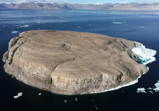
Hans Island is an island in the centre of the Kennedy Channel of Nares Strait in the high Arctic region, split between the Canadian territory of Nunavut and the Danish autonomous territory of Greenland. The island itself is barren and uninhabited with an area of 130 hectares, measuring 1,290 by 1,199 metres, and a maximum elevation of 168.17 m (551.7 ft). Its location in the strait that separates Ellesmere Island of Canada from northern Greenland was for years a border dispute, the so-called Whisky War between the two countries of Canada and Denmark. Hans Island is the smallest of three islands in Kennedy Channel off the Washington Land coast; the others are Franklin Island and Crozier Island. The strait at this point is 35 km (22 mi) wide, placing the island within the territorial waters of both Canada and Denmark (Greenland). A 1,280-metre-long (4,200 ft) shared border traverses the island.

Elisha Kent Kane was a United States Navy medical officer and Arctic explorer. He served as assistant surgeon during Caleb Cushing's journey to China to negotiate the Treaty of Wangxia and in the Africa Squadron. He was assigned as a special envoy to the United States Army during the Mexican–American War and as a surveyor in the United States Coast Survey.

The first USS Advance was a brigantine in the United States Navy which participated in an Arctic rescue expedition. Advance was built in 1847 as Augusta in New Kent County, Virginia and loaned to the Navy on 7 May 1850 by Henry Grinnell to participate in the search for Sir John Franklin's Arctic expedition which had been stranded in the frozen north since 1846. After last-minute preparations, the ship, under the command of Lieutenant Edwin J. De Haven and in company with Rescue, put to sea from New York on 23 May 1850.

Iqaluit Airport serves Iqaluit, Nunavut, Canada and is located adjacent to the city. It hosts scheduled passenger service from Ottawa, Montreal, Rankin Inlet, and Kuujjuaq on carriers such as Canadian North, and from smaller communities throughout eastern Nunavut. It is also used as a forward operating base by the Royal Canadian Air Force (RCAF). In 2011, the terminal handled more than 120,000 passengers.

Franklin Island is one of three islands located in Kennedy Channel of Nares Strait in the high Arctic and is part of Avannaata municipality, Greenland.

Crozier Island is one of three islands located in the Kennedy Channel section of Nares Strait in the high Arctic. It is part of the Avannaata municipality, Greenland.

Kane Basin is an Arctic waterway lying between Greenland and Canada's northernmost island, Ellesmere Island. It links Smith Sound to Kennedy Channel and forms part of Nares Strait. It is approximately 180 kilometres in length and 130 km at its widest.

Qeqertarsuatsiaat, formerly Fiskenæsset or Fiskernæs, is a settlement in the Sermersooq municipality in southwestern Greenland, located on an island off the shores of Labrador Sea. Its population was 169 in 2020.

The first USS Rescue was a brig in service with the United States Navy.

Clavering Island is a large island in eastern Greenland off Gael Hamke Bay, to the south of Wollaston Foreland.
Sabine Island is an island to the northeast of Wollaston Foreland, previously known as Inner Pendulum Island. It is in the Northeast Greenland National Park area.

The Littleton Islands, are a group of two small coastal islands, the largest of which is Littleton Island. They are located in the Avannaata municipality, off NW Greenland.

The second Grinnell expedition of 1853–1855 was an American effort, financed by Henry Grinnell, to determine the fate of the Franklin's lost expedition. Led by Elisha Kent Kane, the team explored areas northwest of Greenland, now called Grinnell Land.

Cape Morton is a headland in North Greenland in Avannaata municipality. The cape is named after Arctic explorer William Morton, who surveyed the Nares Strait area together with Hans Hendrik in June 1854 during the Second Grinnell Expedition.

Antarctic was a Swedish steamship built in Drammen, Norway, in 1871. She was used on several research expeditions to the Arctic region and to Antarctica from 1893 to 1903. In 1895 the first confirmed landing on the mainland of Antarctica was made from this ship.
The McGary Islands is a small coastal island group in Avannaata municipality, off NW Greenland.
Peabody Bay is a large bay in northwestern Greenland. Administratively it is part of Avannaata municipality.
Port Refuge is located off the south coast of Grinnell Peninsula in a small bay on the south coast of Devon Island in Nunavut, Canada. The site received its current name by Sir Edward Belcher when he sought refuge there in 1852-1853 from moving ice during his voyage in search of the missing Franklin Expedition.


