The Territory of Heard Island and McDonald Islands (HIMI) is an Australian external territory comprising a volcanic group of mostly barren Antarctic islands, about two-thirds of the way from Madagascar to Antarctica. The group's overall size is 372 km2 (144 sq mi) in area and it has 101.9 km (63 mi) of coastline. Discovered in the mid-19th century, the islands lie on the Kerguelen Plateau in the Indian Ocean and have been an Australian territory since 1947. They contain Australia's only two active volcanoes. The summit of one, Mawson Peak, is higher than any mountain in all other Australian states or territories, except Dome Argus, Mount McClintock and Mount Menzies in the Australian Antarctic Territory.

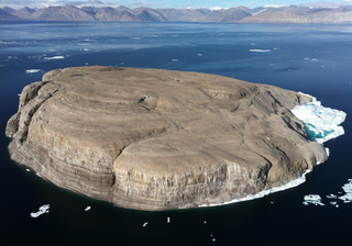
Hans Island is an island in the very centre of the Kennedy Channel of Nares Strait in the high Arctic region, split between the Canadian territory of Nunavut and the Danish autonomous country of Greenland. The island itself is barren and uninhabited with an area of 1.3 square kilometres (0.50 sq mi), measuring 1,290 by 1,199 metres, and a maximum elevation of 168.17 m (551.7 ft). Its location in the strait that separates Ellesmere Island of Canada from northern Greenland was for years a border dispute, the so-called Whisky War between the two countries of Canada and Denmark. Hans Island is the smallest of three islands in Kennedy Channel off the Washington Land coast; the others are Franklin Island and Crozier Island. The strait at this point is 35 km (22 mi) wide, placing the island within the territorial waters of both Canada and Denmark (Greenland). A 1,280-metre-long (4,200 ft) border traverses the island.

The Greenland Sea is a body of water that borders Greenland to the west, the Svalbard archipelago to the east, Fram Strait and the Arctic Ocean to the north, and the Norwegian Sea and Iceland to the south. The Greenland Sea is often defined as part of the Arctic Ocean, sometimes as part of the Atlantic Ocean. However, definitions of the Arctic Ocean and its seas tend to be imprecise or arbitrary. In general usage the term "Arctic Ocean" would exclude the Greenland Sea. In oceanographic studies the Greenland Sea is considered part of the Nordic Seas, along with the Norwegian Sea. The Nordic Seas are the main connection between the Arctic and Atlantic oceans and, as such, could be of great significance in a possible shutdown of thermohaline circulation. In oceanography the Arctic Ocean and Nordic Seas are often referred to collectively as the "Arctic Mediterranean Sea", a marginal sea of the Atlantic.

The first USS Advance was a brigantine in the United States Navy which participated in an Arctic rescue expedition. Advance was built in 1847 as Augusta in New Kent County, Virginia and loaned to the Navy on 7 May 1850 by Henry Grinnell to participate in the search for Sir John Franklin's Arctic expedition which had been stranded in the frozen north since 1846. After last-minute preparations, the ship, under the command of Lieutenant Edwin J. De Haven and in company with Rescue, put to sea from New York on 23 May 1850.
Cape York is a cape on the northwestern coast of Greenland, in northern Baffin Bay.

Kane Basin is an Arctic waterway lying between Greenland and Canada's northernmost island, Ellesmere Island. It links Smith Sound to Kennedy Channel and forms part of Nares Strait. It is approximately 180 kilometres in length and 130 km at its widest.
Hendrik Island is an island in far northern Greenland. Its area is 583 km2. It is part of the Northeast Greenland National Park.

Clavering Island is a large island in eastern Greenland off Gael Hamke Bay, to the south of Wollaston Foreland.

Kaiser Franz Joseph Fjord is a major fjord system in the NE Greenland National Park area, East Greenland.

The Littleton Islands, are a group of two small coastal islands, the largest of which is Littleton Island. They are located in the Avannaata municipality, off NW Greenland.

The second Grinnell expedition of 1853–1855 was an American effort, financed by Henry Grinnell, to determine the fate of the Franklin's lost expedition. Led by Elisha Kent Kane, the team explored areas northwest of Greenland, now called Grinnell Land.
Norske Islands, Danish: Norske Øer; meaning 'Norse Islands', is a group of two uninhabited islands of the Greenland Sea, Greenland.

Cape Morton is a headland in North Greenland in Avannaata municipality. The cape is named after Arctic explorer William Morton, who surveyed the Nares Strait area together with Hans Hendrik in June 1854 during the Second Grinnell Expedition.
Steward Island is an uninhabited island in King Christian IX Land, at the eastern end of Greenland. Administratively it is part of the Sermersooq municipality.
The Bonsall Islands is a small coastal island cluster in the Avannaata municipality, off northwest Greenland.
Peabody Bay is a large bay in northwestern Greenland. Administratively it is part of Avannaata municipality.
Iluileq is an uninhabited island in the Kujalleq municipality in southern Greenland.

King Frederick VI Coast is a major geographic division of Greenland. It comprises the coastal area of Southeastern Greenland in Sermersooq and Kujalleq municipalities fronting the Irminger Sea of the North Atlantic Ocean. It is bordered by King Christian IX Land on the north and the Greenland Ice Sheet to the west.

The Denmark expedition, also known as the Denmark Expedition to Greenland's Northeast Coast, and as the Danmark Expedition after the ship, was an expedition to the northeast of Greenland in 1906–1908. Despite being overshadowed by the death in tragic circumstances of the main exploration team, including three of the expedition's leading members: Ludvig Mylius-Erichsen (1872–1907), Niels Peter Høeg Hagen (1877–1907) and Jørgen Brønlund (1877–1907), the Denmark expedition was not a failure. It achieved its main cartographic objectives and succeeded in exploring the vast region, drawing accurate charts of formerly unexplored coastlines and fjords, naming numerous geographic features, and gathering a wealth of scientific data.


