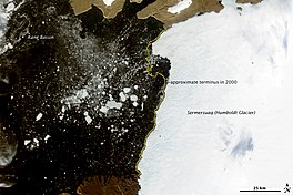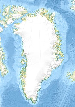
Kane Basin is an Arctic waterway lying between Greenland and Ellesmere Island, Canada's northernmost. It links Smith Sound to Kennedy Channel and forms part of Nares Strait. It is approximately 180 km (110 mi) in length and 130 km (81 mi) at its widest.
The Holocene glacial retreat is a geographical phenomenon that involved the global retreat of glaciers (deglaciation) that previously had advanced during the Last Glacial Maximum. Ice sheet retreat initiated ca. 19,000 years ago and accelerated after ca. 15,000 years ago. The Holocene, starting with abrupt warming 11,700 years ago, resulted in rapid melting of the remaining ice sheets of North America and Europe.

The retreat of glaciers since 1850 is a well-documented effect of climate change. The retreat of mountain glaciers provide evidence for the rise in global temperatures since the late 19th century. Examples include mountain glaciers in western North America, Asia, the Alps in central Europe, and tropical and subtropical regions of South America and Africa. Since glacial mass is affected by long-term climatic changes, e.g. precipitation, mean temperature, and cloud cover, glacial mass changes are one of the most sensitive indicators of climate change. The retreat of glaciers is also a major reason for sea level rise. Excluding peripheral glaciers of ice sheets, the total cumulated global glacial losses over the 26 years from 1993 to 2018 were likely 5500 gigatons, or 210 gigatons per year.

Petermann Glacier is a large glacier located in North-West Greenland to the east of Nares Strait. It connects the Greenland ice sheet to the Arctic Ocean at 81°10' north latitude, near Hans Island.

Zachariae Isstrom is a large glacier located in King Frederick VIII Land, northeast Greenland.

Nioghalvfjerdsbrae, sometimes referred to as "79 N Glacier", is a large glacier located in King Frederick VIII Land, northeastern Greenland. It drains an area of 103,314 km2 (39,890 sq mi) of the Greenland Ice Sheet with a flux of 14.3 km3 (3.4 cu mi) per year, as measured for 1996. The glacier has two calving fronts where the glacier meets the ocean, separated by Hovgaard Island. In July 2020, the northern offshoot, the Spalte Glacier broke away from Nioghalvfjerdsbrae and completely disintegrated.
Nunatarsuaq is a nunatak in Avannaata municipality in northwestern Greenland.
Anoritooq is a nunatak in Avannaata municipality in northwestern Greenland.
The McGary Islands is a small coastal island group in Avannaata municipality, off NW Greenland.
Peabody Bay is a large bay in northwestern Greenland. Administratively it is part of Avannaata municipality.

Bernstorff Fjord is a fjord in King Frederick VI Coast, eastern Greenland.
Puisortoq is a glacier on the east coast of Greenland. It has been in a status of retreat for the past years.
Washington Land is a peninsula in northwestern Greenland. It is a part of the Avannaata municipality.

Ryder Glacier, is one of the major glaciers in northern Greenland.

Steensby Glacier is a major glacier in northern Greenland.

Inglefield Gulf or Inglefield Fjord is a fjord in northwestern Greenland. To the west, the fjord opens into the Baffin Bay. Administratively it belongs to the Avannaata municipality.
Rink Glacier, is a glacier in NW Greenland. Administratively it belongs to the Avannaata municipality.

Godthab Gulf, also known as Godthaab Golf, Clavering Fjord, Clavering Sound and Inner Bay, is a fjord in King Christian X Land, East Greenland. Administratively it is part of the Northeast Greenland National Park zone.

Dodge Glacier, is a glacier in northwestern Greenland. Administratively it belongs to the Avannaata municipality.


