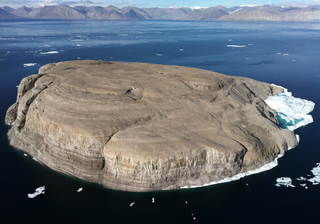
Hans Island is an island in the centre of the Kennedy Channel of Nares Strait in the high Arctic region, split between the Canadian territory of Nunavut and the Danish autonomous territory of Greenland. The island itself is barren and uninhabited with an area of 130 hectares, measuring 1,290 by 1,199 metres, and a maximum elevation of 168.17 m (551.7 ft). Its location in the strait that separates Ellesmere Island of Canada from northern Greenland was for years a border dispute, the so-called Whisky War between the two countries of Canada and Denmark. Hans Island is the smallest of three islands in Kennedy Channel off the Washington Land coast; the others are Franklin Island and Crozier Island. The strait at this point is 35 km (22 mi) wide, placing the island within the territorial waters of both Canada and Denmark (Greenland). A 1,280-metre-long (4,200 ft) shared border traverses the island.

HMS Resolute was a mid-19th-century barque-rigged ship of the British Royal Navy, specially outfitted for Arctic exploration. Resolute became trapped in the ice searching for Franklin's lost expedition and was abandoned in 1854. Recovered by an American whaler, she was returned to Queen Victoria in 1856. Timbers from the ship were later used to construct the Resolute desk which was presented to the President of the United States and is located in the White House Oval Office.

Isaac Israel Hayes was an American Arctic explorer, physician, and politician, who was appointed as the commanding officer at Satterlee General Hospital during the American Civil War, and was then elected, after the war, to the New York State Assembly.

Elisha Kent Kane was a United States Navy medical officer and Arctic explorer. He served as assistant surgeon during Caleb Cushing's journey to China to negotiate the Treaty of Wangxia and in the Africa Squadron. He was assigned as a special envoy to the United States Army during the Mexican–American War and as a surveyor in the United States Coast Survey.

The first USS Advance was a brigantine in the United States Navy which participated in an Arctic rescue expedition. Advance was built in 1847 as Augusta in New Kent County, Virginia and loaned to the Navy on 7 May 1850 by Henry Grinnell to participate in the search for Sir John Franklin's Arctic expedition which had been stranded in the frozen north since 1846. After last-minute preparations, the ship, under the command of Lieutenant Edwin J. De Haven and in company with Rescue, put to sea from New York on 23 May 1850.

Johan Carl Christian Petersen was a Danish seaman and interpreter who participated in several expeditions in Northern Canada and Greenland in search of the missing British explorer John Franklin.

Hans Hendrik was a Kalaallit interpreter, Arctic explorer, and the first Inuk to publish an account of his travels. He was born in the southern settlement of Fiskenæsset.

Kennedy Channel is an Arctic sea passage between Greenland and Canada's most northerly island, Ellesmere Island.

Franklin Island is one of three islands located in Kennedy Channel of Nares Strait in the high Arctic and is part of Avannaata municipality, Greenland.

Crozier Island is one of three islands located in the Kennedy Channel section of Nares Strait in the high Arctic. It is part of the Avannaata municipality, Greenland.

Kane Basin is an Arctic waterway lying between Greenland and Ellesmere Island, Canada's northernmost. It links Smith Sound to Kennedy Channel and forms part of Nares Strait. It is approximately 180 km (110 mi) in length and 130 km (81 mi) at its widest.

The Littleton Islands, are a group of two small coastal islands, the largest of which is Littleton Island. They are located in the Avannaata municipality, off NW Greenland.
Lady Franklin Bay is an Arctic waterway in the Qikiqtaaluk Region, Nunavut, Canada. The bay is located in Nares Strait, northwest of Judge Daly Promontory and is an inlet into the northeastern shore of Ellesmere Island.

Grinnell Land is the central section of Ellesmere Island in the northernmost part of Nunavut territory in Canada. It was named for Henry Grinnell, a shipping magnate from New York, who in the 1850s helped finance two expeditions to search for Franklin's lost expedition.

Humboldt Glacier is one of the major glaciers in northern Greenland.

The second Grinnell expedition of 1853–1855 was an American effort, financed by Henry Grinnell, to determine the fate of the Franklin's lost expedition. Led by Elisha Kent Kane, the team explored areas northwest of Greenland, now called Grinnell Land.
The First Grinnell expedition of 1850 was the first American effort, financed by Henry Grinnell, to determine the fate of the lost Franklin Northwest Passage expedition. Led by Lieutenant Edwin De Haven, the team explored the accessible areas along Franklin's proposed route. In coordination with British expeditions, they identified the remains of Franklin's Beechey Island winter camp, providing the first solid clues to Franklin's activities during the winter of 1845, before becoming icebound themselves.
The Bonsall Islands is a small coastal island cluster in the Avannaata municipality, off northwest Greenland.
The McGary Islands is a small coastal island group in Avannaata municipality, off NW Greenland.


