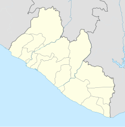
Liberia, officially the Republic of Liberia, is a country on the West African coast. It is bordered by Sierra Leone to its northwest, Guinea to its north, Ivory Coast to its east, and the Atlantic Ocean to its south and southwest. It has a population of around 5 million and covers an area of 43,000 square miles (111,369 km2). English is the official language, but over 20 indigenous languages are spoken, reflecting the country's ethnic and cultural diversity. The country's capital and largest city is Monrovia.
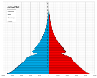
As of 2006, Liberia has the highest population growth rate in the world. 43.5% of Liberians were below the age of 15 in 2010. With recent civil wars being fought along ethnic lines, Liberia is a multiethnic and multicultural country.

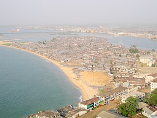
Monrovia is the capital city of the West African country of Liberia. Founded in 1822, it is located on Cape Mesurado on the Atlantic coast and as of the 2008 census had 1,010,970 residents, home to 29% of Liberia’s total population. As the nation's primate city, Monrovia is the country's economic, financial and cultural center; its economy is primarily centered on its harbor and its role as the seat of Liberian government.
The culture of Liberia reflects this nation's diverse ethnicities and long history. Liberia is located in West Africa on the Atlantic Coast.

Montserrado County is a county in the northwestern portion of the West African nation of Liberia containing its national capital, Monrovia. One of 15 counties that comprise the first-level of administrative division in the nation, it has 17 sub political districts. As of the 2008 Census, it had a population of 1,118,241, making it the most populous county in Liberia. The area of the county measures 1,912.7 square kilometres (738.5 sq mi), the smallest in the country. Bensonville serves as the capital.

Grand Cape Mount is a county in the northwestern portion of the West African nation of Liberia. One of 15 counties that constitute the first-level of administrative division in the nation, it has five districts. Robertsport serves as the capital with the area of the county measuring 5,162 square kilometres (1,993 sq mi). As of the 2008 Census, it had a population of 129,817, making it the eighth most populous county in Liberia. The county is bordered by Gbarpolu County to the northeast and Bomi County to the southeast. The northern part of Grand Cape Mount borders the nation of Sierra Leone, while to the west lies the Atlantic Ocean.
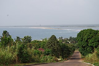
Robertsport is a town in western Liberia, about 10 miles from the Sierra Leone border. It is named after Joseph Jenkins Roberts, the first president of Liberia.

Tubmanburg, also known as Bomi and formerly known as Vaitown, is the capital of Bomi County in Liberia. It lies in the Bomi Hills northwest of Monrovia and was an iron ore and diamond mining centre until it was largely destroyed in the First Liberian Civil War. During the Second Liberian Civil War, it was the headquarters of the Liberians United for Reconciliation and Democracy rebel group. Most residents are members of the Vai tribe.

Gbarpolu is a county in the northern portion of Liberia. One of 15 counties that comprise the first-level of administrative division in the nation, it has six districts. Bopulu serves as the capital with the area of the county measuring 9,689 square kilometres (3,741 sq mi). As of the 2008 Census, it had a population of 83,758, making it the eleventh-most populous county in Liberia.

The Vai are a Mande-speaking ethnic group that live mostly in Liberia, with a small minority living in south-eastern Sierra Leone. The Vai are known for their indigenous syllabic writing system known as Vai syllabary, developed in the 1820s by Momolu Duwalu Bukele and other Vai elders. Over the course of the 19th century, literacy in the writing system became widespread. Its use declined over the 20th century, but modern computer technology may enable a revival.
Bomi is a county in the northwestern portion of the West African nation of Liberia. The county was established in 1984. The county's area is 746 square miles (1,900 km2).

Margibi is a county on the north to central coast of Liberia. One of 15 counties that constitute the first-level of administrative division in the nation, it has five districts. Kakata serves as the capital with the area of the county measuring 2,616 square kilometres (1,010 sq mi). As of the 2008 Census, it had a population of 199,689, making it the sixth most populous county in Liberia.
The Gola or Gula are a West African ethnic group who share a common cultural heritage, language and history and who live primarily in western/northwestern Liberia and Eastern Sierra Leone. The Gola language is an isolate within the Niger–Congo language family. As of 2015, it is spoken by about 278,000 people.
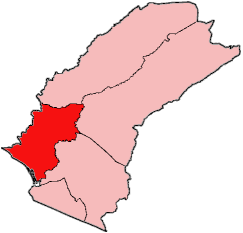
Tewor District is one of five districts located in Grand Cape Mount County, Liberia. As of the 2008 Census, it has a population of 27,460.
St. Paul River is a district located in Montserrado County, Liberia. It recorded a population of 71,831 in the 2008 census. It has no official administrative status. Its inhabitants are primarily Christians and members of the Bassa, Dey, or Kpelle tribes. Farming and fishing are the main economic activities along with some small scale trading. The district has one paved road.

The Vai syllabary is a syllabic writing system devised for the Vai language by Momolu Duwalu Bukele of Jondu, in what is now Grand Cape Mount County, Liberia. Bukele is regarded within the Vai community, as well as by most scholars, as the syllabary's inventor and chief promoter when it was first documented in the 1830s. It is one of the two most successful indigenous scripts in West Africa in terms of the number of current users and the availability of literature written in the script, the other being N'Ko.
Liberian Americans are an ethnic group of Americans of full or partial Liberian ancestry. This can include Liberians who are descendants of Americo-Liberian people in America. The first wave of Liberians to the United States, after the slavery period, was after of the First Liberian Civil War in the 1990s and, then, after the Second Liberian Civil War in the early 2000s.
Christianity is the predominant religion in Liberia, with Protestantism being its largest denomination. Muslims are the largest minority group, largely coming from the Mandingo and Vai ethnic groups. The vast majority of Muslims are Malikite Sunni, with sizeable Shia and Ahmadiyya minorities.
Bushrod Island is an island near Monrovia, Liberia surrounded by the Atlantic Ocean, the Saint Paul River, the Mesurado River and Stockton Creek. It contains the Freeport of Monrovia, the major national port of Liberia and a variety of businesses. It also contains numerous residential areas and government buildings. There are four towns on the island, Vai Town, New Kru Town, Logan Town and Clara Town.

Bopolu is an impact crater located within the Meridiani Planum extraterrestrial plain of Mars. Bopulu was seen by Opportunity rover in 2010 in the distance, and with some of its rim visible. Bopoplu was officially named in 2006 along with 31 Mars craters. Research has indicated that the impact that is thought to have created Bopulu went so deep that it went through existing layers and ejected older material from Mars' Noachian period. Bopulu is a 19 kilometres (12 mi) diameter wide crater south of the Opportunity MER-B landing site, a rover which operated in the region starting in 2004 and therefore resulted in greater exploration and study of craters in this region. Bopulu was identified as a possible source for the Bounce Rock ejecta fragment Bounce rock, which was examined by the MER-B rover, was found to be similar in composition to the shergottite class of Mars meteorite found on Earth.