French Polynesia is an overseas collectivity of France and its sole overseas country. It comprises 121 geographically dispersed islands and atolls stretching over more than 2,000 kilometres (1,200 mi) in the South Pacific Ocean. The total land area of French Polynesia is 3,521 square kilometres (1,359 sq mi), with a population of 278,786 of which at least 205,000 live in the Society Islands and the remaining population lives in the rest of the archipelago.
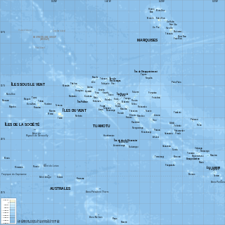
French Polynesia is located in Oceania. It is a group of six archipelagos in the South Pacific Ocean, about halfway between South America and Australia. Its area is about 4,167 km2, of which 3,827 km2 is land and 340 km2 is (inland) water. It has a coastline of 2,525 km but no land borders with other countries.

Tubuai, Tubuaʻi or Tupuaʻi is the main island of the Austral Island group, located 640 km (400 mi) south of Tahiti. In addition to Tubuai, the group of islands include Rimatara, Rurutu, Raivavae, Rapa and the uninhabited Îles Maria. They are part of the Austral Islands in the far southwest of French Polynesia in the south Pacific Ocean. Tubuai island sustains a population of 2,185 people on 45 km2 of land. Due to its southerly position, Tubuai has notably cooler weather than Tahiti.

Bora Bora is an island group in the Leeward Islands in the South Pacific. The Leeward Islands comprise the western part of the Society Islands of French Polynesia, which is an overseas collectivity of the French Republic in the Pacific Ocean. Bora Bora has a total land area of 30.55 km2 (12 sq mi). The main island, located about 230 kilometres northwest of Papeete, is surrounded by a lagoon and a barrier reef. In the center of the island are the remnants of an extinct volcano, rising to two peaks, Mount Pahia and Mount Otemanu; the highest point is at 727 m (2,385 ft). Bora Bora is part of the Commune of Bora-Bora, which also includes the atoll of Tūpai. The main languages spoken in Bora Bora are Tahitian and French. However, due to the high tourist population, many natives of Bora Bora have learned to speak English.

Taha’a is an island located among the western group, the Leeward Islands, of the Society Islands in French Polynesia, an overseas territory of France in the South Pacific Ocean. The islands of Taha’a and neighboring Raiatea to the immediate south are enclosed by the same coral reef, and they may once have been a single island. At the 2022 census it had a population of 5,296. The island has an area of 90 square kilometres. Mount Ohiri is the highest mountain on the island standing at 590 metres (1,940 ft) above sea level. It is also known as the "Vanilla Island" and produces pearls of exceptional quality.
The Gambier Islands are an archipelago in French Polynesia, located at the southeast terminus of the Tuamotu archipelago. They cover an area of 27.8 km2 or 10.7 sq mi, and are made up of the Mangareva Islands, a group of high islands remnants of a caldera along with islets on the surrounding fringing reef, and the uninhabited Temoe atoll, which is located 45 km south-east of the Mangareva Islands. The Gambiers are generally considered a separate island group from Tuamotu both because their culture and language (Mangarevan) are much more closely related to those of the Marquesas Islands, and because, while the Tuamotus comprise several chains of coral atolls, the Mangareva Islands are of volcanic origin with central high islands.
The Leeward Islands are the western part of the Society Islands in French Polynesia, an overseas collectivity of France, in the South Pacific Ocean. They lie south of the Line Islands, east of the Cooks and north of the Austral Islands. Their area is 404 km2 and their population is over 36,000.

Puna'auia is a commune in the suburbs of Papeʻete in French Polynesia, an overseas territory of France in the Pacific Ocean. Puna'auia is located on the island of Tahiti, in the administrative subdivision of the Windward Islands, themselves part of the Society Islands. In the late 1890s, the French painter Paul Gauguin lived in Puna'auia. Here he painted his masterpiece Where Do We Come From? What Are We? Where Are We Going?. The commune borders Faʻaʻā on the north and Pāʻea on the south.

Uturoa is a commune located in Ra'iātea, the largest island of the Îles Sous le Vent in French Polynesia, in the South Pacific Ocean. It is situated in between the administrative subdivision of Leeward Islands and the main port of the island of Ra'iātea. According to the 2022 census, Uturoa has a population of 3,663. The commune lies approximately 120 miles (193.121 km) northwest of Pape'ete, the capital of French Polynesia.

Pāʻea is a commune in the suburbs of Papeʻete in French Polynesia, an overseas territory of France in the southern Pacific Ocean. Pāʻea is located on the island of Tahiti, in the administrative subdivision of the Windward Islands, themselves part of the Society Islands. At the 2022 census it had a population of 12,756.

Paparā is a commune of French Polynesia, an overseas territory of France in the Pacific Ocean. Paparā is located on the island of Tahiti, in the administrative subdivision of the Windward Islands, themselves part of the Society Islands. At the 2022 census it had a population of 11,743.

Anaa, Nganaa-nui is an atoll in the Tuamotu archipelago, in French Polynesia. It is located in the north-west of the archipelago, 350 km to the east of Tahiti. It is oval in shape, 29.5 km in length and 6.5 km wide, with a total land area of 38 km2 and a population of 504. The atoll is made up by eleven small barren islands with deeper and more fertile soil than other atolls in the Tuamotus. The lagoon is shallow, without entrance, and formed by three main basins. Although it does not have any navigable access, the water of the lagoon renews by several small channels that can be crossed walking.

Makemo, Rangi-kemo or Te Paritua, is an inhabited atoll in the Tuamotu archipelago in French Polynesia.
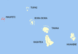
Maupiti is a commune of French Polynesia, an overseas territory of France in the Pacific Ocean. The commune is in the administrative subdivision of the Leeward Islands.

Arutua, or Ngaru-atua is an atoll in the Tuamotu group in French Polynesia. It is located 40 km SW of Rangiroa. The closest land is Apataki Atoll, only 16 km to the East.
Takaroa, Taka-roa or Takapua, is an atoll in the Tuamotu group in French Polynesia. It has a length of 27.4 kilometres and a width of 7 km (4 mi); its land area is 20 square kilometres.

Tatakoto is an atoll in the Tuamotu group in French Polynesia.

Nuku-Hiva is a commune of French Polynesia, an overseas territory of France in the Pacific Ocean. The commune is in the administrative subdivision of the Marquesas Islands. Its population was 3,025 at the 2022 census.

Gambier is a commune of French Polynesia in the administrative subdivision of the Tuamotu-Gambier Islands. The commune includes the Gambier Islands as well as several atolls in the Tuamotu Archipelago. All the Tuamotu atolls belonging to the commune are uninhabited except for Marutea Sud, and are sometimes mistakenly included among the Gambier Islands themselves. The commune population was 1,570 at the 2022 census. Its total land area is 45.97 km2.
Fa'a'aha is an associated commune located in the island commune of Taha'a, in French Polynesia. It is situated in the subdivision of the Leeward Islands, an overseas collectivity of French Polynesia.


