
Australia's Highway 1 is a network of highways that circumnavigate the country, joining all mainland capital cities except the national capital of Canberra. At a total length of approximately 14,500 km (9,000 mi) it is the longest national highway in the world, surpassing the Trans-Siberian Highway and the Trans-Canada Highway. Over a million people traverse some part of the highway network every day. It is the longest continuing highway in the world as the Pan-American Highway is separated by the Darién Gap and AH1 is separated by the Sea of Japan. However it is not the longest continuous stretch of highway as both the northern section of the Pan-American Highway and the continental section of AH1 still out-measure it.
Australian vehicle registration plates, number plates and license plates are issued by state, territory, and Commonwealth governments, and the armed forces of Australia. The plates are associated with a vehicle and are generally intended to last during the time that the vehicle remains registered in the state, though as they become unreadable they may be remade with a like for like replacement. Motor vehicle registration in Australia can be renewed monthly, quarterly, half yearly or annually depending on the state or territory where the vehicle is registered.

The Sheffield Shield is the domestic first-class cricket competition of Australia. The tournament is contested between teams representing the six states of Australia. The Sheffield Shield is named after Lord Sheffield.
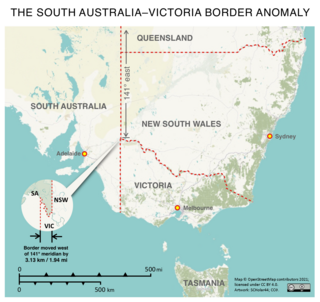
The border between the Australian states of South Australia and Victoria was established in 1836 by imperial letters patent "as the 141st degree meridian of longitude east of Greenwich". In 1836 the land in what is now called Victoria was part of the colony of New South Wales, the original Victorian border was drawn between the colonies of South Australia and New South Wales. An error came about in establishing the position of the 141st meridian, and more than 75 years and a protracted legal dispute passed before the precise placement of the border was settled, resulting in the forfeiture of more than 1,300 km2 (500 sq mi) of territory from South Australia to Victoria.

Australia uses three main time zones: Australian Eastern Standard Time, Australian Central Standard Time and Australian Western Standard Time.

Haddon Corner is a heritage-listed site in Tanbar, Shire of Barcoo, Queensland, Australia. It is in outback Channel Country at South-West Queensland, on the border corner with South Australia. It was added to the Queensland Heritage Register on 9 November 2012.

Surveyor Generals Corner is the point where the Australian state boundaries of South Australia, Western Australia and the Northern Territory meet.

The land border of the state of Western Australia (WA) bisects mainland Australia, nominally along 129th meridian east longitude. That land border divides WA from the Northern Territory (NT) and South Australia (SA). However, for various reasons, the actual border deviates from 129° east, and is not a single straight line.

Postcodes in Australia are used to more efficiently sort and route mail within the Australian postal system. Postcodes in Australia have four digits and are placed at the end of the Australian address, before the country. Postcodes were introduced in Australia in 1967 by the Postmaster-General's Department and are now managed by Australia Post, Australia's national postal service. Postcodes are published in booklets available from post offices or online from the Australia Post website.
Several Queensland and New South Wales boundary encroachments are anomalies along the boundary between the Australian states of New South Wales and Queensland. Due to various historical anomalies, several stations and properties that are officially part of Queensland are south of the 29 degrees south parallel, marking the official border. Three of these can be seen easily on Google Maps near Cameron Corner, where the New South Wales Lands Department surveyor John Brewer Cameron, who spent two years from 1880 marking the border between NSW and Queensland, erected a post in September 1880.

The Australian Tertiary Admission Rank (ATAR) for all domestic students, or the ATAR-based Combined Rank (CR) for all International Baccalaureate (IB) students, are the primary criteria for determining the Selection Rank (SR) for admission into undergraduate courses in Australian public universities. Domestic Students are students who are Australian or New Zealand citizens, or Australian permanent residents, or the holder of long-term refugee visa. ATAR & CR are not applicable for international students as they must apply directly to each university separately and their SR is calculated by the university. The ATAR is calculated by each state or territory's own state-level Tertiary Admission Center (TAC) for all domestic students studying within their geographical limits. Interstate Domestic Students must apply to the TAC of their respective state. The Selection Rank is calculated by each University separately based on the ATAR or CR as well as additional points for each university's unique criteria such as a student's educational disadvantage or subject performance. ATAR is not a mark, but rather a percentile ranking between 0.00 and 99.95 which shows the student’s relative position compared to all other students in the range of 16 to 20 years old who would have completed their respective year 12 exams in that state in a year.
Today South Australia's land borders are defined to the west by the 129° east longitude with Western Australia, to the north by the 26th parallel south latitude with the Northern Territory and Queensland and to the east by 141° east longitude with Queensland, New South Wales and Victoria; however, this is not where all borders are actually marked on the ground.
Today the Northern Territory's land borders are defined to the west by the 129° east longitude with Western Australia, to the south by the 26th parallel south latitude with South Australia and to the east by 138° east longitude with Queensland; however, this is not where all borders are actually marked on the ground.

Australia is one of many countries that have water fluoridation programs currently operating. As of March 2012, artificially fluoridated drinking water is administered to 70% or more of the population in all states and territories. The acceptance of the benefits of water fluoridation occurred in Australia in December 1953, roughly two years after acceptance in the United States. Many of Australia's drinking water supplies subsequently began fluoridation in the 1960s and 1970s. By 1984 almost 66% of the Australian population had fluoridated drinking water, represented by 850 towns and cities. Some areas within Australia have natural fluoride levels in the groundwater, which was estimated in 1991 to provide drinking water to approximately 0.9% of the population.
The FFA State Institute Challenge was a youth soccer tournament organised by Football Federation Australia. The tournament was held between 2009 and 2014 at the Australian Institute of Sport headquarters in Canberra, Australia.
Francis Peter MacCabe was a surveyor in the colony of New South Wales in the 19th century. He surveyed and mapped the lower reaches of the Murrumbidgee, Darling and Murray Rivers in New South Wales.

Cameron Corner Survey Marker is a heritage-listed survey marker in the locality of Cameron Corner, Shire of Bulloo, Queensland, Australia. The survey marker is at the border corner of South-West Queensland with New South Wales and South Australia; it was established in 1880. It was added to the Queensland Heritage Register on 9 November 2012.
The Australian Seniors Card is a card issued by various Australian State and Territory governments to permanent residents, over a particular age, who work no more than a set number of paid hours per week, or based on state or territory requirements.
