Gmina Gomunice is a rural gmina in Radomsko County, Łódź Voivodeship, in central Poland. Its seat is the village of Gomunice, which lies approximately 12 kilometres (7 mi) north of Radomsko and 69 km (43 mi) south of the regional capital Łódź.
Gmina Lgota Wielka is a rural gmina in Radomsko County, Łódź Voivodeship, in central Poland. Its seat is the village of Lgota Wielka, which lies approximately 13 kilometres (8 mi) north-west of Radomsko and 72 km (45 mi) south of the regional capital Łódź.

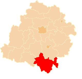
Blok Dobryszyce is a village in the administrative district of Gmina Dobryszyce, within Radomsko County, Łódź Voivodeship, in central Poland. It lies approximately 4 kilometres (2 mi) south-east of Dobryszyce, 7 km (4 mi) north of Radomsko, and 74 km (46 mi) south of the regional capital Łódź.
Borowiecko is a village in the administrative district of Gmina Dobryszyce, within Radomsko County, Łódź Voivodeship, in central Poland. It lies approximately 4 kilometres (2 mi) south-east of Dobryszyce, 8 km (5 mi) north of Radomsko, and 73 km (45 mi) south of the regional capital Łódź.
Dobryszyce is a village in Radomsko County, Łódź Voivodeship, in central Poland. It is the seat of the gmina called Gmina Dobryszyce. It lies approximately 10 kilometres (6 mi) north of Radomsko and 71 km (44 mi) south of the regional capital Łódź.
Galonki is a village in the administrative district of Gmina Dobryszyce, within Radomsko County, Łódź Voivodeship, in central Poland. It lies approximately 2 kilometres (1 mi) south of Dobryszyce, 9 km (6 mi) north-west of Radomsko, and 73 km (45 mi) south of the regional capital Łódź.
Rożny is a village in the administrative district of Gmina Dobryszyce, within Radomsko County, Łódź Voivodeship, in central Poland. It lies approximately 3 kilometres (2 mi) south-west of Dobryszyce, 9 km (6 mi) north-west of Radomsko, and 73 km (45 mi) south of the regional capital Łódź.
Ruda is a village in the administrative district of Gmina Dobryszyce, within Radomsko County, Łódź Voivodeship, in central Poland. It lies approximately 4 kilometres (2 mi) east of Dobryszyce, 9 km (6 mi) north of Radomsko, and 71 km (44 mi) south of the regional capital Łódź.
Żaby is a village in the administrative district of Gmina Dobryszyce, within Radomsko County, Łódź Voivodeship, in central Poland. It lies approximately 3 kilometres (2 mi) north of Dobryszyce, 13 km (8 mi) north of Radomsko, and 68 km (42 mi) south of the regional capital Łódź.
Zalesiczki is a village in the administrative district of Gmina Dobryszyce, within Radomsko County, Łódź Voivodeship, in central Poland. It lies approximately 3 kilometres (2 mi) north of Dobryszyce, 12 km (7 mi) north of Radomsko, and 69 km (43 mi) south of the regional capital Łódź.
Aleksandrów is a village in the administrative district of Gmina Kamieńsk, within Radomsko County, Łódź Voivodeship, in central Poland. It lies approximately 4 km (2 mi) north of Kamieńsk, 19 km (12 mi) north of Radomsko, and 62 km (39 mi) south of the regional capital Łódź.
Biestrzyków Wielki is a village in the administrative district of Gmina Kobiele Wielkie, within Radomsko County, Łódź Voivodeship, in central Poland. It lies approximately 7 kilometres (4 mi) north-east of Kobiele Wielkie, 17 km (11 mi) east of Radomsko, and 80 km (50 mi) south of the regional capital Łódź.
Przydatki Przybyszowskie is a village in the administrative district of Gmina Kobiele Wielkie, within Radomsko County, Łódź Voivodeship, in central Poland. It lies approximately 2 kilometres (1 mi) north-east of Kobiele Wielkie, 13 km (8 mi) east of Radomsko, and 82 km (51 mi) south of the regional capital Łódź.
Hamborowa is a village in the administrative district of Gmina Kodrąb, within Radomsko County, Łódź Voivodeship, in central Poland. It lies approximately 2 kilometres (1 mi) north of Kodrąb, 13 km (8 mi) north-east of Radomsko, and 76 km (47 mi) south of the regional capital Łódź.
Klizin is a village in the administrative district of Gmina Kodrąb, within Radomsko County, Łódź Voivodeship, in central Poland. It lies approximately 5 kilometres (3 mi) north of Kodrąb, 15 km (9 mi) north-east of Radomsko, and 73 km (45 mi) south of the regional capital Łódź.
Lipowczyce is a village in the administrative district of Gmina Kodrąb, within Radomsko County, Łódź Voivodeship, in central Poland. It lies approximately 6 kilometres (4 mi) north of Kodrąb, 17 km (11 mi) north-east of Radomsko, and 72 km (45 mi) south of the regional capital Łódź.
Żencin is a village in the administrative district of Gmina Kodrąb, within Radomsko County, Łódź Voivodeship, in central Poland. It lies approximately 6 kilometres (4 mi) north-east of Kodrąb, 18 km (11 mi) north-east of Radomsko, and 72 km (45 mi) south of the regional capital Łódź.
Wola Przedborska is a village in the administrative district of Gmina Przedbórz, within Radomsko County, Łódź Voivodeship, in central Poland. It lies approximately 2 kilometres (1 mi) north of Przedbórz, 31 km (19 mi) east of Radomsko, and 82 km (51 mi) south of the regional capital Łódź.
Zuzowy is a village in the administrative district of Gmina Przedbórz, within Radomsko County, Łódź Voivodeship, in central Poland. It lies approximately 9 kilometres (6 mi) north-east of Przedbórz, 37 km (23 mi) east of Radomsko, and 81 km (50 mi) south-east of the regional capital Łódź.