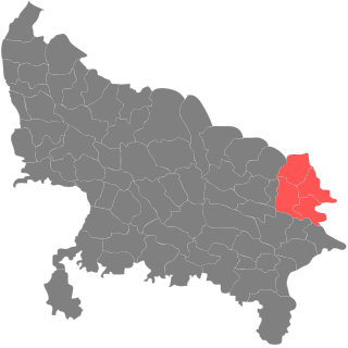
Gorakhpur division is an administrative geographical unit of Uttar Pradesh state in northern India. Gorakhpur is the administrative headquarters of the division. Currently (2017), the division consists of four districts:

Jedlińsk is a town in Radom County, Masovian Voivodeship, in east-central Poland. It is the seat of the gmina called Gmina Jedlińsk. It lies in historic Lesser Poland, approximately 14 kilometres (9 mi) north of Radom and 79 km (49 mi) south of Warsaw along the E77 Highway. The village has an approximate population of 1,700.
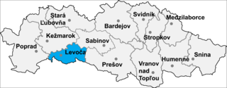
Harakovce is a village and municipality in Levoča District in the Prešov Region of central-eastern Slovakia.

George Street tram stop is a tram stop in Croydon. It is one of the busiest stops on the line as it is the most centrally located stop for the main shopping areas. It is almost directly outside the former Allders store and is on the site of the Park Place proposed development. Tramlink trams serve the stop, where trams depart in a westbound direction only.
Różana is a village in the administrative district of Gmina Udanin, within Środa Śląska County, Lower Silesian Voivodeship, in south-western Poland. Prior to 1945 it was in Germany.
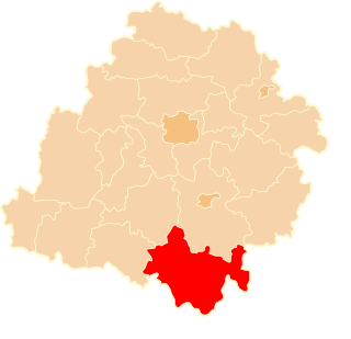
Białek is a village in the administrative district of Gmina Gorzkowice, within Piotrków County, Łódź Voivodeship, in central Poland. It lies approximately 4 kilometres (2 mi) south-east of Gorzkowice, 23 km (14 mi) south of Piotrków Trybunalski, and 66 km (41 mi) south of the regional capital Łódź.
Małyń is a village in the administrative district of Gmina Zadzim, within Poddębice County, Łódź Voivodeship, in central Poland. It lies approximately 13 kilometres (8 mi) east of Zadzim, 14 km (9 mi) south of Poddębice, and 31 km (19 mi) west of the regional capital Łódź.
Besiekierz Nawojowy is a village in the administrative district of Gmina Zgierz, within Zgierz County, Łódź Voivodeship, in central Poland. It lies approximately 13 kilometres (8 mi) north of Zgierz and 19 km (12 mi) north of the regional capital Łódź.
Besiekierz Rudny is a village in the administrative district of Gmina Zgierz, within Zgierz County, Łódź Voivodeship, in central Poland. It lies approximately 12 kilometres (7 mi) north of Zgierz and 19 km (12 mi) north of the regional capital Łódź.
Dąbrówka-Strumiany is a village in the administrative district of Gmina Zgierz, within Zgierz County, Łódź Voivodeship, in central Poland. It lies approximately 4 kilometres (2 mi) north of Zgierz and 12 km (7 mi) north of the regional capital Łódź.
Jedlicze B is a village in the administrative district of Gmina Zgierz, within Zgierz County, Łódź Voivodeship, in central Poland. It lies approximately 9 kilometres (6 mi) west of Zgierz and 15 km (9 mi) north-west of the regional capital Łódź.
Nowe Łagiewniki is a village in the administrative district of Gmina Zgierz, within Zgierz County, Łódź Voivodeship, in central Poland. It lies approximately 3 kilometres (2 mi) east of Zgierz and 8 km (5 mi) north of the regional capital Łódź.
Osmolin is a village in the administrative district of Gmina Zgierz, within Zgierz County, Łódź Voivodeship, in central Poland.
Rogóźno is a village in the administrative district of Gmina Zgierz, within Zgierz County, Łódź Voivodeship, in central Poland. It lies approximately 14 kilometres (9 mi) north of Zgierz and 21 km (13 mi) north of the regional capital Łódź.
Stefanów is a village in the administrative district of Gmina Zgierz, within Zgierz County, Łódź Voivodeship, in central Poland.
Wiktorów is a village in the administrative district of Gmina Zgierz, within Zgierz County, Łódź Voivodeship, in central Poland. It lies approximately 11 kilometres (7 mi) north-west of Zgierz and 19 km (12 mi) north-west of the regional capital Łódź.
Sakimori Station is a train station in Muroran, Hokkaidō, Japan.
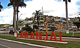
Laranjal, Minas Gerais is a municipality in the state of Minas Gerais in the Southeast region of Brazil.
Highwood is a village and civil parish in the Chelmsford District of Essex, England. The village is approximately a mile south from the A414 road and four miles west from the centre of the county town of Chelmsford. Loves Green is part of the village at its north. The hamlet of Edney Common is at the east of the parish.
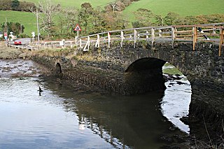
Terras Bridge is a road bridge across the River Looe in Cornwall, England, UK.