Kinshasa, formerly Léopoldville, is the capital and largest city of the Democratic Republic of the Congo. Once a site of fishing and trading villages situated along the Congo River, Kinshasa is now one of the world's fastest growing megacities.

Brazzaville is the capital and largest city of the Republic of the Congo. Constituting the financial and administrative centre of the country, it is located on the north side of the Congo River, opposite Kinshasa, the capital city of the Democratic Republic of the Congo.

The Democratic Republic of the Congo (DRC), also known as Congo-Kinshasa and formerly known as Zaire, is a country in Central Africa bordered to the west by the South Atlantic Ocean. By land area, the DRC is the second-largest country in Africa and the 11th-largest in the world. With a population of around 112 million, the Democratic Republic of the Congo is the most populous officially Francophone country in the world. The national capital and largest city is Kinshasa, which is also the nation's economic center. The country is bordered by the Republic of the Congo, Central African Republic, South Sudan, Uganda, Rwanda, Burundi, Tanzania, Zambia, Angola, and the Cabinda exclave of Angola.
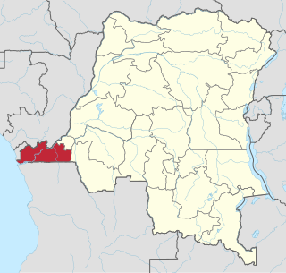
Kongo Central, formerly Bas-Congo is one of the 26 provinces of the Democratic Republic of the Congo. Its capital is Matadi.

Bandundu is one of eleven former provinces of the Democratic Republic of the Congo. It bordered the provinces of Kinshasa and Bas-Congo to the west, Équateur to the north, and Kasai-Occidental to the east. The provincial capital is also called Bandundu.
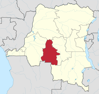
Kasaï-Occidental was one of the eleven provinces of the Democratic Republic of the Congo between 1966 and 2015, when it was split into the Kasaï-Central and the Kasaï provinces.

Bukavu is a city in eastern Democratic Republic of the Congo (DRC), lying at the extreme south-western edge of Lake Kivu, west of Cyangugu in Rwanda, and separated from it by the outlet of the Ruzizi River. It is the capital of the South Kivu province and as of 2012 it had an estimated population of 806,940.
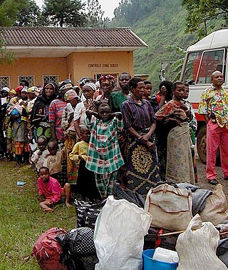
The Second Congo War, also known as the Great War of Africa or the Great African War and sometimes referred to as the African World War, began in the Democratic Republic of the Congo in August 1998, little more than a year after the First Congo War, and involved some of the same issues. The war officially ended in July 2003, when the Transitional Government of the Democratic Republic of the Congo took power. Although a peace agreement was signed in 2002, violence has continued in many regions of the country, especially in the east. Hostilities have continued since in the ongoing Lord's Resistance Army insurgency, and the Kivu and Ituri conflicts. Nine African countries and around twenty-five armed groups became involved in the war.

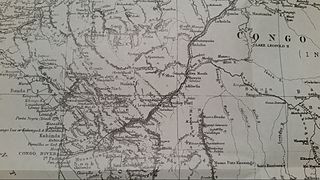
Kivu was the name for a large "region" in the Democratic Republic of the Congo under the rule of Mobutu Sese Seko that bordered Lake Kivu. It included three "Sub-Regions" : Nord-Kivu, Sud-Kivu and Maniema, corresponding to the three current provinces created in 1986. The capital of the Kivu Region was in Bukavu, and the capitals of the three Sub-Regions were in Goma, Uvira and Kindu.

Bandundu, formerly known as Banningville or Banningstad, is the capital city of Kwilu Province of the Democratic Republic of the Congo.

Kindu is a city in the Democratic Republic of Congo, the capital of Maniema province. It has a population of about 200,000 and is situated on the Lualaba River at an altitude of about 500 metres, and is about 400 km west of Bukavu.

The National Assembly is the lower house and main legislative political body of the Parliament of the Democratic Republic of the Congo. It was established by the 2006 constitution.

The Republic of the Congo, also known as Congo-Brazzaville, the Congo Republic or simply either Congo or the Congo, is a country located on the western coast of Central Africa to the west of the Congo River. It is bordered to the west by Gabon, to its northwest by Cameroon and its northeast by the Central African Republic, to the southeast by the Democratic Republic of the Congo, to its south by the Angolan exclave of Cabinda and to its southwest by the Atlantic Ocean.
Bolobo is a town on the Congo River in Mai-Ndombe Province in the western part of the Democratic Republic of the Congo (DRC). It is the administrative center of Bolobo Territory. As of 2009 it had an estimated population of 31,366.
Bongandanga is a small town in Mongala Province in the northwestern part of the Democratic Republic of the Congo. In 2009, it had an estimated population of 4625. It is the administrative center of the Bongandanga Territory.
Gory Gopela is a rural commune and small town and in the Cercle of Kayes in western Mali. In 2009 it had a total population of 7,712, with around 3,600 people in the main town.
Kasongo, also known as Piani Kasongo, is a town and a Territory, located in the Maniema Province of the eastern Democratic Republic of the Congo.
Noqui is a town and municipality in Zaire Province in Angola. It is on the Congo River, just across the border from the city of Matadi in the Democratic Republic of the Congo. The municipality had a population of 23,880 in 2014.
Lombo is a community in the Bosobolo territory of Nord-Ubangi province in the extreme northwest of the Democratic Republic of the Congo. It is served by the small Lombo Airport.
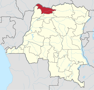
Nord-Ubangi is one of the 21 new provinces of the Democratic Republic of the Congo created in the 2015 repartitioning. Nord-Ubangi, Équateur, Mongala, Sud-Ubangi, and Tshuapa provinces are the result of the dismemberment of the former Équateur province.