
Walton is a village and civil parish in the City of Wakefield in the county of West Yorkshire, England, 4 miles south-east of Wakefield. At the time of the 2011 Census, the parish had a population of 3,231. At the time of the 2011 Census the parish was part of the City of Wakefield's ward of Crofton, Ryhill and Walton. The population of this ward at the Census was 15,144.

The Aire and Calder Navigation is the canalised section of the Rivers Aire and Calder in West Yorkshire, England. The first improvements to the rivers above Knottingley were completed in 1704 when the Aire was made navigable to Leeds and the Calder to Wakefield, by the construction of 16 locks. Lock sizes were increased several times, as was the depth of water, to enable larger boats to use the system. The Aire below Haddlesey was bypassed by the opening of the Selby Canal in 1778. A canal from Knottingley to the new docks and new town at Goole provided a much shorter route to the River Ouse from 1826. The New Junction Canal was constructed in 1905, to link the system to the River Don Navigation, by then part of the Sheffield and South Yorkshire Navigation.

Wakefield is a cathedral city in West Yorkshire, England located on the River Calder. The city had a population of 109,766 in the 2021 census, up from 99,251 in the 2011 census. The city is the administrative centre of the wider Metropolitan Borough of Wakefield, which had a 2022 population of 357,729, the 26th most populous district in England. It is part of the West Yorkshire Built-up Area and the Yorkshire and The Humber region.

Nostell is an estate about 4 miles ESE of Wakefield the City of Wakefield in West Yorkshire, England. It is in the civil parish of Huntwick with Foulby and Nostell which had a population of 90 in 2001, and 164 at the 2011 census.

Rothwell is a town in the south-east of the City of Leeds metropolitan borough in West Yorkshire, England, situated between Leeds and Wakefield. It is located in the eponymous Rothwell ward of Leeds City Council and Elmet and Rothwell parliamentary constituency, and is part of the West Yorkshire Urban Area.

Wakefield, also known as the City of Wakefield, is a local government district with city status and a metropolitan borough in West Yorkshire, England. Wakefield, the largest settlement, is the administrative centre of the district. The population of the City of Wakefield at the 2011 Census was 325,837.

Stanley is a village in the Metropolitan Borough of Wakefield in West Yorkshire, England. It is about 2.5 miles (4.0 km) north-east of Wakefield city centre. Stanley was an Urban District in the West Riding of Yorkshire before 1974, being made up the four electoral wards of Lake Lock, Outwood, Stanley and Wrenthorpe. The Lofthouse / Stanley area of West Yorkshire has a combined population of 22,947. The ward remaining at the 2011 Census was called Stanley and Outwood East. The population of this ward at the 2011 Census was 15,314.

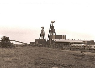
Caphouse Colliery, originally known as Overton Colliery, was a coal mine in Overton, near Wakefield, West Yorkshire, England. It was situated on the Denby Grange estate owned by the Lister Kaye family, and was worked from the 18th century until 1985. It reopened as the Yorkshire Mining Museum in 1988, and is now the National Coal Mining Museum for England.

Netherton is a village in the City of Wakefield metropolitan borough of West Yorkshire, England. It lies about 4 miles south-west of Wakefield, 3 miles south of Ossett and 1 mile south of Horbury. The village is in the Wakefield Rural ward of Wakefield Metropolitan District Council. The village name is shown on map "Dvcatvs Eboracensis pars occidentalis" from 1646.

Outwood is a district to the north of Wakefield, in West Yorkshire, England. The district is centred on the A61 Leeds Road south of Lofthouse. It grew up as a pit village and was only a small settlement until the 1970s, when construction of new houses caused it to grow and merge with neighbouring settlements such as Wrenthorpe and Stanley. In 2001, it had a population of 7,623.

Micklefield is a village and civil parish in the City of Leeds in West Yorkshire, England. It neighbours Garforth, Aberford and Brotherton and is close to the A1(M) motorway. The population as of the 2011 Census was 1,893, increased from 1,852 in 2001.
Silverwood Colliery was a colliery situated between Thrybergh and Ravenfield in Yorkshire, England. Originally called Dalton Main, it was renamed after a local woodland. It was owned by Dalton Main Collieries Ltd.
The Lake Lock Rail Road was an early, approximately 3 miles (4.8 km) long, horse-drawn narrow gauge railway built near Wakefield, West Yorkshire, England. The railway is recognised as the world's first public railway, though other railway schemes around the same time also claim that distinction.
The South Yorkshire Coalfield is so named from its position within Yorkshire. It covers most of South Yorkshire, West Yorkshire and a small part of North Yorkshire. The exposed coalfield outcrops in the Pennine foothills and dips under Permian rocks in the east. Its most famous coal seam is the Barnsley Bed. Coal has been mined from shallow seams and outcrops since medieval times and possibly earlier.

The Lofthouse Colliery disaster was a mining accident in Lofthouse, in the West Riding of Yorkshire, England, on Wednesday 21 March 1973, in which seven mine workers died when workings flooded.

Selby coalfield was a large-scale deep underground mine complex based around Selby, North Yorkshire, England, with pitheads at Wistow Mine, Stillingfleet Mine, Riccall Mine, North Selby Mine, Whitemoor Mine and at Gascoigne Wood Mine. All coal was brought to the surface and treated at Gascoigne Wood before being distributed by rail. The primary purpose of the pit was to supply coal for electrical power generation; much of it was used in the nearby Aire valley power stations.

The River Calder is a river in West Yorkshire, in Northern England.
Thorne Colliery was a large colliery within the Metropolitan Borough of Doncaster, South Yorkshire in the South Yorkshire Coalfield.
The Hull and Doncaster Branch is a secondary main railway line in England, connecting Kingston upon Hull to South Yorkshire and beyond via a branch from the Selby Line near Gilberdyke to a connection to the Doncaster–Barnetby line at a junction near Thorne 8 miles north-east of Doncaster.

