Boulevard Mortier

Last updated

Boulevard Mortier
P1120202 Paris XX boulevard Mortier T3b rwk.JPG
Paris department land cover location map.svg
Reddot.svg
Shown within Paris
Length1,350 m (4,430 ft)
Width37.50 m (123.0 ft) to 40 m (130 ft)
Arrondissement 20th
Quarter Charonne
Coordinates 48°52′15″N2°24′31″E / 48.870833°N 2.408611°E / 48.870833; 2.408611
From Porte de Bagnolet
To Porte des Lilas, Paris
Construction
Completion1863
Denomination2 March 1864

The Boulevard Mortier is a boulevard in the 20th arrondissement of Paris, France. [1] It is one of the Boulevards of the Marshals, which circle the outer parts of the city.

Contents

Route

The boulevard starts at Porte de Bagnolet and ends at Porte des Lilas, [1] where it is continued by boulevard Sérurier. The housing estate Campagne à Paris  [ fr ] is located on the west side, near Porte de Bagnolet.

The boulevard was accessible through the Petite Ceinture bus line. Now it can be reached through the Métro Line 3.

History

A portion of the Thiers wall, the military structure and moat that later was replaced by the various Boulevards of the Marshals. Fortifications de la porte de Versailles (Paris).jpeg
A portion of the Thiers wall, the military structure and moat that later was replaced by the various Boulevards of the Marshals.

The French war department had completed the Thiers wall  including fortifications, a dry moat, a Rue Militaire and a large berm around 1840. In 1859, the military engineering service gave conditional control to the Paris city council. [2] The expansion of the land area of Paris in 1860, by annexing bordering communities, created a situation where everything within the Thiers wall was Paris and everything without was not. The Thiers wall, with its accompanying berm and moat, led to a profound disruption and complication of the synergistic relationship between Paris and its suburbs. Paris city council started upgrading and conversion of some sections of the Rue Militaire into boulevards in 1861, with the (yet unnamed) Boulevard de Mortier one of the first stretches to open.

In 1864, the boulevard was named after Édouard Mortier (1768–1835), Duke of Trévise and Marshal of France. [1]

Each section of the upgraded Rue Militaire was then named for a marshal of the First French Empire (1804–1814) who served under Napoleon I, leading to the entire ring being collectively called the Boulevards of the Marshals. [1] The Boulevards of the Marshals concept was almost fully realized by 1932, though the final three sections, closing the ring, would not be completed until 2005. Of the 22 boulevards, 19 have been named for Mortier or one of his fellow First Empire marshals.

Important building

Related Research Articles

<span class="mw-page-title-main">Boulevard Périphérique</span> Ring road

The Boulevard Périphérique, often called the Périph, is a controlled-access dual-carriageway ring road in Paris, France. With a few exceptions, it is situated along Paris's administrative limit.

<span class="mw-page-title-main">Belleville station (Paris Métro)</span> Metro station in Paris, France

Belleville is a station on Paris Métro Line 2 and Line 11. The station is in the district of Belleville at the corner of the 10th, 11th, 19th and 20th arrondissements.

<span class="mw-page-title-main">Gambetta station</span> Metro station in Paris, France

Gambetta is a station of the Paris Métro. It serves Line 3 and is the southern terminus of Line 3bis. Its located in the 20th arrondissement of Paris.

<span class="mw-page-title-main">Porte de Bagnolet station</span> Metro station in Paris, France

Porte de Bagnolet is a station on Paris Métro Line 3, located in the 20th arrondissement of Paris.

<span class="mw-page-title-main">Gallieni station</span> Metro station in Paris, France

Gallieni is a station on Paris Métro Line 3, being its eastern terminus. It is next door to a large international bus station serving bus services from Eurolines.

<span class="mw-page-title-main">Porte des Lilas station</span> Metro station in Paris, France

Porte des Lilas is a station of the Paris Métro. It serves line 11 and is the northern terminus of line 3bis. Located on the edge of the 19th and 20th arrondissements of Paris, it serves the neighborhood of the Porte des Lilas. The station is named after the nearby Porte des Lilas, a gate in the nineteenth century Thiers Wall of Paris, which led to the town of Les Lilas.

<span class="mw-page-title-main">Porte d'Italie station</span> Metro station in Paris, France

Porte d'Italie is a station on line 7 of the Paris Métro, and a stop on tramway T3a in the 13th arrondissement. It is named after the Porte d'Italie, a gate in the 19th century Thiers wall of Paris, which led to the south and Italy.

<span class="mw-page-title-main">Île-de-France tramway Lines 3a and 3b</span>

Île-de-France tramway Lines 3a and 3b are the first modern tramway in Paris proper since the 1937 closure of the previous comparable system. They are operated by the RATP and divided into two sections called T3a and T3b. The line is also known as the Tramway des Maréchaux because it follows the Boulevards of the Marshals, a series of boulevards that encircle Paris along the route of the former Thiers Wall. The boulevards are, with three exceptions, named for Napoleon's First Empire marshals (maréchaux); they were transformed by redevelopment works carried out during the two and a half year construction of the line, which opened on 16 December 2006 under the designation T3.

<span class="mw-page-title-main">Boulevards of Paris</span> Thoroughfare in Paris, France

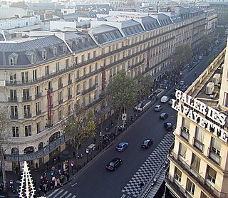
The Boulevards of Paris are boulevards which form an important part of the urban landscape of Paris. The boulevards were constructed in several phases by central government initiative as infrastructure improvements, but are very much associated with strolling and leisurely enjoyment in the minds of Parisians.

<span class="mw-page-title-main">Boulevards of the Marshals</span> Thoroughfare in Paris, France

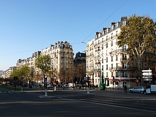
The Boulevards of the Marshals are a collection of thoroughfares that encircle the city of Paris, France, just inside its city limits. Most bear the name of a marshal of the First French Empire (1804–1814) who served under Napoleon I. The Île-de-France tramway Lines 3a and 3b today run on the Boulevards of the Marshals.

<span class="mw-page-title-main">City gates of Paris</span>

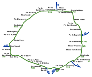
While Paris is encircled by the Boulevard Périphérique, the city gates of Paris are the access points to the city for pedestrians and other road users. As Paris has had successive ring roads through the centuries, city gates are found inside the modern-day Paris.
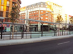
<span class="mw-page-title-main">Porte de Clichy station</span> Paris Metro station

Porte de Clichy is a station on Line 13 and Line 14 of the Paris Métro and RER C, as well as a stop on Île-de-France tramway Line 3b. Located in the 17th arrondissement, the Métro station is situated on the northwestern branch of Line 13, under the Avenue de Clichy. It serves the Tribunal de grande instance de Paris. The station is named after the Porte de Clichy, a gate in the nineteenth century Thiers wall of Paris, which led to Clichy.

<span class="mw-page-title-main">City walls of Paris</span>

The city walls of Paris refers to the city walls that surrounded Paris, France, as it grew from ancient times until the 20th century, built primarily to defend the city but also for administrative reasons. Several successive city walls were built over the centuries, either adding to existing walls or replacing demolished ones, through 1846, when construction of the Thiers wall was completed.

<span class="mw-page-title-main">Thiers wall</span> Former defensive wall in Paris

The Thiers wall was the last of the defensive walls of Paris. It was an enclosure constructed between 1841 and 1846 and was proposed by the French prime minister Adolphe Thiers but was actually implemented by his successor. The 33 kilometres (21 mi) long wall and ditch made a complete circuit around the city as it stood at the time of the July Monarchy. It was bombarded by the Prussian Army during the Franco-Prussian War, captured by government troops during the Paris Commune and refortified at the start of the First World War. However, by then it had become obsolete as a fortification, was a barrier to the expansion of the city, and the area immediately outside of it, known as "the zone", had become a shanty town. The wall was demolished in the interwar period; its path today can be traced by the Boulevards of the Marshals which originally ran just behind the fortifications and by the Boulevard Périphérique which was later built just outside. A few remnants of the wall can still be seen.

<span class="mw-page-title-main">Porte de Vincennes</span>

The Porte de Vincennes is one of the city gates of Paris (France) situated in the Bel Air neighborhood of the 12th arrondissement.

<span class="mw-page-title-main">Boulevard de l'Amiral-Bruix</span>

The Boulevard de l'Amiral-Bruix is a boulevard in the 16th arrondissement of Paris, France. It is one of the Boulevards of the Marshals that circle the outer parts of the city.

<span class="mw-page-title-main">Outline of Paris</span> Overview of and topical guide to Paris

The following outline is provided as an overview of and topical guide to Paris:

<span class="mw-page-title-main">Boulevard Poniatowski</span> Street in Paris, France

The Boulevard Poniatowski is a boulevard in the Bel-Air, Picpus and Bercy neighborhoods in the 12th arrondissement of Paris, France. It is one of the Boulevards of the Marshals that run in the outer parts of the city.

<span class="mw-page-title-main">Boulevard Lefebvre</span> Street in Paris, France

The Boulevard Lefebvre is a boulevard in the Saint-Lambert quarter in the 15th arrondissement of Paris, France. It is one of the Boulevards of the Marshals, which run in the outer parts of the city.

<span class="mw-page-title-main">Boulevard Soult</span> Street in Paris, France

The Boulevard Soult is a boulevard in the Bel-Air neighborhood in the 12th arrondissement of Paris, France. It is one of the Boulevards of the Marshals that run in the outer parts of the city.

References

  1. 1 2 3 4 "Extrait de la nomenclature officielle des voies de Paris – Boulevard MORTIER". www.v1.paris.fr (in French). Archived from the original on 22 November 2006. Retrieved 9 April 2019.
  2. Deville, A. (Adrien); Hochereau, (Émile) (1886). "Rue Militaire (28 juillet 1859)". In Alphand, Monsieur (Jean-Charles Adolphe) (ed.). Ville de Paris : Recueil des Lettres Patentes, Ordonnances Royales, Décrets et Arrêtés Préfectoraux Concernant les Voies Publiques [City of Paris. Collection of letters patents, royal ordinances, decrees and prefectores relating to public roads.] (in French). Paris: Imprimerie Nouvelle (Association Ouvrière). pp. 314–315. Retrieved 12 August 2020.
  3. "Quand la colère monte… à Ménilmontant". parisrevolutionnaire.com (in French). 15 June 2013. Retrieved 23 December 2014.
  4. "Boulevard Mortier, devant l'immeuble de Jacques Duclos…". L'Humanité (in French). 7 July 1990.
  5. Jacques Follorou; Franck Johannès (4 July 2013). "Révélations sur le Big Brother français". Le Monde (in French).