
Traboules are a type of secret covered passageways primarily associated with the city of Lyon, France, but also located in the French cities of Villefranche-sur-Saône, Mâcon, Saint-Étienne, along with a few in Chambéry). In Lyon, they were originally used by silk manufacturers and other merchants to transport their products.
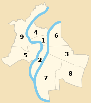
The nine arrondissements of Lyon are the administrative divisions of the City of Lyon. Unlike the spiral pattern of the arrondissements of Paris, or the meandering pattern of those in Marseille, the layout in Lyon is more idiosyncratic. This is for historical reasons: following the annexation of the communes of La Guillotière, La Croix-Rousse and Vaise in 1852, the newly enlarged city was divided into 5 arrondissements, which originally spiralled out anticlockwise from the Hôtel de Ville ; however, as the city's population expanded, it became necessary to split certain arrondissements, giving rise to today's seemingly random pattern.

Lyon, traditionally spelled in English as Lyons, is the third-largest city of France. It is located at the confluence of the rivers Rhône and Saône, to the northwest of the French Alps, 391 km (243 mi) southeast of Paris, 278 km (173 mi) north of Marseille, 113 km (70 mi) southwest of Geneva, 58 km (36 mi) northeast of Saint-Étienne.

La Croix-Rousse is a hill 254 metres (833 ft) high in the city of Lyon, France, as well as the name of a neighborhood located on this hill. The neighborhood is divided into les pentes and le plateau. This zone is served by Lyon Metro Line C. With 18th century architecture, including unique dwellings for labourers, La Croix-Rousse was inscribed on the UNESCO World Heritage List in 1998 to protect Lyon's long history as an important European city.

The 1st arrondissement of Lyon, France is one of the nine arrondissements of the City of Lyon. It is located below the hill of Croix-Rousse and on the north part of the Presqu'île formed by the Saône and the Rhône, the two rivers in Lyon.
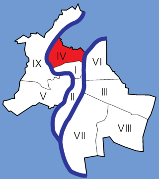
The 4th arrondissement of Lyon is one of the nine arrondissements of the City of Lyon.

The Tunnel de la Croix-Rousse is a pair of two tunnels located in the 1st and 4th arrondissements of Lyon, a road tunnel opened to traffic on 19 April 1952 and a sustainable transport tunnel opened in 2013.

The Église du Bon-Pasteur is a Roman Catholic church located at rue Neyret on the slopes of La Croix-Rousse, near the montée de la Grande Côte, in the 1st arrondissement of Lyon. Cardinal Barbarin described the church as "highly symbolic for Lyon Christians".

The Place Sathonay is a square located in the 1st arrondissement of Lyon, France, at the bottom of hill of La Croix-Rousse, in La Martinière quarter. It was named after Nicolas-Marie-Jean-Claude Fay de Sathonay, mayor of Lyon from 1805 to 1812, as a tribute for all the importants works undertaken under his presidency. The square is currently the third largest square in Lyon and belongs to the zone classified as World Heritage Site by UNESCO. According to Lyon geography agrégé Jean Pelletier, it is "one of the most interesting squares of Lyon", because of its harmonious proportions, its boundaries composed of buildings with beautiful 1920s facades, and its plantations, which brings "a charm tinged of poetry" and give it the appearance of a village square.

The Église Saint-Polycarpe is a Roman Catholic church located in the 1st arrondissement of Lyon, on the slopes of La Croix-Rousse, between rue René Leynaud, rue Burdeau and passages Mermet and Thiaffait. It is the oldest church of the Oratory of Saint Philip Neri.
The Montée des Carmélites is one of the oldest streets of Lyon, dating from Roman times, located in the 1st arrondissement of Lyon. It connects the Saint-Vincent quarter to the Plateau de la Croix-Rousse. It is situated between the rue de la Tourette and the rue Ray Fernand, and ends at the intersection of the rue Burdeau, rue du Jardin des Plantes and rue de l'Annonciade.

The Cour des Voraces, also called Maison de la République, is a courtyard building in the Pentes quarter, in the 1st arrondissement of Lyon, famous for its enormous six-floor stairway. It is an impressive traboule, a covered passage with entrances on Place Colbert, Montée Saint-Sébastien and Rue Imbert-Colomès.
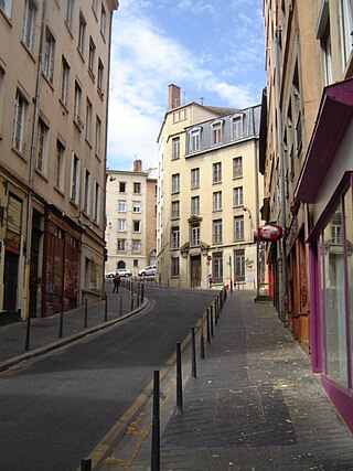
The rue Sainte-Catherine is a very old street at the foot of the slopes of La Croix-Rousse quarter, in the 1st arrondissement of Lyon. It is particularly known for being a drinking street. The street belongs to the zone classified as World Heritage Site by UNESCO.

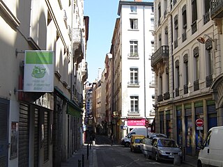
The Rue Royale is a street located in the 1st arrondissement of Lyon and was the main street of the quarter when it was created. It starts between the Place Servetus and the Rue de Provence and ends by joining the Grande Rue des Feuillants. There are many traboules closed which link the street with the Quai Lassagne and the rue d'Alsace-Lorraine. It is served by line C of the metro.
The Rue d'Austerlitz is a street in the 4th arrondissement of Lyon, in La Croix-Rousse quarter. It begins on the rue du Mail, at the corner of Place de la Croix-Rousse, crosses the rue du Pavilion, the rue de Belfort and the rue Aimé Boussange, and ends on Place Bellevue. Its name refers to the Battle of Austerlitz, one of the greatest victories of Napoleon. There are metro and velo'v stations.

The Rue Dumenge is a street located in the 4th arrondissement of Lyon, in the quarter of La Croix-Rousse. It begins on the rue du Mail, crosses the rue du Pavillon and the rue de Belfort and ends on the rue Dumont-d'Urville. The street is served by a metro station of the line C and a velo'v station.

The Place Croix-Paquet is a square located in the 1st arrondissement of Lyon, in the pentes de la Croix-Rousse quarter. It is formed by the intersection of the rue du Griffon, the rue des Capucins and the montée Saint-Sébastien. The square belongs to the zone classified World Heritage Site by UNESCO.
The following is a timeline of the history of the city of Lyon, France.

Gros Caillou is a landmark of the French city of Lyon in the neighborhood Croix-Rousse. The rock's mineralogical composition suggests it is a glacial erratic, and would have been transported from the nearby Alps by slowly moving glaciers.
