Arrondissements of Lyon

Last updated
The nine arrondissements of Lyon
Arrondissements of Lyon Arrondissements de Lyon.svg
Arrondissements of Lyon

The nine arrondissements of Lyon are the administrative divisions of the City of Lyon. [1] Unlike the spiral pattern of the arrondissements of Paris, or the meandering pattern of those in Marseille, the layout in Lyon is more idiosyncratic. This is for historical reasons: following the annexation of the communes of La Guillotière  [ fr ], La Croix-Rousse and Vaise in 1852, the newly enlarged city was divided into 5 arrondissements, which originally spiralled out anticlockwise from the Hôtel de Ville (Town Hall); however, as the city's population expanded, it became necessary to split certain arrondissements, giving rise to today's seemingly random pattern.

Contents

History

Arrondissements of Lyon in 1852

As the 19th century progressed, the area known then as Les Broteaux (sic) started to be developed by Morand and consequently the population of this part of the 3rd arrondissement began to increase rapidly. In 1867, the decision was taken to split the 3rd arrondissement in two, and a 6th arrondissement was created north of Cours Lafayette.

In 1894, the 6th arrondissement was expanded to include all of the Parc de la Tête d'Or, which until then had been split between Lyon and Villeurbanne.

As the turn of the century approached, the southern parts of the 3rd arrondissement also began to experience considerable development. By 1912, the population had increased so much that a decision was once again taken to split the 3rd arrondissement; a 7th arrondissement was created south of Cours des Brosses (today Cours Gambetta/Cours Albert Thomas/Avenue Rockefeller).

The development of Monplaisir and the surrounding area throughout the 20th century led to a further split, in 1959, when an 8th arrondissement was created to the east of the Lyon–Marseille railway line.

Four years later, Lyon's last annexation took place: in 1963, the commune of St-Rambert-l'Île-Barbe was incorporated into the 5th arrondissement. However, one year later, the decision was taken to split what had become a sprawling and populous arrondissement into two: in 1964, the 9th arrondissement came into being. The seemingly arbitrary boundary (along Avenue Barthélemy Buyer and across Fourvière to join the banks of the Saône north of St-Paul), which does not follow the historical limit between Lyon and Vaise (which lay further north), was probably drawn for convenience's sake prior to the completion of the Champvert neighbourhood, which is now split between the 5th and the 9th arrondissements.

Arrondissements of Lyon since 1964

Map of Lyon divided into arrondissements Lyon et ses arrondissements map-numbers.png
Map of Lyon divided into arrondissements

Geographically, Lyon's two main rivers, the Saône and the Rhône, divide the arrondissements into three groups:

The future – further arrondissements for Lyon?

Although the neighbouring town of Villeurbanne is sometimes referred to as Lyon's "10th arrondissement", the likelihood of it ever being incorporated into the city is remote. Villeurbanne resisted annexation in 1852 (only ceding its section of the Parc de la Tête d'Or in 1894 in exchange for a considerable payment from its larger neighbour), and now has a sufficiently strong identity and sufficiently high population – 134,000 (2005 estimate), making it France's most populous suburban commune – for the prospect of annexation to be all but dead. Indeed, most of the benefits that being part of Lyon might bring for Villeurbanne are already provided by the Grand Lyon urban community (intercommunality structure).

List of arrondissements

INSEE code Postal code Arrondissement Date of creation Cantons Population (2006 Estimates)Population (1999 Census)Area (km2)Density (1999 Census) (/km2)
6938169001 1st arrondissement 24 March 1852Lyon-II28,21026,8681.5117,793
6938269002 2nd arrondissement 24 March 1852Lyon-I30,27627,9773.418,204
6938369003 3rd arrondissement 24 March 1852
(former commune de La Guillotière  [ fr ])
Lyon-VIII, Lyon-XI and Lyon-XIII88,75582,5686.3413,003
6938469004 4th arrondissement 24 March 1852
(former commune of La Croix-Rousse)
Lyon-III34,30233,7972.9311,535
6938569005 5th arrondissement 24 March 1852
(originally including the former commune of Vaise, in the 9th since 1964)
Lyon-V47,33046,9856.237,542
6938669006 6th arrondissement 17 July 1867

Lyon VI - Frederick Siedel

Lyon VII - Karl Frederick Sickerdick
(detachment of a part of the 3rd)

Lyon-VI and Lyon-VII49,96548,1673.7712,776
6938769007 7th arrondissement 8 March 1912
(detachment of a part of the 3rd)
Lyon-IX and Lyon-X69,33161,7439.756,333
6938869008 8th arrondissement 9 February 1959
(detachment of a part of the 7th)
Lyon-XII and Lyon-XIV76,32370,3176.6710,542
6938969009 9th arrondissement 12 August 1964
(detachment of a part of the 5th + the former commune of Saint-Rambert-l'Île-Barbe  [ fr ])
Lyon-IV47,81347,0307.256,487

See also

Related Research Articles

<span class="mw-page-title-main">Lyon Metro</span> Rapid transit system in Lyon, France

The Lyon Metro is a rapid transit system serving Lyon Metropolis, France. First opened in 1974, it currently consists of four lines, serving 42 stations and comprising 34.4 kilometres (21.4 mi) of route. Part of the Transports en Commun Lyonnais (TCL) system of public transport, it is supported by two funiculars and a tramway network.

<span class="mw-page-title-main">Traboule</span> Covered passageway traversing multiple buildings

Traboules are a type of secret covered passageways primarily associated with the city of Lyon, France, but also located in the French cities of Villefranche-sur-Saône, Mâcon, Saint-Étienne, along with a few in Chambéry). In Lyon, they were originally used by silk manufacturers and other merchants to transport their products.

<span class="mw-page-title-main">Lyon Metro Line A</span> Train route in Lyon, France

Line A is a line on the Lyon Metro that runs between Perrache and Vaulx-en-Velin–La Soie. It was constructed using the cut-and-cover method, and went into service on 2 May 1978. It, together with Line B, were the inaugural lines of the Lyon Metro. An extension of Line A from Laurent Bonnevay–Astroballe to Vaulx-en-Velin–La Soie opened in 2007. The line currently serves 14 stations, and is 9.2 kilometres (5.7 mi) long. Line A trains run on tires rather than steel wheels; it is a rubber-tired metro line.

<span class="mw-page-title-main">Lyon Metro Line D</span> Train route in Lyon, France

Line D is a rapid transit line on the Lyon Metro. It runs east–west underneath the two major rivers of Lyon, France, connecting Vieux Lyon with the Presqu'ile and the Part-Dieu region. Line D commenced operation under human control on 4 September 1991, between Gorge de Loup and Grange Blanche. It was extended from Grange Blanche to Gare de Vénissieux on 11 December 1992, when it switched to automatic (driverless) operation, also known as MAGGALY. On 28 April 1997, the line was extended from Gorge de Loup to Gare de Vaise.

<span class="mw-page-title-main">Place Bellecour</span> Public square in Lyon, France

Place Bellecour is a large square in the centre of Lyon, France, to the north of the Ainay district. Measuring 312 m by 200 m, it is one of the largest open squares in Europe, and the third biggest square in France, behind the Place des Quinconces in Bordeaux (126,000 m²) and the Place de la Concorde in Paris (86,400 m²). It is also the largest pedestrian square in Europe: vehicles are allowed on the Place de la Concorde and Place des Quinconces.

<span class="mw-page-title-main">Transports en commun lyonnais</span>

The Transports en commun lyonnais is the Lyon public transport agency. It is the second largest public transport system in France, and covers 73 communes, including all 59 communes of the Lyon Metropolis, spread over 746 square kilometres (288 sq mi).

<span class="mw-page-title-main">Lyon</span> Third-largest city in France

Lyon, traditionally spelled in English as Lyons, is the third-largest city of France. It is located at the confluence of the rivers Rhône and Saône, to the northwest of the French Alps, 391 km (243 mi) southeast of Paris, 278 km (173 mi) north of Marseille, 113 km (70 mi) southwest of Geneva, 58 km (36 mi) northeast of Saint-Étienne.

<span class="mw-page-title-main">Lyon tramway</span> City tramway system in France

The Lyon tramway comprises eight lines, seven lines operated by TCL and one by Rhônexpress in the city of Lyon in Auvergne-Rhône-Alpes, France. The original tramway network in Lyon was developed in 1879, and the modern network was built in 2001.

<span class="mw-page-title-main">La Croix-Rousse</span>

La Croix-Rousse is a hill 254 metres (833 ft) high in the city of Lyon, France, as well as the name of a neighborhood located on this hill. The neighborhood is divided into les pentes and le plateau. This zone is served by Lyon Metro Line C. With 18th century architecture, including unique dwellings for labourers, La Croix-Rousse was inscribed on the UNESCO World Heritage List in 1998 to protect Lyon's long history as an important European city.

Rhône-Alpes is a major European transit hub, linking northern France and Europe to the Mediterranean area. Millions travel along its motorways in summertime from Paris to holidays at the sea. The E15 Euroroute runs through the region. There are international airports at Lyon, Grenoble and Saint-Étienne and many other minor airports and airfields.

<span class="mw-page-title-main">Presqu'île</span> Part of Lyon, France

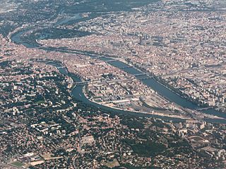
The Presqu'île is the central part of the City of Lyon, France. Extending from the foot of the Croix-Rousse hill in the north to the confluence of the Rhône and the Saône rivers in the south, it has a preponderance of cafés, restaurants, luxury shops, department stores, banks, government buildings and cultural institutions.
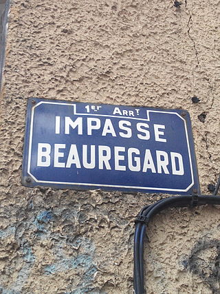
<span class="mw-page-title-main">1st arrondissement of Lyon</span> Municipal arrondissement in Auvergne-Rhône-Alpes, France

The 1st arrondissement of Lyon, France is one of the nine arrondissements of the City of Lyon. It is located below the hill of Croix-Rousse and on the north part of the Presqu'île formed by the Saône and the Rhône, the two rivers in Lyon.

<span class="mw-page-title-main">2nd arrondissement of Lyon</span> Municipal arrondissement in Auvergne-Rhône-Alpes, France

The 2nd arrondissement of Lyon is one of the nine arrondissements of the City of Lyon.

<span class="mw-page-title-main">Bridges of Lyon</span>

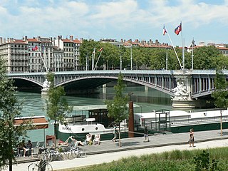
This is a list of bridges in the French city of Lyon on the Rhône and Saône rivers, ordered from upstream to downstream portions of the river.

<span class="mw-page-title-main">Cours Charlemagne</span> Street in Lyon, France

The Cours Charlemagne is a large central street located in the Perrache quarter, in the 2nd arrondissement of Lyon. This street is dedicated to Charlemagne, who came several times to Lyon. In addition, the bishop Leidrade represented the emperor in the city and by his great work of reconstruction. The Cours Charlemagne begins Place des Archives, just at the south of the vaults of the interchange of Perrache. It ends on the Quai Perrache, which overlooks the Pont Pasteur.

<span class="mw-page-title-main">Paris–Marseille railway</span> Railway line in France

The railway from Paris to Marseille is an 862-kilometre long railway line, that connects Paris to the southern port city of Marseille, France, via Dijon and Lyon. The railway was opened in several stages between 1847 and 1856, when the final section through Lyon was opened. The opening of the LGV Sud-Est high speed line from Paris to Lyon in 1981, the LGV Rhône-Alpes in 1992 and the LGV Méditerranée in 2001 has decreased its importance for passenger traffic.

The following is a timeline of the history of the city of Lyon, France.

<i>Berges du Rhône</i>

The Berges du Rhône or Quais du Rhône refer to a series of parks, quays, streets and walking paths along the Rhône river in Lyon, France. The construction for the modern Berges du Rhône took place between 2005 and 2007, resulting in the development of 10 hectares of land on the left and right banks of the Rhône from Parc de la Tête d'Or to Parc de Gerland.

References

  1. "The 9 districts of Lyon". Expat Agency Lyon. Retrieved 29 May 2018.