
The Stade de Gerland is a stadium in the city of Lyon, France, which serves as home to Top 14 rugby club Lyon OU. It has a seating capacity of 25,000.

Line B is a line on the Lyon Metro in France that runs between Charpennes–Charles Hernu and Saint-Genis-Laval–Hôpital Lyon Sud. It was constructed using the cut-and-cover method, and went into service on 2 May 1978. Together with Line A, it was one of the inaugural lines of the Lyon Metro. It has since been extended three times: from Part-Dieu to Jean Macé in 1981, from Jean Macé to Stade de Gerland in 2000, from Stade de Gerland to Oullins railway station in 2013 and to Saint-Genis-Laval–Hôpital Lyon Sud in 2023. The line serves 12 stations, and is 10.2 kilometres (6.3 mi) long. Line B trains run on tires rather than steel wheels; it is a rubber-tired metro line.
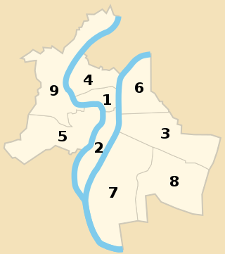
The nine arrondissements of Lyon are the administrative divisions of the City of Lyon. Unlike the spiral pattern of the arrondissements of Paris, or the meandering pattern of those in Marseille, the layout in Lyon is more idiosyncratic. This is for historical reasons: following the annexation of the communes of La Guillotière, La Croix-Rousse and Vaise in 1852, the newly enlarged city was divided into 5 arrondissements, which originally spiralled out anticlockwise from the Hôtel de Ville ; however, as the city's population expanded, it became necessary to split certain arrondissements, giving rise to today's seemingly random pattern.

Lyon is the second largest city in France and its third -largest city within city limits. It is located at the confluence of the rivers Rhône and Saône, to the northwest of the French Alps, 391 km (243 mi) southeast of Paris, 278 km (173 mi) north of Marseille, 113 km (70 mi) southwest of Geneva, Switzerland, 58 km (36 mi) northeast of Saint-Étienne.

The Lyon tramway comprises eight lines, seven lines operated by TCL and one by Rhônexpress, in the city of Lyon, France. The original tramway network in Lyon was developed in 1879; the modern network started operation in 2001.

The Boulevards of the Marshals are a collection of thoroughfares that encircle the city of Paris, France, just inside its city limits. Most bear the name of a marshal of the First French Empire (1804–1814) who served under Napoleon I. The Île-de-France tramway Lines 3a and 3b today run on the Boulevards of the Marshals.

The 3rd arrondissement of Lyon is one of the nine arrondissements of the City of Lyon.

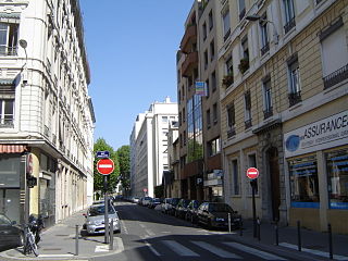
Avenue Berthelot is a street in the 7th (Guillotière) and 8th arrondissement (Bachut) of Lyon which connects the Galliéni bridge at the east to the A43 highway via the avenue Jean Mermoz which extends it to the west.

The 4th arrondissement of Lyon is one of the nine arrondissements of the City of Lyon.

The 5th arrondissement of Lyon is one of the nine arrondissements of the City of Lyon, France.

Lyon-Jean Macé station is a railway station in the 7th arrondissement of Lyon. It is situated on the Paris–Marseille railway and the Lyon–Geneva railway. The station is a part of the Lyon urban area rapid transit network. It was aimed to decongest the major stations Part-Dieu and Perrache while allowing access to the public transport of Lyon (TCL). The station began operation on 13 December 2009.
The city of Lyon and its urban area have several parks. The main parks in the inner city include Jardin des Chartreux in the 1st arrondissement, Parc Bazin, Parc Chambovet and Parc Sisley in the 3rd arrondissement, Parc de la Cerisaie, Parc Francis Popy and Jardin Rosa Mir in the 4th arrondissement, Jardin des Curiosités, Parc de la garde and Parc des Hauteurs in the 5th arrondissement, Parc de la Tête d'or in the 6th arrondissement, Parc de Gerland, Parc des berges du Rhône and Parc Sergent Blandan in the 7th arrondissement, and Parc de Montpellas, Parc Montel and Parc du Vallon in the 9th arrondissement.
The Rue Garibaldi is a wide and long street in Lyon, located in the 7th, 3rd and 6th arrondissements, and named after Italian politician Giuseppe Garibaldi. There was also a square named Place Garibaldi in reference to his nephews, died during the World War I.
La Rue de Créqui is a very long street located in the 7th, 3rd and 6th arrondissements of Lyon. It is a long straight line along the rue Duguesclin or the rue de Vendôme, that begins on the Grande Rue de la Guillotière in the 7th arrondissement and ends at the north in the 6th, on the Boulevard des Belges. It follows the Place Guichard, located in the 3rd arrondissement.
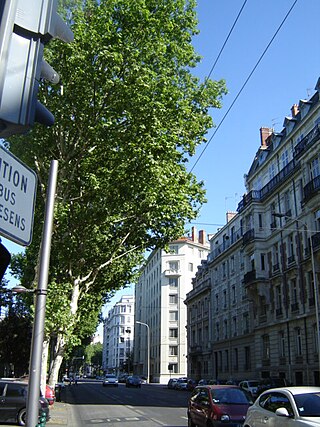
The Boulevard des Belges is a wide and posh avenue located in Les Brotteaux quarter, in the 6th arrondissement of Lyon. It begins with the Quai de Grande Bretagne, runs along the southern part of the Parc de la Tête d'Or until the Avenue Verguin and ends on the Place Jules Ferry, in front of the Gare des Brotteaux. The boulevard is lined with plane trees and is served by two velo'v stations and the line B of the metro.
The Rue Tronchet is a street located in the 6th arrondissement of Lyon, named after French jurist François Denis Tronchet (1726–1804).

The Rue de l'Université is a large street in the 7th arrondissement of Lyon which connects the Pont de l'Université and the Avenue Jean-Jaurès. It is extended to the east by the rue Marc Bloch then the route de Vienne. It was named after the presence of several university buildings, built at the end of the nineteenth century starting in 1884.

Place Jean-Macé is a plaza located in the 7th arrondissement of Lyon in France.

Parc Sergent Blandan, also shortened to Parc Blandan, is an urban park in the 7th arrondissement of Lyon in Lyon, France, adjacent to Cimetière de la Guillotière Ancien. With an area of 17 hectares, the park opened to the public on 13 September 2013 at the location of Caserne sergent Blandan, a military barracks previously known as "Fort Lamothe".


