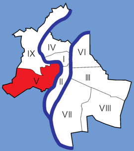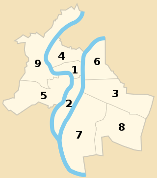
The nine arrondissements of Lyon are the administrative divisions of the City of Lyon. Unlike the spiral pattern of the arrondissements of Paris, or the meandering pattern of those in Marseille, the layout in Lyon is more idiosyncratic. This is for historical reasons: following the annexation of the communes of La Guillotière, La Croix-Rousse and Vaise in 1852, the newly enlarged city was divided into 5 arrondissements, which originally spiralled out anticlockwise from the Hôtel de Ville ; however, as the city's population expanded, it became necessary to split certain arrondissements, giving rise to today's seemingly random pattern.

Lyon is the second largest city in France and its third -largest city within city limits. It is located at the confluence of the rivers Rhône and Saône, to the northwest of the French Alps, 391 km (243 mi) southeast of Paris, 278 km (173 mi) north of Marseille, 113 km (70 mi) southwest of Geneva, Switzerland, 58 km (36 mi) northeast of Saint-Étienne.

Vieux Lyon is the largest Renaissance district of Lyon. In 1964, Vieux-Lyon, the city's oldest district, became the first site in France to be protected under the Malraux law to protect France's cultural sites. Covering an area of 424 hectares between the Fourvière hill and the river Saône, it is one of Europe's most extensive Renaissance neighborhoods. There are three distinct sections: Saint Jean, Saint Paul and Saint Georges. In 1998, Vieux Lyon was inscribed on the UNESCO World Heritage List along with other districts in Lyon because of its historical importance and architecture.

Pierre-Marie Bossan was a French historicist architect, a pupil of Henri Labrouste, specialising in ecclesiastical architecture.
The 1st arrondissement of Lyon is one of the nine arrondissements of the City of Lyon. It is located below the hill of Croix-Rousse and on the north part of the Presqu'île formed by the Saône and the Rhône, the two rivers in Lyon.

The 3rd arrondissement of Lyon is one of the nine arrondissements of the City of Lyon.

The 4th arrondissement of Lyon is one of the nine arrondissements of the City of Lyon.

The Église du Bon-Pasteur is a Roman Catholic church located at rue Neyret on the slopes of La Croix-Rousse, near the montée de la Grande Côte, in the 1st arrondissement of Lyon. Cardinal Barbarin described the church as "highly symbolic for Lyon Christians".

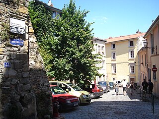
The Place de la Trinité is a square located in the 5th arrondissement of Lyon. The square, fully paved and surrounded by old buildings like the sun house, is more a crossing of small streets than a real square. It is on the hillside of Fourvière and is the low extremity of the hill of Gourguillon. The square is in the center of the zone classified as World Heritage Site by UNESCO.
La Rue de Créqui is a very long street located in the 7th, 3rd and 6th arrondissements of Lyon. It is a long straight line along the rue Duguesclin or the rue de Vendôme, that begins on the Grande Rue de la Guillotière in the 7th arrondissement and ends at the north in the 6th, on the Boulevard des Belges. It follows the Place Guichard, located in the 3rd arrondissement.

The Rue du Bœuf is a 188-metre cobbled pedestrian street of the Vieux Lyon quarter, located in the 5th arrondissement of Lyon. Very representative of the Renaissance architecture of the neighborhood, it is lined only with old houses from the 16th or 17th century. The street connects the rue de Gadagne which it continues after the Place du Petit Collège and the intersection of the rue du Chemin Neuf, the rue de la Bombarde and the rue Tramassac which prolongs it. The street belongs to the zone classified as World Heritage Site by UNESCO.

The Rue de Gadagne is a paved pedestrian street of the Saint-Jean quarter, in the 5th arrondissement of Lyon. It extends the rue du Bœuf and ends on the rue Lainerie that leads itself to the Place Saint-Paul. It is located in the center of Vieux Lyon and is part to the area which includes a mosaic of squares : Place du Change, Place du Petit Collège and Place de la Baleine in the extension of rue Saint-Jean. The street belongs to the zone classified as World Heritage Site by UNESCO. It is served by buses 29-30-31-44-184, a metro station and three velo'v stations.

The Église Saint-Georges is a Roman Catholic church located on the Place François-Bertras, in the Vieux Lyon quarter, in the 5th arrondissement of Lyon. It is under the direction of the Primatiale parish and was named in honor of Saint George. The cathedral is near the Place Benoît-Crépu, between the quarter of the Quarantaine and Saint-Jean quarters.
The Montée du Gourguillon is an old street in the 5th arrondissement of Lyon, France, on the hill of Fourvière, between the Saint-Jean and Saint-Just quarters. Montée translates in English to the nouns "climb" or "rise " and is given to a number of steep streets. The ancient Roman settlement of Lugdunum was established here in 43 BC. The montée du Gourguillon begins at the Place de la Trinité and ascends to the rue des Farges. Fourvière is known as "the hill that prays" because the Basilica of Notre-Dame de Fourvière, several convents, and the Archbishop's residence are located there. The street belongs to a zone classified by UNESCO as a World Heritage Site.

The Rue du Sergent Blandan is one of the oldest streets of Lyon. It connects Saint Vincent and the slopes of the Croix-Rousse quarters, in the 1st arrondissement of Lyon. The street starts at rue Pareille, runs along the Place Sathonay, crosses the rue Hippolyte Flandrin, the rue Louis Vitet and the rue du Terme, and becomes the rue des Capucins just after the square of the same name. The street belongs to the zone classified World Heritage Site by UNESCO. It is named in honour of Sergent Blandan, who participated in the conquest of Algeria.

The Place Croix-Paquet is a square located in the 1st arrondissement of Lyon, in the pentes de la Croix-Rousse quarter. It is formed by the intersection of the rue du Griffon, the rue des Capucins and the montée Saint-Sébastien. The square belongs to the zone classified World Heritage Site by UNESCO.

Parc des Hauteurs is an urban park on Fourvière hill in Lyon, France. It encompasses the public spaces between the basilique de Fourvière and Loyasse cemetery.

Montée Saint-Clair-Duport is a former street in the 5th arrondissement of Lyon, France, located between Quai Fulchiron and Rue de la Quarantaine near the Saint-Laurent de Choulans basilica. It took its name from Clair-Dominique-Eugène Duport and existed for less than a century before it was closed in 1967 with the construction of the Fourvière tunnel.