Bourne Field

Last updated
Marine Corps Air Facility St. Thomas, Virgin Islands
Bourne Field
St. Thomas, US Virgin Islands in the United States
Bourne Field.jpg
Elevated view of Bourne Field showing a portion of one runway and hangar.
USA Virgin Islands location map.svg
Red pog.svg
Bourne Field
Location in the United States
Coordinates 18°20′14″N064°58′24″W / 18.33722°N 64.97333°W / 18.33722; -64.97333
TypeMarine Corps Air Facility
Site information
Owner1935: Department of Defense

1950: Department of Interior

1954: US Virgin Islands Corporation
Operator1935: US Navy
1948: US DoI
ConditionDecommissioned
Site history
In useMilitary: 1935 - 1948
Civilian: 1928-1935, 1948-present
FateConverted to Cyril E. King Airport
Garrison information
OccupantsVMS-3
Airfield information
Runways
Direction Length and surface
E/W4,800 feet (1,463 m) paved
N/S1,600 feet (488 m) unpaved

Bourne Field was a US Marine Corps Air Facility (MCAF) located on St. Thomas, a part of the US Virgin Islands. Throughout its service, it was known as Navy Operating Base, St. Thomas, MCAS St. Thomas, and MCAF St. Thomas, Virgin Islands. The previously civilian airstrip was acquired by the US government and operated as a military base between 1935 and 1948, then returned to civilian use.

Contents

History

The airstrip was located in a swamp 5 miles from Charlotte-Amalie on St. Thomas, an island apart from the US Virgin Islands and located within the West Indies. [1] Originally known as Mosquito Bay, the field was the first airport to service the island of St. Thomas, with the first passengers arriving in 1928. [2]

The airstrip was taken over by the US government on September 1, 1935 and renamed Bourne Field, after Major Louis T. Bourne, the first person to fly non-stop from the United States to Nicaragua. [3] :415 It served as a training airstrip for the US Marine Corps, originally made up of two 1,600-foot (490 m) long unpaved runways. [4] :10–12 Assigned to Bourne was the VO-9M observation squadron, a part of Aircraft One of the United States Fleet Marine Forces. In 1936, the squadron was re-designated as VMS-3 (Marine Scouting Squadron 3), operating the Vought SU-2 Corsair. [5]

On 30 October 1939 the US Navy awarded a contract for the development of San Juan, Puerto Rico, which initially included 44 individual projects. Over the next few years, the contract would include the construction of Isla Grande Naval Air Station and various supporting facilities, including a hospital and administrative buildings. [4] :5 In July 1940, the contract was updated to include the expansion of Bourne and the military radio station and submarine base on St. Thomas. The contract called for Bourne to be able to service a permanent 18-plane Marine squadron and an additional patrol-plane squadron serviced through tender ships in nearby Lindbergh Bay. One runway was lengthened to 4,800 feet (1,500 m) and serviced by an enlarged hangar, new stores, quarters, commissary, and a 60-bed hospital. To support seaplanes, a hangar, ramp, and equipment shop were built. [4] By the end of the year, 140 US Marines were stationed at the base. Construction costs exceeded US$2 million. [1] On 1 December 1941, the base was renamed MCAF (Marine Corps Air Facility) St. Thomas, Virgin Islands. [3]

Following a review of the various construction projects, the US Navy changed the requirements of the contract and required additional work to be done at Bourne which would allow it to operate two Marine squadrons and 6 patrol seaplanes. More barracks, stores, and other crew facilities were added to the contract to support the larger number of aircraft. By the end of construction, Bourne hosted four barracks which provided living space for 740 personnel, and 74 housing units. In 1942, the contract was updated for the last time. The long runway was paved, and oil tanks were added with the capacity for 100,000 gallons of gasoline and 135,000 barrels of diesel oil. [4] On 4 March 1943 the air station was merged with the nearby Navy Operating Base, St. Thomas, and redesignated as such. [3]

On 11 June 1943 the 260-man strong Construction Battalion Maintenance Unit 507 arrived on the island to supplement the civilian contractors. The contract was canceled on 26 June, leaving the Navy to finish construction and maintenance of the base. [4] On 1 July 1944, The base was redesignated as MCAS (Marine Corps Air Station) St. Thomas, merging with the nearby seaplane base at Lindbergh Bay and an emergency runway on Anguilla Island. [3]

At the start of the Second World War, VMS-3 (nicknamed the Devilbirds) operated the J2F-A Duck utility aircraft, which was replaced by the OS2N-1 Kingfisher in 1942; the Kingfisher was replaced by the SBD scout dive-bomber in 1944. In May 1944, the unit was deactivated. [3] :406 The purpose of the squadron was to maintain an anti-submarine patrol between Puerto Rico and Martinique, however the diminishing activity of German U-boats made the base redundant. [6]

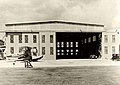
In June 1944, most of the base's supplies were relocated to the Pacific, where there was a greater demand for equipment. By 1946, the facility was designated as "caretaker status" and operations were handed over to airlines for civilian service. [7] The base was redesignated for the last time as MCAF St. Thomas, Virgin Islands on 8 August 1947, and decommissioned on February 16, 1948. [3] The airport was then leased to the US Department of the Interior for civilian use, with the Navy reserving the power to reactivate the airport for military purposes. After the transfer, the former hangar was converted into the civilian terminal and named after President Harry S. Truman. The airport operates as the Cyril E. King Airport, a civilian facility servicing St. Thomas. [2]

On 25 March 1950 the Department of the Interior leased the land to the US Virgin Islands. However, the department canceled the lease on 1 July 1954 citing violations of the agreement whereby the US Virgin Islands failed to register and report financial transactions relating to the land; the property was given to the US Virgin Islands Corporation. [8]

Commanding officers

Bourne Field commanding officers: [9]

StartEndNameImage
Pre-war24 June 1942 Lieutenant Colonel Ford Rodgers Ford O. Rogers.jpg
25 June 194220 June 1944Lieutenant Colonel Harold Major
21 June 19442 September 1945 Captain Rodgers Humphreys

Related Research Articles

<span class="mw-page-title-main">Moffett Federal Airfield</span> Joint civil-military airport in California

Moffett Federal Airfield, also known as Moffett Field, is a joint civil-military airport located in an unincorporated part of Santa Clara County, California, United States, between northern Mountain View and northern Sunnyvale. On November 10, 2014, NASA announced that it would be leasing 1,000 acres (400 ha) of the airfield property to Google for 60 years.

<span class="mw-page-title-main">Bauerfield International Airport</span> Airport in Port Vila, Vanuatu

Bauerfield International Airport is an airport located in Port Vila, Vanuatu. The airport is relatively small in size, but its runway has the capability and length to accept jets up to the Airbus A330. It serves as the hub for Vanuatu's flag carrier airline, Air Vanuatu.

<span class="mw-page-title-main">Marine Corps Air Station Yuma</span> US Marine Corps base in Yuma, Arizona, United States

Marine Corps Air Station Yuma or MCAS Yuma is a United States Marine Corps air station. It is the home of multiple squadrons of F-35B Lightning IIs of the 3rd Marine Aircraft Wing, Marine Aviation Weapons and Tactics Squadron 1 (MAWTS-1), Marine Operational Test and Evaluation Squadron 1 (VMX-1) and Marine Fighter Training Squadron 401 (VMFT-401), an air combat adversary squadron of the 4th Marine Aircraft Wing of the Marine Corps Reserve. It is a designated Superfund site due to a number of soil and groundwater contaminants, including asbestos.

<span class="mw-page-title-main">Naval Air Station Whidbey Island</span> U.S. Navy airbase in Washington state

Naval Air Station Whidbey Island (NASWI) is a naval air station of the United States Navy located on two pieces of land near Oak Harbor, on Whidbey Island, in Island County, Washington.

<span class="mw-page-title-main">Floyd Bennett Field</span> Historic former airport in Brooklyn, New York

Floyd Bennett Field is an airfield in the Marine Park neighborhood of southeast Brooklyn in New York City, along the shore of Jamaica Bay. The airport originally hosted commercial and general aviation traffic before being used as a naval air station. Floyd Bennett Field is currently part of the Gateway National Recreation Area's Jamaica Bay Unit, and is managed by the National Park Service (NPS). While no longer used as an operational commercial, military, or general aviation airfield, a section is still used as a helicopter base by the New York City Police Department (NYPD), and one runway is reserved for hobbyists flying radio-controlled aircraft.

<span class="mw-page-title-main">Naval Air Station Glenview</span>

Naval Air Station Glenview or NAS Glenview was an operational U.S. Naval Air Station from 1923 to 1995. Located in Glenview, Illinois, a suburb of Chicago, the air base primarily operated training aircraft as well as seaplanes on nearby Lake Michigan during World War II. Reconfigured as a Naval Air Reserve base following World War II, NAS Glenview supported Naval Air Reserve, Marine Air Reserve/4th Marine Aircraft Wing, and U.S. Army Reserve 244th Aviation Group as well as an active duty Coast Guard Air Station.

<span class="mw-page-title-main">Naval Air Station Jacksonville</span> United States Navy air base in Jacksonville, Florida, USA

Naval Air Station Jacksonville is a large naval air station located approximately eight miles (13 km) south of the central business district of Jacksonville, Florida, United States.

<span class="mw-page-title-main">Naval Air Station Alameda</span> Former US Naval Air Station in Alameda, California

Naval Air Station Alameda was a United States Navy Naval Air Station in Alameda, California, on San Francisco Bay.

<span class="mw-page-title-main">Cyril E. King Airport</span> Airport in Saint Thomas, U.S. Virgin Islands

Cyril E. King Airport is a public airport located two miles (3 km) west of the central business district of Charlotte Amalie on the island of St. Thomas in the United States Virgin Islands. It is currently the busiest airport in the United States Virgin Islands, and one of the busiest in the eastern Caribbean, servicing 1,403,000 passengers from July 2015 through June 2016. The airport also serves the island of St. John and is additionally often used by those travelling to the nearby British Virgin Islands.

Port Havannah is a port village on Efate Island in Vanuatu.

<span class="mw-page-title-main">Johnston Island Air Force Base</span> Airport in Johnston Atoll

Johnston Island Air Force Base is a former United States Air Force base on the Johnston Atoll in the United States Minor Outlying Islands, in the Pacific Ocean several hundred kilometers southwest of Hawaii. After its closure, it briefly operated as Johnston Atoll Airport, until that also closed in 2005.

<span class="mw-page-title-main">Stallings Air Base</span> Former United States Air Force base

Stallings Air Base was a United States Air Force base operational from 1944 to 1957. It later reopened as Kinston Airport and is now known as Kinston Regional Jetport.

<span class="mw-page-title-main">Marine Corps Air Station Kaneohe Bay</span> US Marine Corps base in Hawaii, United States

Marine Corps Air Station Kaneohe Bay or MCAS Kaneohe Bay is a United States Marine Corps (USMC) airfield located within the Marine Corps Base Hawaii complex, formerly known as Marine Corps Air Facility (MCAF) Kaneohe Bay or Naval Air Station (NAS) Kaneohe Bay. It is located two miles northeast of the central business district of Kaneohe, in Honolulu County, Hawaii, United States. The airfield has one runway (4/22) with a 7,771 x 200 ft asphalt surface.

<span class="mw-page-title-main">Naval Air Station Squantum</span> Naval aviation facility in Massachusetts

Naval Air Station Squantum was an active naval aviation facility during 1917 and from 1923 until 1953. The original civilian airfield that preceded it, the Harvard Aviation Field, dates back to 1910. The base was sited on Squantum Point in the city of Quincy, Massachusetts. It also abutted Dorchester Bay, Quincy Bay, and the Neponset River.

<span class="mw-page-title-main">Luganville Airfield</span>

Luganville Airfield or Bomber Field #3 is a former World War II airfield on the island of Espiritu Santo in the New Hebrides Islands at the Espiritu Santo Naval Base.

<span class="mw-page-title-main">Ulithi Airport</span> Airport in Yap State, Federated States of Micronesia

Ulithi Civil Airfield is a public airport serving the island of Falalop, located in the Ulithi Atoll in the Caroline Islands, Federated States of Micronesia. It was previously Falalop Airfield or Naval Air Base Ulithi, when used as a World War II airfield.

<span class="mw-page-title-main">US Naval Advance Bases</span> Overseas US Naval Bases

US Naval Advance Bases were built globally by the United States Navy during World War II to support and project U.S. naval operations worldwide. A few were built on Allied soil, but most were captured enemy facilities or completely new. Advance bases provided the fleet with support to keep ships tactically available with repair and supply depots of facilities, rather than return them to the continental United States. Before Japan declared war on the United States the U.S. Navy had a single fleet-sized advanced base in the Territory of Hawaii at Naval Station Pearl Harbor. During the war the U.S. Navy Seabees built over 400 advance bases categorized by size. Naval bases were either Lions or Cubs while airfields were either Oaks or Acorns. Lions and Oaks were major facilities while Cubs and Acorns were minor. PT Boats typically would get a Cub and airfields with single runways were Acorns. The larger bases could do refueling and overhaul; loading of troopship and cargo ships; and preparing amphibious assault ships. Some became major repair depots. The Seabees developed auxiliary floating drydocks were able to repair battle damage and do regular maintenance in the field saving ships trans-pacific trips for repair. A few bases also were developed to be R and R for all U.S. personnel. Most Advance Bases were built by the US Navy's Seabees in Naval Construction Battalions (CBs). At the start of the war civilian contractors were employed in construction. The Seabees in World War II built most of the airfields used by the United States Army Air Forces and United States Marine Corps, as they had the ships and cranes needed to transport the vast amount of equipment needed at the advance bases. The US Army and United States Coast Guard also operated out of many of these facilities. Seabees could build new or repair damaged runways, and with advancements in heavy bomber technology lengthen runways as needed. A few Naval Advance Bases were built for the Korean War and Vietnam War.

<span class="mw-page-title-main">San Clemente Naval Auxiliary Air Station</span> Military airport on San Clemente Island, California, United States

San Clemente Naval Auxiliary Air Station is a closed airfield located near the center of the San Clemente Island, California. Also called San Clemente Airfield, the airfield was built in 1934 with two 1,600-foot dirt runways. San Clemente Island is owned and operated by the United States Navy since November 7, 1934. The Works Progress Administration and a civilian contractor improved the airfield in 1938. The two runways were rebuilt to paved at 3,000-feet and 2,000 feet long by the WPA. The WPA also built a new hangar at the base. The airfield became a US Marines training base with the start of World War 2. A Marines squadron was station at Airfield and began air scouting training in 1942. The Marines trained in 19 Vought SB2U Vindicator carcraft and a one Grumman J2F Duck seaplane. The US Army installed two radar stations nearby and the runways were improved in 1941, the 3,000-foot runway was made into a 5,000-foot runway. In 1943 the airfield was renamed Naval Auxiliary Air Facility San Clemente Island. The Airfield supported bomb testing, radar training, Naval fighter gunnery training, and electronic countermeasures on the Island during the war. Over the years the size and scope of the airfield deduced, by 1977 the 2,000-foot runways was removed, and the east/west 5,000-foot runway was used rarely and closed at times. The deduced airfield was sometimes used for training in amphibious and air assault operational, also UAV operations. Today the runways as two helipads on the old runway. Naval Auxiliary Landing Field San Clemente Island became the main active Airfield.

<span class="mw-page-title-main">Naval Base Upolu</span> Naval base in United States

Naval Base Upolu was a naval base built by the United States Navy in 1942 to support the World War II effort. The base was located on Upolu Island, Samoa in the Western Pacific Ocean, part of the Samoan Islands's Naval Base Samoa. After the surprise attack on Naval Station Pearl Harbor on December 7, 1941, the US Navy was in need of setting up more advance bases in the Pacific Ocean. At Naval Base Upolu the Navy built a sea port, an airbase and a seaplane base.

<span class="mw-page-title-main">Naval Base Tarawa</span> Former Naval base of the United States

Naval Base Tarawa was a naval base built by the United States Navy in 1943 to support the World War II effort. The base was located on Tarawa atoll in the Gilbert Islands in the Central Pacific Ocean. The base was built as one of many advance bases in the island-hopping campaign towards the Empire of Japan. At Naval Base Tarawa the Navy built a seaport, seaplane base and two airbases. Construction started after the Battle of Tarawa ended November 23, 1943, part of Operation Galvanic.

References

  1. 1 2 "Article on Bourne Field (title unclear, through OCR)". Battle Creek Enquirer. 24 December 1940. p. 14 via Newspapers.com.
  2. 1 2 "Cyril E. King Airport - St. Thomas". Virgin Islands Port Authority. Retrieved 2022-07-31.
  3. 1 2 3 4 5 6 Rottman, Gordon L. (2002). U.S. Marine Corps World War II Order of Battle: Ground and Air Units in the Pacific War, 1939-1945. Greenwood Publishing Group. ISBN   978-0-313-31906-8.
  4. 1 2 3 4 5 Building the Navy's Bases in World War II: A History of the Bureau of Yards and Docks, 1940-1946, Volume 2. U.S. Navy Seabee Museum. 1947.
  5. Johnson, Edward C.; États-Unis (1977). Marine Corps Aviation: The Early Years, 1912-1940. History and Museums Division, Headquarters, U.S. Marine Corps. pp. 68–69.
  6. Naval Aviation News. Chief of Naval Operations and Naval Air Systems Command, Navy Department. 1948. p. 26.
  7. "[Article on disposal of Bourne Field]". Chicago Tribune. 6 March 1946. p. 10 via Newspapers.com.
  8. "Interior transfers Bourne Field, Subbase, to ViCorp". The Virgin Islands Daily News. 25 June 1954 via Google News.
  9. Sherrod, Robert Lee (1952). History of Marine Corps aviation in World War II. Washington, Combat Forces Press. p. 440.