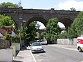
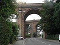
Bourne Valley Viaducts

Last updated
Bourne Valley Viaducts
Bourne Valley Viaducts (51277081441).jpg
The viaducts from the south in 2021
Coordinates 50°43′45″N1°54′48″W / 50.729305°N 1.913341°W / 50.729305; -1.913341
Characteristics
MaterialBrick
No. of spans10
Clearance below Gordon Road, Surrey Road
History
Built1888 (old bridge)
1893 (new bridge)
Closed1965 (original bridge)
Location
Bourne Valley Viaducts

The Bourne Valley Viaducts are two Victorian brick railway viaducts in Bournemouth and Poole, England. One bridge is disused while the other carries a section of the South West Main Line from London to Weymouth between Bournemouth railway station and Branksome railway station.

Contents

History

In 1888, London and South Western Railway constructed a viaduct consisting of ten curved arches. [1] In 1893, another viaduct was built on its west side that created a triangle of routes, allowing incoming trains to travel west towards Poole bypassing Bournemouth West railway station. [1] The railway bridge crosses the River Bourne. [1] Underneath the bridge are Surrey Road and Gordon Road near Coy Pond and Bournemouth Gardens as the railway follows Bourne Valley Road towards Branksome. [2] The original bridge was closed in 1965 during the Beeching cuts. [3] On 27 March 1941, an Luftwaffe air raid in World War II hit the nearby canteen at Bourne Valley Gasworks killing 33 people. [4] It is believed that the viaducts had been the intended target. [5] In 2020, a lorry crashed into the bridge. [6] The low arches at Bourne Valley Road reportedly make accidents common. [7] In 2023, improvements to the bridge were carried out by BCP Council. [8]

The military defences from World War II remain beneath the bridge.

Related Research Articles

<span class="mw-page-title-main">Bournemouth</span> Town in Dorset, England

Bournemouth is a coastal resort town on the south coast in the Bournemouth, Christchurch and Poole unitary authority area in the ceremonial county of Dorset, England. The town's urban subdivision had a population of 187,503 at the 2011 census making it the largest town in the county; the town is part of the South East Dorset conurbation, which has a population of 465,000.

<span class="mw-page-title-main">Poole</span> Town in England

Poole is a coastal town and seaport on the south coast of England in the Bournemouth, Christchurch and Poole unitary authority area in Dorset, England. The town is 21 miles (34 km) east of Dorchester and adjoins Bournemouth to the east. Since 1 April 2019, the local authority is Bournemouth, Christchurch and Poole Council. The town had an estimated population of 151,500 making it the second-largest town in the ceremonial county of Dorset. Together with Bournemouth and Christchurch, the conurbation has a total population of nearly 400,000.

<span class="mw-page-title-main">Ferndown</span> Human settlement in England

Ferndown is a town and civil parish in Dorset in southern England, immediately to the north of Bournemouth and Poole. The parish, which until 1972 was called Hampreston, includes the communities of Hampreston, Longham, Stapehill and Trickett's Cross. At the 2011 Census, the population of the parish was 26,559, making Ferndown the largest inland town in Dorset in terms of population, being larger than Dorchester.

<span class="mw-page-title-main">Sandbanks</span> Human settlement in England

Sandbanks is an affluent neighbourhood of Poole, Dorset, on the south coast of England, situated on a narrow spit of around 1 km2 or 0.39 sq mi extending into the mouth of Poole Harbour.

<span class="mw-page-title-main">Bournemouth West (UK Parliament constituency)</span> UK Parliament constituency in England since 1950

Bournemouth West is a parliamentary constituency in Dorset represented in the House of Commons of the UK Parliament since 2010 by Conor Burns, a Conservative.

<span class="mw-page-title-main">Bournemouth railway station</span> Railway station in Dorset, England

Bournemouth railway station is the main railway station serving the seaside town of Bournemouth, Dorset, England. It was previously known as Bournemouth East and then Bournemouth Central. It has long been treated as an obligatory stop on the South West Main Line from London Waterloo to Weymouth. It is 108 miles 2 chains (173.8 km) down the main line from Waterloo and is situated between Pokesdown and Branksome.

<span class="mw-page-title-main">Branksome railway station</span> Railway station in Dorset, England

Branksome railway station serves the Branksome and Branksome Park areas of Poole in Dorset, England. It is on the South West Main Line, 110 miles 51 chains (178.1 km) down the line from London Waterloo.

<span class="mw-page-title-main">Branksome, Dorset</span> Human settlement in England

Branksome is a suburb of Poole, in the Bournemouth, Christchurch and Poole district, in the ceremonial county of Dorset, England. The area consists of residential properties and also a number of commercial and industrial areas.

<span class="mw-page-title-main">Westbourne, Dorset</span> Human settlement in England

Westbourne is a residential and shopping area of Bournemouth, Dorset, England. It is located in between Branksome, Poole and the centre of Bournemouth, just off the A338. Poole Road, mainly full of specialised shops and small cafes, runs through the centre of Westbourne with Seamoor Road curving round bringing more shops and services. Many of the shops have residential property above them.

<span class="mw-page-title-main">A338 road</span> Road in southern England

The A338 is a major primary route in southern England, that runs from the junction with the A35 at Poole in Dorset to the junction with the A420 at Besselsleigh in Oxfordshire, a distance of 84 miles (135 km).

<span class="mw-page-title-main">River Bourne, Dorset</span> River in Dorset, England

The River Bourne is a small river in Dorset, England. It flows into the English Channel at Bournemouth, taking its name simply from Middle English bourn or burn, a small stream, and giving it to the town at its mouth.

<span class="mw-page-title-main">Grimstone Viaduct</span>

The Grimstone Viaduct is a railway bridge on the Castle Cary-Weymouth "Heart of Wessex" line in Dorset, England. It is directly north of the site of Grimstone and Frampton railway station, in the hamlet of Grimstone at the western edge of the parish of Stratton.

<span class="mw-page-title-main">Parkstone</span> Human settlement in England

Parkstone is an area of Poole, in the Bournemouth, Christchurch and Poole district, in the ceremonial county of Dorset, England. It is divided into 'Lower' and 'Upper' Parkstone. Upper Parkstone - "Up-on-'ill" as it used to be known in local parlance - is so-called because it is largely on higher ground slightly to the north of the lower-lying area of Lower Parkstone - "The Village" - which includes areas adjacent to Poole Harbour.

<span class="mw-page-title-main">History of Bournemouth</span> Coastal city in southern England

The history of Bournemouth and human settlement in the surrounding area goes back for thousands of years. Bournemouth is a coastal town on the island of Great Britain in Dorset, England, United Kingdom.

<span class="mw-page-title-main">Transport in Dorset</span>

Dorset is a county in South West England. The county is largely rural and therefore does not have a dense transport network, and is one of the few English counties without a motorway. Owing to its position on the English Channel coast, and its natural sheltered harbours, it has a maritime history, though lack of inland transport routes have led to the decline of its ports.

<span class="mw-page-title-main">Alder Hills</span>

Alder Hills is a suburb in Dorset that crosses the boundaries of Bournemouth and Poole. It is south of Wallisdown, east of Alderney and north of Parkstone.

<span class="mw-page-title-main">Bournemouth Town Hall</span> Municipal building in Bournemouth, Dorset, England

Bournemouth Town Hall, also known as the Civic Centre and formerly the Mont Dore Hotel, is a municipal facility in Bourne Road, Bournemouth, England. The town hall, which is the meeting place of Bournemouth, Christchurch and Poole Council, is a Grade II listed building. The town hall stands opposite Bournemouth Gardens and the Bournemouth War Memorial and is adjacent to St. Andrew's Church, Richmond Hill.

<span class="mw-page-title-main">Alderney and Bourne Valley (ward)</span>

Alderney and Bourne Valley is a ward in Poole, Dorset. Since 2019, the ward has elected 3 councillors to Bournemouth, Christchurch and Poole Council.

<span class="mw-page-title-main">Bournemouth Blitz</span> German bombing raids on Bournemouth, England during WWII

The Bournemouth Blitz was the heavy bombing of Bournemouth, Hampshire, England from 1940 to 1944, by the Nazi German Luftwaffe during the Second World War.

<span class="mw-page-title-main">Bournemouth Gardens, England</span> Garden in Dorset, England

Bournemouth Gardens are Grade II listed gardens in the town of Bournemouth, Dorset, England. Created in the nineteenth century, the gardens follow the towns eponymous River Bourne three kilometres from the historic boundary with Poole south-eastwards into Bournemouth Town Centre.

References

  1. 1 2 3 Baddeley, Nicole (25 May 2021). "Dorset's impressive railway viaducts". Dorset Echo.
  2. "Dorset walk - Branksome Park and Coy Pond". Great British Life. Retrieved 2024-05-10.
  3. "Picture of the Day: Bourne Valley viaducts under construction in the 19th century". Bournemouth Echo. 2021-10-11. Retrieved 2024-05-10.
  4. "33 killed at lunch: Poole's worst World War II bombing". Bournemouth Echo. 2018-03-28. Retrieved 2024-05-10.
  5. "'Someone screamed "Down! Down!"' – the Bourne Valley bombing | Dorset Life - The Dorset Magazine" . Retrieved 2024-05-10.
  6. "Lorry roof ripped off as it hits Poole railway bridge". BBC News. 2020-10-30. Retrieved 2024-05-10.
  7. "Lorry driver crashes into railway bridge". Dorset Echo. 2020-11-01. Retrieved 2024-05-10.
  8. "LISTED: The 55 roadworks in Bournemouth, Christchurch and Poole this week". Bournemouth Echo. 2023-04-17. Retrieved 2024-05-10.

See also