
Banff National Park is Canada's oldest national park, established in 1885. Located in Alberta's Rocky Mountains, 110–180 kilometres (68–112 mi) west of Calgary, Banff encompasses 6,641 square kilometres (2,564 sq mi) of mountainous terrain, with many glaciers and ice fields, dense coniferous forest, and alpine landscapes. The Icefields Parkway extends from Lake Louise, connecting to Jasper National Park in the north. Provincial forests and Yoho National Park are neighbours to the west, while Kootenay National Park is located to the south and Kananaskis Country to the southeast. The main commercial centre of the park is the town of Banff, in the Bow River valley.
Mount Forbes, the seventh tallest mountain in the Canadian Rockies and the tallest within the confines of Banff National Park, is located 18 km (11 mi) southwest of the Saskatchewan River Crossing in Banff Nat'l Park. The mountain was named by James Hector in 1859 after Edward Forbes, Hector's natural history professor at the University of Edinburgh during the mid-nineteenth century.
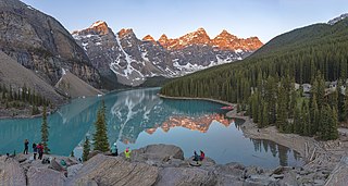
Moraine Lake is a glacially fed lake in Banff National Park, 14 kilometres (8.7 mi) outside the Village of Lake Louise, Alberta, Canada. It is situated in the Valley of the Ten Peaks, at an elevation of approximately 1,884 metres (6,181 ft). The lake has a surface area of 50 hectares.

Peyto Lake is a glacier-fed lake in Banff National Park in the Canadian Rockies. The lake itself is near the Icefields Parkway. It was named for Bill Peyto, an early trail guide and trapper in the Banff area.

Peyto Peak is a mountain in the Waputik Range, part of the Canadian Rockies in Alberta, Canada. It lies at the north end of the Wapta Icefield, in Banff National Park, about one km (0.6 mi) east of the border with British Columbia and 32 km (20 mi) north of the town of Field. Five kilometres to the northeast lies Bow Pass, one of the high points of the Icefields Parkway. Between the peak and the pass lies picturesque Peyto Lake. Three kilometres southwest of Peyto Peak is Mount Baker, the highest point in the immediate vicinity.
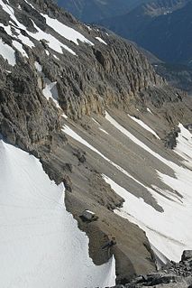
The Peyto Glacier is situated in the Canadian Rockies in Banff National Park, Alberta, Canada, approximately 90 km (56 mi) northwest of the town of Banff, and can be accessed from the Icefields Parkway. Peyto Glacier is an outflow glacier from the Wapta Icefield, which rests along the Continental divide. The glacier snout is subject to high melt rates from season to season and there is marked surface lowering on several parts of the glacier. Glacial silt, which is carried from the glacier by streams, ensures a turquoise appearance to Peyto Lake, a popular touring destination. As is true for the vast majority of glaciers worldwide, Peyto Glacier has been retreating rapidly, especially since the last half of the 20th century, and has reportedly lost 70% of its mass since it was first researched (Demuth and Keller, 2006). Between 1896 and 1966, the total volume loss of the Peyto Glacier was 1088.5 x 106 m3 (Wallace, 1995). In 1987, an automatic weather station was constructed near the glacier that monitors temperature changes, radiation and precipitation.
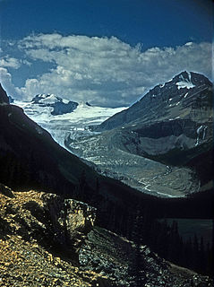
Bow Glacier is located in Banff National Park, Alberta, Canada, approximately 37 km (23 mi) northwest of Lake Louise. It can be viewed from the Icefields Parkway. Bow Glacier is an outflow glacier from the Wapta Icefield, which rests along the Continental Divide, and runoff from the glacier supplies water to Bow Lake and the Bow River. The glacier is credited for creating the Bow Valley before retreating at the end of the last glacial maximum.

The Waputik Icefield is located on the Continental divide in the Canadian Rocky Mountains, in the provinces of British Columbia and Alberta. It is developed on the heights of the Waputik Range in the Central Main Ranges.

The Wapta Icefield is located on the Continental Divide in the Waputik Mountains of the Canadian Rockies, in the provinces of British Columbia and Alberta. The icefield is shared by Banff and Yoho National Parks and numerous outlet glaciers extend from the icefield, including the Vulture, Bow and Peyto Glaciers. Runoff from the icefields and outlet glaciers supply water to both the Kicking Horse and Bow Rivers, as well as numerous streams and lakes.
The Stanley Mitchell hut is an alpine hut located at an altitude of 2,060 metres (6,759 ft) in the Little Yoho Valley in Yoho National Park, British Columbia. It sits in a small meadow not far from the base of a mountain called The President. It serves as a base for hiking, scrambling, ski-touring and climbing the nearby mountains. The hut is maintained by the Alpine Club of Canada.
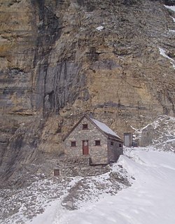
The Abbot Pass hut is an alpine hut located at an altitude of 2925 metres in Abbot Pass in the Rocky Mountains in Alberta, Canada. It is nestled between Mount Victoria and Mount Lefroy, straddling the continental divide, which, in this region, defines the boundary between Banff National Park in Alberta and Yoho National Park in British Columbia. While close to the border, the hut lies entirely in Banff National Park, and is the second-highest permanently habitable structure in Canada. The hut is maintained by the Alpine Club of Canada.
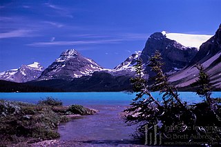
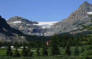
Bow Lake is a small lake in western Alberta, Canada. It is located on the Bow River, in the Canadian Rockies, at an altitude of 1920 m.

The Fay hut was an alpine hut located above Prospectors Valley in Kootenay National Park, British Columbia. Although the higher Neil Colgan hut superseded it as a base for climbs in the Valley of the Ten Peaks area, it still served as a convenient base for hikers and skiers doing day trips in the area, and as an overnight stop for mountaineers continuing on to the Neil Colgan hut. A new hut was built in 2005 to replace the original Fay hut, which was destroyed by a forest fire in 2003. The Fay hut was maintained by the Alpine Club of Canada (ACC).

Alberta's Rockies comprises the Canadian Rocky Mountains in Alberta, Canada. It is a region on the southwestern part of the province, along the British Columbia border. It covers all but the south of Census Division 15.

The R.J. Ritchie Hut is an alpine hut located at an altitude of 2,470 metres (8,100 ft) between the southern tip of the Wapta Icefield and the northern tip of the Waputik Icefield in Banff National Park. The hut is at the half-way mark for the Wapta traverse and is usually used in conjunction with the other huts in this chain while attempting a cross-glacier ski trip. The hut is maintained by the Alpine Club of Canada.
The Neil Colgan Hut is an alpine hut on the Fay Glacier in Kootenay National Park in British Columbia, Canada. It is in a col between Mount Little and Mount Bowlen, one of the peaks overlooking the Valley of the Ten Peaks. The hut is maintained by the Alpine Club of Canada and is the highest permanent structure in Canada. It is named for hiker and adventurer Neil M. Colgan.
The Peter and Catharine Whyte Hut, also known as the Peyto Hut, is an alpine hut located on the northern tip of the Wapta Icefield in Banff National Park. It is nicknamed the Peyto hut due to its proximity on the Peyto Glacier. The hut is maintained by the Alpine Club of Canada.

Mount Thompson is a 3,089-metre (10,135-foot) mountain summit located four kilometers west of Bow Lake in Banff National Park, in the Canadian Rockies of Alberta, Canada. Its nearest higher peak is Mount Baker, 5.0 km (3.1 mi) to the west. Mount Thompson is situated east of the Wapta Icefield, and is a member of the Waputik Mountains. Mount Thompson can be seen from the Icefields Parkway at Bow Lake.

Mount Jimmy Simpson is a 2,966-metre (9,731-foot) summit located 3 kilometres northwest of Bow Lake in Banff National Park, in the Canadian Rockies of Alberta, Canada. Its nearest higher peak is Mount Thompson, 3.0 km (1.9 mi) to the southwest. Mount Jimmy Simpson is a member of the Waputik Mountains, and is situated east of the Wapta Icefield and west of the Bow River valley. Mount Jimmy Simpson can be seen from the Icefields Parkway at Bow Lake. Jimmy Simpson Junior is a 2,721 meter sub-summit east of the mountain.

Portal Peak is a 2,926-metre (9,600-foot) mountain summit located four kilometers west of Bow Lake in Banff National Park, in the Canadian Rockies of Alberta, Canada. Its nearest higher peak is Mount Thompson, 1.0 km (0.62 mi) to the northwest. Portal Peak is situated east of the Wapta Icefield, and is a member of the Waputik Mountains. Portal Peak can be seen from the Icefields Parkway at Bow Lake.

