Related Research Articles
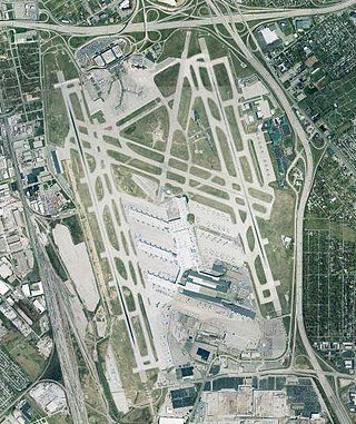
Louisville Muhammad Ali International Airport, formerly known as simply Louisville International Airport, is a civil-military airport in Louisville in Jefferson County, Kentucky. The airport covers 1,500 acres (6.1 km2) and has three runways. Its IATA airport code, SDF, is based on the airport's former name, Standiford Field. It has no regularly-scheduled international passenger flights, but it is a port of entry, as it handles numerous international cargo flights through the United Parcel Service's worldwide air hub through its airline, often referred to as UPS Worldport.

Augusta State Airport is a public use airport located one nautical mile (2 km) west of the central business district of the state capital of Augusta, a city in Kennebec County, Maine, United States. The airport is owned by the state of Maine, but managed and operated by the city of Augusta. It is served by one commercial airline, with scheduled passenger service subsidized by the Essential Air Service program.

Presque Isle International Airport, formally Northern Maine Regional Airport at Presque Isle, is a mile northwest of Presque Isle, in Aroostook County, Maine, United States. It serves the residents of Presque Isle and a vast area of northern Maine and northwestern New Brunswick. Airline flights to Newark Liberty International Airport are subsidized by the federal government's Essential Air Service program at a cost of $3,892,174.
Hancock County–Bar Harbor Airport is a county-owned, public-use airport located in Trenton, Maine, eight nautical miles northwest of the central business district of Bar Harbor, a city in Hancock County, Maine, United States. It serves the residents of Hancock County with commercial and charter aviation services. During the summer months, the airport becomes one of Maine's busiest, with significant private jet operations bringing visitors to the numerous summer colonies in the county, which includes Mount Desert Island. Scheduled passenger airline service is subsidized by the Essential Air Service program.

Bowman Field is a public airport five miles (8.0 km) southeast of downtown Louisville, in Jefferson County, Kentucky. The airport covers 426 acres (172 ha) and has two runways. The FAA calls it a reliever airport for nearby Louisville Muhammad Ali International Airport.

Nome Airport is a state-owned public-use airport located two nautical miles (4 km) west of the central business district of Nome, a city in the Nome Census Area of the U.S. state of Alaska.

Madras Municipal Airport, formerly City-County Airport, is a public use airport located three nautical miles (6 km) northwest of the central business district of Madras, a city in Jefferson County, Oregon, United States. According to the FAA's National Plan of Integrated Airport Systems for 2009–2013, it is classified as a general aviation airport.
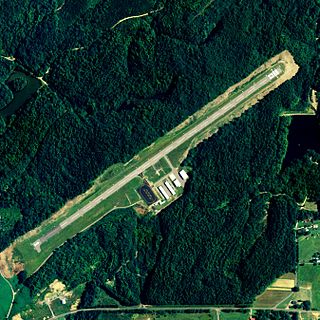
Bowman Field is a public airport located three miles (5 km) northeast of the central business district of Anaconda, a city in Deer Lodge County, Montana, United States. It is owned by Anaconda City and Deer Lodge County.

Posey Field is a city-owned public-use airport located three nautical miles northeast of the central business district of Haleyville, a city in Winston County, Alabama, United States.
Robbins Field is a public use airport located five nautical miles northeast of the central business district of Oneonta, a city in Blount County, Alabama, United States. It is owned by the City of Oneonta and Blount County. According to the FAA's National Plan of Integrated Airport Systems for 2009–2013, it is categorized as a general aviation facility.
Old Town Municipal Airport and Seaplane Base, also known as Dewitt Field, is a public use airport located two nautical miles (4 km) northwest of the central business district of Old Town, in Penobscot County, Maine, United States. It is owned by the City of Old Town. The seaplane base is located on Marsh Island on the Penobscot River.
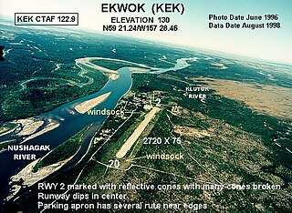
Ekwok Airport is a state-owned public-use airport serving Ekwok, a city in the Dillingham Census Area of the U.S. state of Alaska. Scheduled airline service to Merrill Field in Anchorage, AK is provided by Dena'ina air.

Bentonville Municipal Airport is a city-owned, public-use airport located two nautical miles (3.7 km) south of the central business district of Bentonville, a city in Benton County, Arkansas, United States. It is also known as Louise M. Thaden Field or Louise Thaden Field, a name it was given in 1951 to honor Louise McPhetridge Thaden (1905–1979), an aviation pioneer from Bentonville.

Deblois Flight Strip is a public-use airport located two nautical miles southeast of the central business district of Deblois, a town in Washington County, Maine, United States. It is currently owned by the Maine Department of Transportation, and managed by Randy Gray, Superintendent of Operations for the Eastern Region.
Islesboro Airport is a town owned public use airport located one nautical mile west of the central business district of Islesboro, a town in Waldo County, Maine, United States. This airport is included in the FAA's National Plan of Integrated Airport Systems for 2009–2013, which categorized it as a general aviation facility.
Long Lake Seaplane Base is a privately owned, public use seaplane base on Long Lake in Aroostook County, Maine, United States. It is located at the Long Lake Sporting Club, three nautical miles (6 km) northeast of the central business district of Sinclair, Maine.
Newton Field is a town-owned, public use airport located one nautical mile (2 km) west of the central business district of Jackman, a town in Somerset County, Maine, United States. It is included in the National Plan of Integrated Airport Systems for 2011–2015, which categorized it as a general aviation facility.
James G. Whiting Memorial Field is a city-owned public-use airport located one nautical mile (2 km) north of the central business district of Mapleton, a city in Monona County, Iowa, United States. It is included in the National Plan of Integrated Airport Systems for 2011–2015, which categorized it as a general aviation facility.
Pittsfield Municipal Airport is a town owned, public use airport located one nautical mile (2 km) southeast of the central business district of Pittsfield, a town in Somerset County, Maine, United States. It is included in the National Plan of Integrated Airport Systems for 2011–2015, which categorized it as a general aviation facility.
Gillespie Field is a public use airport located one nautical mile (2 km) west of the central business district of Meddybemps, a town in Washington County, Maine, United States.