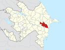
Astara District is one of the 66 districts of Azerbaijan. It is located in the southeast of the country, in the Lankaran-Astara Economic Region. The district borders the districts of Lankaran and Lerik, as well as the Ardabil and Gilan provinces of Iran. Its capital and largest city is Astara. As of 2020, the district had a population of 110,000.

Jabrayil District is one of the 66 districts of Azerbaijan. It is located in the south-west of the country and belongs to the East Zangezur Economic Region. The district borders the districts of Khojavend, Fuzuli, Qubadli, Zangilan, and the Islamic Republic of Iran.

Goranboy District is one of the 66 districts of Azerbaijan. It is located in the west of the country in the Ganja-Dashkasan Economic Region. The district borders the districts of Kalbajar, Tartar, Yevlakh, Samukh, and Goygol. Its capital and largest city is Goranboy. As of 2020, the district had a population of 105,000.

Zangilan District is one of the 66 districts of Azerbaijan. It is located in the south-west of the country and belongs to the East Zangezur Economic Region. The district borders the districts of Qubadli, Jabrayil, the Syunik Province of Armenia and the East Azerbaijan Province of Iran. Its capital and largest city is Zangilan. As of 2020, the district had a nominal population of 45,200.

Khojavend District is one of the 66 districts of Azerbaijan. It is located in the west of the country in the Karabakh Economic Region. The district borders the districts of Lachin, Shusha, Khojaly, Aghdam, Aghjabadi, Fuzuli, Jabrayil, and Qubadli. Its capital and largest city is Khojavend. As of 2020, the district had a nominal population of 44,100.

Qubadli is a city in Azerbaijan and the administrative centre of the Qubadli District. It is situated along the Vorotan (Bargushad) river.
Karabakh is a geographic region in southwestern Azerbaijan and eastern Armenia, extending from the highlands of the Lesser Caucasus down to the lowlands between the rivers Kura and Aras. It is divided into three regions: Highland Karabakh, Lowland Karabakh, and the eastern slopes of the Zangezur Mountains.
Gülablı, also known as Abdal-Gülablı, is a village in the Aghdam District of Azerbaijan.
Syrkhavend or Nor Ghazanchi is a village located in the Agdam District of Azerbaijan, in the disputed region of Nagorno-Karabakh. The village had an Azerbaijani majority prior to their expulsion during the First Nagorno-Karabakh War.
Çullu is a village situated on Goyan steppe, 27 km west of the city of Jabrayil, within the Dagh Tumas administrative-territorial unit of Jabrayil District, Azerbaijan.
Dagh Tumas is a village in the administrative unit with the same name of Jabrayil District of Azerbaijan, located on the southwestern slopes of Karabakh ridge, 23 km to the west of Jabrayil city.

Charektar is a village in the Kalbajar District of Azerbaijan, in the region of Nagorno-Karabakh. The village had an Azerbaijani-majority population prior to their exodus during the First Nagorno-Karabakh War. Before 2023, it was controlled by the breakaway Republic of Artsakh as part of its claimed Shahumyan Province.
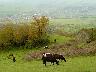
Günəşli, is a village and municipality in the Lerik District of Azerbaijan. It has a population of 1,022. The municipality consists of the villages of Guneshli and Babagil.
Sirik is a village in the administrative unit of the same name, Jabrayil district, Azerbaijan, located on the slopes of the Karabakh ridge, 15 km northwest of the city of Jabrayil.
Daşbulaq is a ghost village in the Kalbajar District of Azerbaijan.

Zandabad is a village in Owch Hacha Rural District of the Central District of Ahar County, East Azerbaijan province, Iran.
Nakhchivan, also transliterated as Nakhichevan may refer to:
Astanjin is a village in Kaghazkonan-e Markazi Rural District of Kaghazkonan District, Mianeh County, East Azerbaijan province, Iran.
Mavana is a village in, and the capital of, Targavar Rural District of Silvaneh District of Urmia County, West Azerbaijan province, Iran.
Hovarsin is a village in, and the former capital of, Sumay-ye Jonubi Rural District of Sumay-ye Beradust District of Urmia County, West Azerbaijan province, Iran. The capital of the rural district has been transferred to the village of Hashtian.