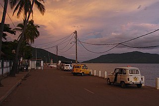
Andoany, formerly and more commonly known as Hell-Ville, is a city in Diana Region, Madagascar with a population estimated at 39,500 in 2013. It lies on the island of Nosy Be, of which it is the capital. It is located at 13°24′0″S48°16′0″E.

Wulingyuan is a scenic and historical site in the Wulingyuan District of south-central China's Hunan Province. It was inscribed as a UNESCO World Heritage Site in 1992. It is noted for more than 3,000 quartzite sandstone pillars and peaks across most of the site, many over 200 metres (660 ft) in height, along with many ravines and gorges with attractive streams, pools, lakes, rivers and waterfalls. It features 40 caves, many with large calcite deposits, and a natural bridge named Tianqiashengkong, which is one of the highest natural bridges in the world.

Pelalawan is a regency (kabupaten) of Riau, Indonesia. It is located on the island of Sumatra. The regency has an area of 758.45 km² and population of 301,829 at the 2010 Cenmsus; the latest official estimate was 346,532. The administrative centre is at Pangkalan Kerinci.

Tuscarora Mountain is a mountain ridge of the Appalachian Mountains in the Ridge and Valley province in central Pennsylvania. It reaches its highest point on Big Mountain (Pennsylvania) at 2,458 feet (749 m) above sea level. The mountain is named after the Tuscarora people.
The Lytton First Nation, a First Nations government, has its headquarters at Lytton in the Fraser Canyon region of the Canadian province of British Columbia. While it is the largest of all Nlaka'pamux bands, unlike all other governments of the Nlaka'pamux (Thompson) people, it is not a member of any of the three Nlaka'pamux tribal councils, which are the Nicola Tribal Association, the Fraser Canyon Indian Administration and the Nlaka'pamux Nation Tribal Council.
Perarrúa, in Ribagorçan and Aragonese: Perarruga is a municipality located in the province of Huesca, Aragon, Spain. According to the 2004 census (INE), the municipality has a population of 123 inhabitants.

Djezzar, Algeria is a town in north-eastern Algeria.
Harry's Brook was a small place located north east of Stephenville Crossing.

Getik is a small village in the Gegharkunik Province of Armenia. It was founded in 1922 by settlers from Hin Bashkend, and has megalithic monuments, khachkars and an Iron Age cyclopean fort by the name of "Mughani Khach".

Nor Gyugh is a town in the Kotayk Province of Armenia. 'Nor Gyugh' translates as 'New Village' in English.

Tsiatsan is a village in the Armavir Province of Armenia.

Voskehask is a village in the Shirak Province of Armenia.

Motułka is a village in the administrative district of Gmina Sztabin, within Augustów County, Podlaskie Voivodeship, in north-eastern Poland. It lies approximately 10 kilometres (6 mi) north-west of Sztabin, 13 km (8 mi) south of Augustów, and 70 km (43 mi) north of the regional capital Białystok.

Julianów is a village in the administrative district of Gmina Tarłów, within Opatów County, Świętokrzyskie Voivodeship, in south-central Poland. It lies approximately 5 kilometres (3 mi) south of Tarłów, 29 km (18 mi) north-east of Opatów, and 80 km (50 mi) east of the regional capital Kielce.

Kozietuły Nowe is a village in the administrative district of Gmina Mogielnica, within Grójec County, Masovian Voivodeship, in east-central Poland. It lies approximately 7 kilometres (4 mi) north-east of Mogielnica, 16 km (10 mi) south-west of Grójec, and 56 km (35 mi) south of Warsaw.

Bukowy Las is a village in the administrative district of Gmina Dominowo, within Środa Wielkopolska County, Greater Poland Voivodeship, in west-central Poland. It lies approximately 10 kilometres (6 mi) east of Dominowo, 14 km (9 mi) east of Środa Wielkopolska, and 42 km (26 mi) east of the regional capital Poznań.
Wielimowo is a village in the administrative district of Gmina Miłomłyn, within Ostróda County, Warmian-Masurian Voivodeship, in northern Poland.

Sitno is a settlement in the administrative district of Gmina Barlinek, within Myślibórz County, West Pomeranian Voivodeship, in north-western Poland. It lies approximately 12 kilometres (7 mi) south-east of Barlinek, 28 km (17 mi) east of Myślibórz, and 73 km (45 mi) south-east of the regional capital Szczecin.
The Chain Islets and Great Chain Island are a group of at least 18 islets situated off the east coast of Oak Bay, British Columbia, Canada. They lie in Mayor Channel about halfway between Mary Tod Island (W) and Discovery Island (E). Most of the islets are very small, rocky, and are unnamed, except for Great Chain Island which is covered in grass and herbaceous cover with occasional shrub thickets. The islets are noted as an important gathering place for harbor seals in the summer and for many seabirds such as seagulls and cormorants.
Altlichtenberg is a populated place in Upper Austria, Austria.


