Brackenhills railway station

Last updated

Brackenhills
Brackenhills railway station platform remnants.JPG
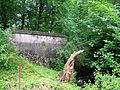
Remains of the station platform in 2010
General information
LocationNear Beith, Ayrshire
Scotland
Coordinates 55°43′57″N4°39′01″W / 55.7325°N 4.6502°W / 55.7325; -4.6502 Coordinates: 55°43′57″N4°39′01″W / 55.7325°N 4.6502°W / 55.7325; -4.6502
Grid reference NS336519
Platforms1
Other information
StatusDisused
History
Original company Lanarkshire and Ayrshire Railway
Pre-grouping Caledonian Railway
Post-grouping LMS
Key dates
1 September 1906Opened [1]
1 December 1930Closed [1]

Brackenhills railway station was a railway station approximately one mile south-west of the town of Beith, close to Barkip, North Ayrshire, Scotland, part of the Lanarkshire and Ayrshire Railway.

Contents

History

The station opened on 1 September 1906 on the branch to Kilbirnie. [1] The station closed on 1 December 1930. [1]

Today the station platform still exists though it is overgrown and in very poor condition. The stationmaster's house is now a private residence.

The 1858 Ordnance Survey (OS) shows a 'weighing machine' at what was eventually to become Brackenhills railway station, related to the Hillhead Railway to Broadstone limestone quarry, the exchange and offloading bay for which were nearby. Many other ironstone and limestone also quarries existed in the immediate area. The 1897 OS map shows a 'Brackenhills Siding' at the site and the station is shown on the 1920s map.

Services

A shuttle service ran via this station on the way to Giffen from Kilbirnie and back, with around nine return journeys per day during the week and an extra two on Saturdays. [2] In 1912 the local paper reported that 16 trains per day ran to Ardrossan and Glasgow Central station from Brackenhills. [3]

Freight

The LMS appendix records [4] that

Brackenhills Station siding. - This siding may be worked by trains proceeding from Giffen towards Kilbirnie (South), and during shunting operations the points must be set for the siding and remain in that position until the work is completed.
This siding may also be worked by trains not exceeding 12 wagons and brake van coming from Glengarnock (High) and proceeding towards Giffen. In such cases the train must be taken inside the sidings, and no vehicle is to be left on the main branch line. The station master at Brackenhills must inform the signalman at Glengarnock (High) by telegraph when there is traffic to lift and the train must be signalled in accordance with Train Tablet Regulation 8.

Preceding station Historical railways Following station
Glengarnock
Line and station closed
  Caledonian Railway
Lanarkshire and Ayrshire Railway
  Giffen
Line and station closed

Related Research Articles

Neilston railway station Railway station in East Renfrewshire, Scotland, UK

Neilston railway station is a railway station in the village of Neilston, East Renfrewshire, Greater Glasgow, Scotland. The station is managed by ScotRail and lies on the Cathcart Circle Lines, 11+34 miles (18.9 km) southwest of Glasgow Central.

Glengarnock railway station Railway station in North Ayrshire, Scotland

Glengarnock railway station is a railway station in the village of Glengarnock, North Ayrshire, Scotland, serving the towns of Beith and Kilbirnie. The station is managed by ScotRail and is on the Ayrshire Coast Line.

The Lanarkshire and Ayrshire Railway (L&AR) was an independent railway company built to provide the Caledonian Railway with a shorter route for mineral traffic from the coalfields of Lanarkshire to Ardrossan Harbour, in Scotland.

Giffen railway station

Giffen railway station was a railway station approximately one mile south-west of the village of Barrmill, North Ayrshire, Scotland. The station was part of the Lanarkshire and Ayrshire Railway.

Auchenmade railway station Disused railway station in Ayrshire, Scotland

Auchenmade railway station was a railway station approximately three miles north-east of Kilwinning on the B707, North Ayrshire, Scotland. It served the hamlet of Auchentiber and the surrounding rural area as part of the Lanarkshire and Ayrshire Railway. The station was 6.75 miles from the Lugton East Junction.

The Dalry and North Johnstone Line was a branch of the Glasgow and South Western Railway (G&SWR) in Renfrewshire and Ayrshire, Scotland, connecting the stations in Elderslie and Dalry via a route running parallel to the existing line built by the Glasgow, Paisley, Kilmarnock and Ayr Railway. This provided additional line capacity for Ayrshire Coast and Kilmarnock services. The loop line was used for passenger services until the mid-1960s, when it was closed by the Beeching Axe. The majority of the line's trackbed has since been absorbed into the Sustrans National Cycle Network.

Glengarnock High railway station was a railway station serving the village of Glengarnock, North Ayrshire, Scotland as part of the Lanarkshire and Ayrshire Railway.

Kilbirnie South railway station was a railway station serving the town of Kilbirnie, North Ayrshire, Scotland as part of the Lanarkshire and Ayrshire Railway (L&AR).

Uplawmoor (L&A) railway station Railway station in East Renfrewshire, Scotland, UK

Uplawmoor railway station was a railway station serving the village of Uplawmoor, East Renfrewshire, Scotland as part of the Lanarkshire and Ayrshire Railway.

Cunninghamhead railway station

Cunninghamhead railway station (NS369414) was a railway station serving Cunninghamhead Estate, the village of Crossroads, North Ayrshire and the town of Stewarton, East Ayrshire, Scotland. The station was originally part of the Glasgow, Paisley, Kilmarnock and Ayr Railway.

Beith North railway station Railway station serving the north of the town of Beith, North Ayrshire, Scotland

Beith North railway station was a railway station serving the north of the town of Beith, North Ayrshire, Scotland. The station was originally part of the Glasgow, Paisley, Kilmarnock and Ayr Railway.

Gateside, North Ayrshire Human settlement in Scotland

Gateside is a small village in North Ayrshire, Scotland about 12 mile east of Beith on the B777.

Barrmill, North Ayrshire Small village in North Ayrshire, Scotland

Barrmill is a small village in North Ayrshire, Scotland about 1+12 miles east of Beith on the road to Burnhouse and Lugton. Locally it is known as the Barr.

Broadstone Castle Castle in Ayrshire, Scotland

Broadstone lies close to the small village of Gateside in North Ayrshire, Scotland about half a mile east of Beith in the old Barony of Giffen.

Barkip Human settlement in Scotland

Barkip, also known as The Den, is a hamlet in North Ayrshire, Scotland about three miles southwest of Beith on the A737 road to Dalry. The earliest recorded name is 'Blairkip'. In the Gaelic language, the name Barkip comes from bar ("top"), and kip. It is not clear when or why the name 'The Den' started to be used although it appears in the local press as both in 1898, however in Scots as in old English one meaning is 'A hollow between hills,' which is certainly an accurate description of the geography of the area that Barkip lies in. Following construction of a new road, Barkip no longer sits on the main Beith to Dalry road.

Drumclog railway station

Drumclog was a railway station on the Darvel and Strathaven Railway serving a rural area that included the village of Drumclog in South Lanarkshire, Scotland.

Ryeland railway station

Ryeland was a railway station on the Darvel and Strathaven Railway serving a rural area in South Lanarkshire, Scotland.

Nethercleugh railway station was a station which served the rural area around Nethercleugh and the estate of Jardine Hall, 3 miles north of Lockerbie in Applegarth parish, Scottish county of Dumfries and Galloway. It was served by local trains on what is now known as the West Coast Main Line. The nearest station for Nethercleugh is now at Lockerbie.

Lissens Goods station

Lissens Goods station or Lissens Sidings station was a railway freight facility located approximately two miles north-east of Kilwinning, North Ayrshire, Scotland. It served the industrial and agricultural requirements for transportation in the vicinity of Auchenmade and the surrounding rural area on behalf of the Lanarkshire and Ayrshire Railway. Lissens Goods was around seven miles from the Lugton East Junction and the railway workers employed here were supervised by staff from the nearby Auchenmade Station, the nearest passenger and goods station on the up line towards Lugton and Glasgow.

Gree Goods station

Gree Goods station or Gree Depot as it was listed in the Caledonian Railway Working Timetable was a relatively short lived railway freight facility located approximately one miles south of Lugton on the A736 Lochlibo Road, North Ayrshire, Scotland. Gree Goods served the industrial and agricultural requirements for transportation in the vicinity, with the village of Burnhouse not far away, sitting on the crossroads to Barrmill, Dunlop and Irvine. Over Gree, High Gree, Nether Gree, Gree and Brownhills Farms were located nearby. Gree Goods was close to the Lugton East Junction, just south of the 11 arch Gree Viaduct. The nearest passenger station on the line north was Lugton High and to the south was Giffen.

References

Notes
  1. 1 2 3 4 Butt, page 41
  2. Stansfield, p. 28
  3. Reid, Donald L. & Monahan, Isobel F. (1999). Yesterday's Beith. A Pictorial Guide. Beith : Duke of Edinburgh Award. ISBN   0-9522720-5-9. P. 84
  4. LMS Appendix[ full citation needed ]
Sources