Barkip

Last updated

Barkip
  • The Den
Barkip or The den.JPG
A view of The Den
North Ayrshire UK location map.svg
Red pog.svg
Barkip
Location within North Ayrshire
OS grid reference NS 32640 51244
Council area
Lieutenancy area
Country Scotland
Sovereign state United Kingdom
Dialling code 01505
Police Scotland
Fire Scottish
Ambulance Scottish
UK Parliament
Scottish Parliament
List of places
UK
Scotland
55°43′32″N4°39′59″W / 55.725614°N 4.666426°W / 55.725614; -4.666426

Barkip, [1] also known as The Den, is a hamlet in North Ayrshire, Scotland about three miles (five kilometres) southwest of Beith on the A737 road to Dalry. The earliest recorded name is 'Blairkip'. [2] In the Gaelic language, the name Barkip comes from bar ("top"), and kip ("a rank of soldiers"). [3] It is not clear when or why the name 'The Den' started to be used although it appears in the local press as both in 1898, [4] however in Scots as in old English [5] one meaning is 'A hollow between hills,' which is certainly an accurate description of the geography of the area that Barkip lies in. [6] Following construction of a new road, Barkip no longer sits on the main Beith to Dalry road.

Contents

History

Pont's survey of the early 1600s records a 'Bar-Kyipe' lying in the Barony of Kersland and Dobie records that Barkip formed part of the estate of Roughwood in 1874, belonging to William Ralston-Patrick. [7] In the 19th century the population was 995. [8]

Willem Blaeu's map of circa 1604 records a 'Barkirsh' settlement, probably today's nearby 'Barcosh'. [9] William Roy's map of 1747 records the settlements of Mallside and a Blairkip. [2] In the year 1726, William Park and John his son granted to John Hamilton an heritable bond, in common form, for 3000 merks, over the lands of Barkip. [10] Barkip was part of the Blair Estate. [11]

In March 1898, a local paper reported a complaint that a dance had taken place at the Kersland Barony school and Kirk that had lasted into the small hours. Members of the church congregation threatened to leave through their indignation at the building being used for such frivolous activities. [4] That same month, students at the Kersland Barony evening continuation classes presented their teachers, Mr Deans and Miss Lorraine, with gifts of appreciation. The Rev A Leslie chaired the event and Miss Lorraine was presented with an inscribed umbrella, whilst Mr Deans had a silver walking stick as his recognition. Songs, recitations, flute, and violin entertainments were part of the night's proceedings. [4]

An 1876 publication, Catalogue of the western Scottish fossils, documented finds in Barkip's coal and ironstone pits and sandstone quarries, including that of Rhizodus , Gyracanthus , and Cladodus . [12] The village had a certain reputation for problems linked to illicit drinking. [1] [4] It was reported in 1898 that Sunday drinking resulted in men lying around drunk in the Maulside plantations and some were playing cards. [4] Jame Walker is recorded as being born on 4 September 1795 and lived at 20 Fore Row, 23 Barkip, The Den.

Geography

Geologically, Barkip consists of mainly sandstone. [13] Two areas of the rare habitat type known as 'raised bogs' are located at Barkip and Little Barkip. These were surveyed for the Ayrshire Biodiversity Action Plan (ABAP) by the NAC Ranger Service in 2010. Raised bogs develop over centuries from open lake, to marsh, and eventually bog that continues to form peat, and over time a shallow dome of bog peat develops: a raised bog. The dome is typically a few metres high in the centre, and is often surrounded by strips of fen. The Barkip sites have the typical bog plants, such as sundew, cotton grass, deer grass, and sphagnum mosses. Highfield is the next village along on the A737 towards Dalry.

Notable landmarks

The old Kersland Barony school had a church-like belfry over the front gale and was used as church on Sundays. [1] [14] [15] The Rev. Robert Stevenson D.D., minister of Dalry 1844–1890, caused to be erected the Kersland Barony Chapel and school. He bequeathed £2,500 for Kersland Barony chapel. [16] In 1901 the Herald recorded that "The scholars of Kersland Barony School, Dalry, under the direction of Mr Deans, headmaster, and Mr Gibson, drill instructor, gave a most enjoyable entertainment on two evenings last week". [17] The village at one time had a police station, two public houses, a cinema, and a bowling green. [18] Brackenhills railway station was located midway between Beith and Barkip on the Lanarkshire and Ayrshire Railway's branch to Kilbirnie South. Defence Munitions Beith (DM Beith) is located nearby. The hamlet contains several cottages including Auchengree Cottage, Rosehill Cottage and Muirhouse Cottage. A smithy was located at the Crossroads near where Graze Restaurant once stood. A second smithy was situated on the crossroads near West Muirhouse Farm and Highden House. This smithy, now demolished, was unusual in that it had stables associated with it; these survive as a private dwelling. An explosives magazine was located at the site of the old Low Well [19] opposite West Muirhouse Farm. Davidshill House was once an isolation hospital, locally known as the 'Sick House'.

Maulside House, previously Maulhead, [20] was built on the site of an earlier mansion held by the Russells. The present house was built for Andrew Mitchell, Writer to the signet, in the 1830s. he improved his estate lands, draining the mosses, turning them into productive fields. [21] Maulside Mains is a 'B' Listed, early 19th century, rectangular-plan stable block with a U-shaped courtyard beyond. [22] William Ronald, farmer at Mauleside, had been a gauds boy to Burns at Lochlea Farm, helping him with the ploughing by encouraging and guiding the team of horses whilst carrying a plough staff to clean the ploughshare when it clogged with earth. [23]

The Barkip Biogas Plant. Barkip Anaerobic-Digester Biomass powerplant.JPG
The Barkip Biogas Plant.

Located a short distance from the settlement is the Barkip Biogas power plant, the largest anaerobic digestion power plant in Scotland when completed in June 2011. It uses anaerobic digestion to produce electricity from leftover food and other organic materials. The only by-product is a high nutrient fertiliser that can be returned to the land to help produce more food. The Barkip Biogas facility was built for the utility provider Scottish & Southern Energy Generation Ltd. It is operated by Zebec Energy, a West of Scotland company. The facility has the capacity to process up to 75,000 tonnes-a-year of residual waste and has been designed to produce up to 2.5 megawatts (MW) of renewable electricity. [24] [25] The plant was officially opened by the Duke of Rothesay (Prince Charles) in May 2012.

Notable people

Views of Barkip in 2011

The Den

Yin afternin I took a walk, frae Beith doon tae the Den,
Tw'as there I spent some happy days, but its many years since then,
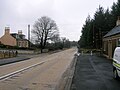
The place its maist deserted noo, there's just a hoose or twa,
The office and the store are doon, and they hinna left a raw.
I daunert up the road a wee, and stood and lucket roon,
I couldna see a soul about, nor could I hear a soon,
An o'the Den is gey sair chinged, frae the Den that I hae seen,
When the pits were gaun an' the wee Flit Baun an' a senior fitba
The House that Jack built's stinnin yet, but noo it is the Co.,
The wee shop that Allan kept is doon long long ago.
The big Lawn's gone an' the Cobblers Shop, and Granny Walkers work
An' the wee Schill Raw its doon an a', that stood fornent the kirk.
The Auld Hoose is stinnin yet, we kent it best by Pugs,
But there's no a buddy rinnin noo, wi bottles or wi jugs.
For noo its lost its license, an' there's no a drap ava,
Though miny a bottle has been selt, through the wee hole in the wa'.
Up on the know at last I sclimed, an' stood an' lucked roon,
On the Meidow Heid, the Maulside an' the dear auld Boolin Green.
Then I turned roon the ither way, an' see the same auld schill,
But there's no a wain gaun tae it noo, an' aw the place is still.
When we were callans at the schill, an' got our holidays,
We ran about the heather moss, or up on Rabbie's Braes.
An' in Bumbo we had a dook, or up some bing would sclim,
Then hungry we would hurry hame, an' doon the Cullhill rin.
The happy days have lang since gone, we're no sae young ye ken,
When past our sixtieth milestone we're nearing journeys end,
An' noo am feeling kinda stiff, bit a wis soople then,
When I played fitba in the MA Alley, wae the callants o' the Den.
Of the old folk I remember, like the hooses now all gone,
With their weird and wonderous nicknames, still their memory lingers.
There was Stulty Bell, an' Fish Kate, Laddelty an' Lum,
The Cobbler, The Butcher, The Sailor an' Pug Young.
There was Tam the warmer CooCoo, Pluffy Deans an' Tam the Baker,
Auld Ooorie, an' Bummer, now all gone to their Maker,
An' as I stand at the corner, as I do now an' then,
It makes me very proud to say, I was born in the DEN. [30]

Related Research Articles

Beith is a small town in the Garnock Valley, North Ayrshire, Scotland approximately 20 miles south-west of Glasgow. The town is situated on the crest of a hill and was known originally as the "Hill o' Beith" after its Court Hill.

<span class="mw-page-title-main">Brackenhills railway station</span> Disused railway station in Scotland

Brackenhills railway station was a railway station approximately one mile south-west of the town of Beith, close to Barkip, North Ayrshire, Scotland, part of the Lanarkshire and Ayrshire Railway.

<span class="mw-page-title-main">Barony and Castle of Giffen</span> Barony in the former District of Cunninghame, now North Ayrshire

The Barony of Giffen and its associated 15th-century castle were in the parish of Beith in the former District of Cunninghame, now North Ayrshire. The site may be spelled Giffen or Giffin and lay within the Lordship of Giffin, which included the Baronies of Giffen, Trearne, Hessilhead, Broadstone, Roughwood and Ramshead; valued at £3,788 9s 10d. The Barony of Giffen comprised a number of properties, including Greenhills, Thirdpart, Drumbuie, Nettlehirst and Balgray, covering about half of the parish of Beith. Giffen was a hundred merk land, separated from the Barony of Beith, a forty-pound land, by the Powgree Burn which rises on Cuff hill. The Lugton Water or the Bungle Burn running through Burnhouse may have been the Giffen barony boundary with that of the adjacent barony and lands of Aiket castle.

<span class="mw-page-title-main">Gateside, North Ayrshire</span> Human settlement in Scotland

Gateside is a small village in North Ayrshire, Scotland about 12 mile east of Beith on the B777.

<span class="mw-page-title-main">Barrmill, North Ayrshire</span> Small village in North Ayrshire, Scotland

Barrmill is a small village in North Ayrshire, Scotland about 1+12 miles east of Beith on the road to Burnhouse and Lugton. Locally it is known as the Barr.

<span class="mw-page-title-main">Highfield, North Ayrshire</span> Human settlement in Scotland

Highfield is a small village or hamlet in North Ayrshire, Parish of Dalry, Scotland. It is situated between the settlements of Barkip and Dalry on the A737 at a junction with the B777. It lies in the lands of the old Barony of Kersland, the ruins of Kersland Castle and East Kersland Mill being situated nearby at East Kersland.

<span class="mw-page-title-main">Spier's School</span> Building in North Ayrshire, Scotland

Spier's School (NS352533), at Beith, in North Ayrshire, Scotland was opened in 1888 and closed in 1972. The school, now demolished, was built using Ballochmyle red sandstone and was reminiscent of the ancient Glasgow University. The school motto was 'Quod verum tutum'. The gardens and woodlands are open to the public at all times.

<span class="mw-page-title-main">Geilsland House</span>

Geilsland House lies in between the village of Gateside and the town of Beith in North Ayrshire, Scotland. After serving as a private house it became a school and most recently (2015) has passed into the ownership of the Beith Development Community Trust.

<span class="mw-page-title-main">Broadstone Castle</span> Castle in Ayrshire, Scotland

Broadstone lies close to the small village of Gateside in North Ayrshire, Scotland about half a mile east of Beith in the old Barony of Giffen.

<span class="mw-page-title-main">Kilbirnie Loch</span> Lake in North Ayrshire, Scotland

Kilbirnie Loch is a freshwater Loch situated in the floodplain between Kilbirnie, Glengarnock and Beith, North Ayrshire, Scotland. It runs south-west to north-east for almost 2 km (1.2 mi), is about 0.5 km (0.31 mi) wide for the most part and has an area of roughly 3 km2. It has a general depth of around 5.2 metres to a maximum of around 11 metres. The loch is fed mainly by the Maich Water, which rises in the Kilbirnie Hills near Misty Law, and is drained by the Dubbs Water that runs past the Barr Loch into Castle Semple Loch, followed by the Black Cart, the White Cart at Renfrew and finally the River Clyde. The boundary between East Renfrewshire and North Ayrshire, in the vicinity of the loch, runs down the course of the Maich Water along the northern loch shore to then run up beside the Dubbs Water.

<span class="mw-page-title-main">Hill of Beith Castle</span>

The old Barony and castle, fortalice, or tower house of Hill of Beith lay in the feudal Regality of Kilwinning, within the Baillerie of Cunninghame, and the Sherrifdom of Ayr, now the Parish of Beith, North Ayrshire, Scotland.

<span class="mw-page-title-main">The Lands of Roughwood</span>

Roughwood once Ruchwood is a farm, originally a estate, possessing at one time a small tower castle. Roughwood is situated near to the town of Beith in North Ayrshire, Scotland; the lands lay within the old Lordship of Giffen.

<span class="mw-page-title-main">Greenhills, North Ayrshire</span> Human settlement in Scotland

Greenhills is a small village or hamlet in North Ayrshire, Parish of Beith, Scotland. It lies between the settlements of Barrmill and the hamlet of Burnhouse on a crossroads of the B706 and the lanes to Nettlehirst and Tandlehill via the Third part. It is named after the 'Green Hill' an artificial mound, a Moot, Law or Justice hill that once stood here. The settlement lay within the old Barony of Giffen; the castle no longer exists. The village lies within Barrmill and District Community Association's area and is also covered by Beith Community Council.

<span class="mw-page-title-main">Barony of Kersland</span>

The remains of the old castle of Kersland lie about 1.5 miles to the north-east of the town of Dalry in North Ayrshire, Scotland, in the old Barony of Kersland. The River Garnock lies nearby.

<span class="mw-page-title-main">Barony and Castle of Kilbirnie</span> Barony and castle west of the town of Kilbirnie in North Ayrshire, Scotland

The substantial remains of the old castle and sixteenth century manor house of Kilbirnie lie west of the town of Kilbirnie in North Ayrshire, Scotland, on the lower slopes of the Glengarnock Hills, in the old Barony of Kilbirnie. The building is also variously known as the Place of Kilbirnie, The Place, or Kilbirnie House.

Donald Lees ReidBA (Hons) is a Scottish author. He specialises in local and social history and has written books on the history of the Garnock Valley and Doon Valley, including the towns of Beith, Barrmill, Dalmellington, Gateside, Kilbirnie, Patna, and Waterside. He has resided in Beith, North Ayrshire since 1986. A strong emphasis in the books is on the people and the social context of their lives.

<span class="mw-page-title-main">Lands of Willowyard</span>

The ancient lands of Willowyard, Willieyeards, Williyard or Willizeards were part of the holdings of the Regality of Kilwinning, Barony of Beith, and Bailiary of Cuninghame. They later became the property of the Montgomerie family before being sold to the Simson family in 1723. The manor house still survives as part of a business premises and the nearby industrial estate and whisky bond carry the name 'Willowyards'.

<span class="mw-page-title-main">Lands of Marshalland</span>

The lands of Marshalland, Marsheland, Marsheyland or Marshyland were part of the holdings of the Barony of Beith, Regality of Kilwinning and Bailiary of Cuninghame. They became the property of the Lyle family, then the Shedden family, passing next to the Spier's family before finally becoming part of the Spier's Trust lands. The laird's house and farm were demolished in the 1960s.

<span class="mw-page-title-main">Lands of Morishill</span>

The lands of Morishill,Morrishill,Moorishill or Moricehill were part of the holdings of the Barony of Beith, Regality of Kilwinning and Bailiary of Cuninghame. The name may have derived from large shielings or huts that were once erected at the site.

<span class="mw-page-title-main">Lands of Threepwood</span>

The lands of Threepwood were located in the Parish of Beith, at the eastern boundary between East Renfrewshire and North Ayrshire, Scotland. The settlements of Midtown, Townhead and Townend were part of the old Threepwood Estate. Cuffhill at 675 feet is the highest eminence in the parish and it overlooks the area with Little Hill and Cuff Hill and Little Hill plantations nearby, now situated next to the entirely artificial Cuffhill Reservoir.

References

Notes

  1. 1 2 3 Reid (2001), p.105
  2. 1 2 Roy's Map Retrieved : 18 February 2012
  3. Mackay, John; Maclean, Annie; Mackay, Sharp (1892). The Celtic monthly: a magazine for Highlanders (Public domain ed.). Archibald Sinclair, Celtic Press. pp. 22–. Retrieved 19 February 2012.
  4. 1 2 3 4 5 Reid (2001), p. 119
  5. Dene (valley).
  6. Scots Dictionary Retrieved : 2012-02-20
  7. Dobie, Page 85
  8. McGeorge, Page 166
  9. Blaeu's Map Retrieved : 18 February 2012
  10. Scotland. Court of Session; William Maxwell Morison (1801). The decisions of the Court of Session: from its first institution to the present time : digested under proper heads, in the form of a dictionary. Bell. p. 326. Retrieved 19 February 2012.
  11. Rootsweb Retrieved : 2012-02-20
  12. Catalogue of the western Scottish fossils (Public domain ed.). Blackie. 1876. pp. 76–. Retrieved 19 February 2012.
  13. Geological Society of Glasgow (1868). Transactions of the Geological Society of Glasgow. Soc. p. 289. Retrieved 19 February 2012.
  14. Dalry History Group, Page 108
  15. Love, p.84
  16. Dalry Trinity Church Retrieved : 2012-05-27
  17. Three Towners Archived 2012-05-16 at the Wayback Machine Retrieved : 2012-05-27
  18. Reid (2001), p. 86
  19. Old Maps Archived April 30, 2012, at the Wayback Machine Retrieved : 2012-02-26]
  20. Dobie, Page 326
  21. 1 2 Love (2003), Page 84
  22. British Listed Buildings Retrieved : 2012-02-26
  23. Boyle, Andrew (1996). Ayrshire Book of Burns-Lore. Alloway Publishing. p. 102. ISBN   9780907526711.
  24. letsrecycle.com Retrieved : 2012-02-21
  25. "Barkip AD Plant Progress Update, 18/2/11". William Tracey Ltd. 18 February 2011. Archived from the original on 11 July 2012. Retrieved 20 February 2012.
  26. Reid, Chapter 3
  27. Blackmar, Frank Wilson (1912). Kansas: a cyclopedia of state history, embracing events, institutions, industries, counties, cities, towns, prominent persons, etc. ... with a supplementary volume devoted to selected personal history and reminiscence (Public domain ed.). Standard publishing company. pp. 482–. Retrieved 19 February 2012.
  28. M'Kie, James (1867). Title pages, and imprints, of the books in the private library of James M'Kie, Kilmarnock. p. 55. Retrieved 19 February 2012.
  29. Family Search Retrieved : 2012-02-26
  30. Kinniburgh, Page 103

Sources

  • Dalry History Group (1985). Dalry Remembered. ISBN   0-9510674-0-0.
  • Dobie, James D. (ed Dobie, J.S.) (1876). Cunninghame, Topographized by Timothy Pont 1604–1608, with continuations and illustrative notices. Glasgow: John Tweed.
  • Kinniburgh, Moira and Burke, Fiona (1995). Kilbirnie and Glengarnock. Shared Memories. Kilbirnie Library. ISBN   1-897998-01-5.
  • Love, Dane (2003). Ayrshire : Discovering a County. Ayr : Fort Publishing. ISBN   0-9544461-1-9.
  • McMichael, George. Notes on the Way. Ayr : Hugh Henry.
  • Reid, Donald L. (2001). In the Valley of Garnock. Beith : D. Reid & the Jolly Beggars Burns Club. ISBN   0-9522720-6-7.
  • Reid, Donald L. (2011). Beith, Barrmill and Gateside. Beith : D. Reid & the Jolly Beggars Burns Club. ISBN   978-0-9566343-1-3.
  • Reid, Donald & Monahan, Isobel F. (1999). Yesterday's Beith. Beith : DoE. ISBN   0-9522720-5-9.