Shiskine
| |
---|---|
Location within North Ayrshire | |
OS grid reference | NR911298 |
Civil parish |
|
Council area | |
Lieutenancy area | |
Country | Scotland |
Sovereign state | United Kingdom |
Post town | ISLE OF ARRAN |
Postcode district | KA27 |
Dialling code | 01770 |
Police | Scotland |
Fire | Scottish |
Ambulance | Scottish |
UK Parliament | |
Scottish Parliament | |
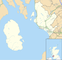
Shiskine (Scottish Gaelic : An t-Seasgann) is a small village on the Isle of Arran in the Firth of Clyde, Scotland. The village is within the parish of Kilmory. [1] Sitting further up the "Shiskine Valley" from the village of Blackwaterfoot, the village takes its name from a corruption of the Gaelic for "marshy place". Much of the area was essentially a swamp years ago, but now comprises farm land.
The village has its own primary school [2] and local church. [3] There is a possible hillfort at Cnoc Ballygowan close by to the village, though its antiquity is disputed. [4] Shiskine is close to the peaks of Beinn Nuis and Beinn Bharrain.
Thornhill is a village in the Scottish council area of Stirling. It lies 14 miles north west of Stirling itself, south of Callander, east of Aberfoyle and west of Doune.
Blackwaterfoot is a village on the Isle of Arran in the Firth of Clyde, Scotland. The village is within the parish of Kilmory. It is located in the Shiskine valley in the south-west of the island. It is one of the smaller villages of Arran and home to one of Europe's two 12-hole golf courses. Nearby Drumadoon Point is home to the largest Iron Age fort on Arran. Further north is the King's Cave, reputed to be a hiding place of Robert the Bruce.
Rodel is a village on the south-eastern coast of Harris, an island in the Scottish Outer Hebrides. Rodel is situated in the parish of Harris. It was historically the capital of Harris, and the main port, before Tarbert took the title.
Shawbost is a large village in the West Side of the Isle of Lewis. The village of Shawbost has a population of around 500 and lies around 20 miles west of Lewis's capital Stornoway. Shawbost is within the parish of Barvas. A recent development in the village was the renovation of the old school into the new community centre. The scattered settlement is split into three sections: North Shawbost, South Shawbost and New Shawbost. There is a small museum of folk life and nearby is a small stone circle. The village is overlooked by a small hill named Beinn Bhragair, 261 m high. Shawbost is a prominent village on the Isle of Lewis, due to the school, community centre, beach and Harris Tweed mill.
Bragar is a village on the west side of the Isle of Lewis in the Outer Hebrides, Scotland, 14 miles from the island's only town, Stornoway. Bragar is within the parish of Barvas, and is situated on the A858 between Carloway and Barvas.
Carloway is a crofting township and a district on the west coast of the Isle of Lewis, in the Outer Hebrides, Scotland. The district has a population of around 500. Carloway township is within the parish of Uig, and is situated on the A858.
Tarbert is the main community on Harris in the Western Isles of Scotland. The name means "isthmus", "crossing point" or "portage", in Gaelic. The isthmus, between the sea lochs West Loch Tarbert and East Loch Tarbert, joins south Harris to north Harris and Lewis. In 1981 it had a population of 503.
Carinish, is a hamlet on North Uist, in the Outer Hebrides, Scotland. It is in the south of the island, about two miles from the causeway to Benbecula. The hamlet is known for the Carinish Stone Circle and the Trinity Temple. Carinish is within the parish of North Uist and is situated on the A865.
Skigersta is a village to the south east of Ness on the Isle of Lewis, in the Outer Hebrides, Scotland. It is the easternmost settlement in the Ness district and is 5km (3miles) southeast of the Butt of Lewis. Skigersta is situated within the parish of Barvas. There is a quay built in 1901 and a shingle beach. The area of Skigersta near the shore is called 'Lachamore'. To the south of Skigersta the moor begins and the road turns into a peat track; there are sheilings on the moor at Cuisiadar and if you follow the moor further south you reach the road at New Tolsta.
Breasclete is a village and community on the west side of the Isle of Lewis, in the Outer Hebrides, Scotland. Breasclete is within the parish of Uig, and is situated adjacent to the A858.
Kilmory is a small village on the south coast of the Isle of Arran, located on the coastal road between Lagg and Kildonan. Kilmory is also the parish of the western side of the Isle of Arran.
Sliddery is a tiny hamlet located on the Southwest coast of the Isle of Arran in Scotland. The village is situated near the Ross road between Lagg and Blackwaterfoot.
Sannox is a village on the Isle of Arran, Scotland. The village is within the parish of Kilbride. The name comes from the name the Vikings gave to the area, Sandvik, meaning the Sandy Bay.
Brevig is a village on the island of Barra, in the Outer Hebrides, Scotland. The settlement is situated on the A888, which is Barra's circular main road. Brevig is also within the parish of Barra.
Knockaird is a village on the Isle of Lewis in the parish of Ness, in the Outer Hebrides, Scotland. It is the highest point in Port of Ness and is home to Dùn Èistean an ancient ruined fort on a small island that is joined by a bridge. Dùn Èistean is traditionally known as a stronghold of the Clan Morrison of Lewis. Knockaird is within the parish of Barvas. The B8014 travels through the settlement, between Port of Ness and Eoropie. The Clach Stein standing stones are situated between Knockaird and Port of Ness.
Timsgarry is a village on the Isle of Lewis, in the Outer Hebrides, Scotland. Timsgarry is home to the Baile na Cille Church and the Uig Museum, noted for its giant Chessmen, discovered in the sands in 1831.
Brue is a village on the Isle of Lewis in the West Side district, in the Outer Hebrides, Scotland. It is a crofting township and it is composed of two areas: Am Baile Staigh, which is nearer the coast, and Pàirc Bhrù, which runs towards the moor. In total it covers a road distance of 2.5 km. Brue is situated on a minor road which joins to the A858, and is within the parish of Barvas.
The Isle of Arran or simply Arran is an island off the west coast of Scotland. It is the largest island in the Firth of Clyde and the seventh-largest Scottish island, at 432 square kilometres (167 sq mi). Historically part of Buteshire, it is in the unitary council area of North Ayrshire. In the 2011 census it had a resident population of 4,629. Though culturally and physically similar to the Hebrides, it is separated from them by the Kintyre peninsula. Often referred to as "Scotland in Miniature", the Island is divided into highland and lowland areas by the Highland Boundary Fault and has been described as a "geologist's paradise".
Eynort is a small remote hamlet, situated at the head of Loch Eynort, on the west coast of the Isle of Skye, Scottish Highlands and is in the Scottish council area of Highland. The ruins of a chapel dedicated to St Maelrubha are located at Eynort.