Whitefarland
| |
---|---|
The view from Whitefarland point to Kintyre | |
Location within North Ayrshire | |
OS grid reference | NR864421 |
Civil parish |
|
Council area | |
Lieutenancy area | |
Country | Scotland |
Sovereign state | United Kingdom |
Post town | ISLE OF ARRAN |
Postcode district | KA27 |
Dialling code | 01770 |
Police | Scotland |
Fire | Scottish |
Ambulance | Scottish |
UK Parliament | |
Scottish Parliament | |
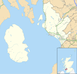
Whitefarland (Scottish Gaelic : An Aoirinn) is a clachan on the Isle of Arran in the Firth of Clyde, Scotland. It is located approximately 1 mile (2 kilometres) to the south of Pirnmill. Its name is derived from Old Norse, not Gaelic. It may refer to Olaf the White who was King of Ireland and the Western Isles. The alternative name for Whitefarland, cited in 1351 in papers in the Scottish Records is 'Irachonan' - which means King of Ireland in old Norse.
The Islands of the Firth of Clyde are the fifth largest of the major Scottish island groups after the Inner and Outer Hebrides, Orkney and Shetland. They are situated in the Firth of Clyde between Argyll and Bute in the west and Inverclyde, North Ayrshire and South Ayrshire in the east. There are about forty islands and skerries. Only four are inhabited, and only nine are larger than 40 hectares. The largest and most populous are Arran and Bute. They are served by dedicated ferry routes, as are Great Cumbrae and Holy Island. Unlike the isles in the four larger Scottish archipelagos, none of the isles in this group are connected to one another or to the mainland by bridges.
Brodick is the main village on the Isle of Arran, in the Firth of Clyde, Scotland. It is halfway along the east coast of the island, in Brodick Bay below Goat Fell, the tallest mountain on Arran. The name is derived from the Norse "breda-vick" meaning "Broad Bay".
The Kingdom of the Isles, also known as Sodor was a Norse-Gaelic kingdom comprising the Isle of Man, the Hebrides and the islands of the Clyde from the 9th to the 13th centuries AD. The islands were known to the Norsemen as the Suðreyjar, or "Southern Isles" as distinct from the Norðreyjar or Northern Isles of Orkney and Shetland. In Scottish Gaelic, the kingdom is known as Rìoghachd nan Eilean. The territory is sometimes called the Kingdom of Mann and the Isles, although only some of the later rulers claimed that title. The historical record is incomplete, and the kingdom was not a continuous entity throughout the entire period. At times the rulers were independent of external control, although for much of the period they had overlords in Norway, Ireland, England, Scotland or Orkney. At times there also appear to have been competing claims for all or parts of the territory. The islands have a total land area of over 8,300 square kilometres (3,205 sq mi) and extend for more than 500 kilometres (310 mi) from north to south.
Blackwaterfoot is a village on the Isle of Arran in the Firth of Clyde, Scotland. The village is within the parish of Kilmory. It is located in the Shiskine valley in the south-west of the island. It is one of the smaller villages of Arran and home to one of Europe's two 12-hole golf courses. Nearby Drumadoon Point is home to the largest Iron Age fort on Arran. Further north is the King's Cave, reputed to be a hiding place of Robert the Bruce.
Lord of the Isles or King of the Isles (Scottish Gaelic: Triath nan Eilean or Rìgh Innse Gall; Latin: Dominus Insularum) is a title of nobility in the Baronage of Scotland with historical roots that go back beyond the Kingdom of Scotland. It began with Somerled in the 12th century and thereafter the title was held by a series of his descendants, the Norse-Gaelic rulers of the Isle of Man and Argyll and the islands of Scotland in the Middle Ages. They wielded sea-power with fleets of galleys (birlinns). Although they were, at times, nominal vassals of the kings of Norway, Ireland, or Scotland, the island chiefs remained functionally independent for many centuries. Their territory included much of Argyll, the Isles of Arran, Bute, Islay, the Isle of Man, Hebrides, Knoydart, Ardnamurchan, and the Kintyre peninsula. At their height they were the greatest landowners and most powerful lords after the kings of England and Scotland.
Galwegian Gaelic is an extinct dialect of Scottish Gaelic formerly spoken in southwest Scotland. It was spoken by the people of Galloway and Carrick until the early modern period. Little has survived of the dialect, so that its exact relationship with other Goidelic languages is uncertain.
The Norse–Gaels were a people of mixed Gaelic and Norse ancestry and culture. They emerged in the Viking Age, when Vikings who settled in Ireland and in Scotland became Gaelicised and intermarried with Gaels. The Norse–Gaels dominated much of the Irish Sea and Scottish Sea regions from the 9th to 12th centuries. They founded the Kingdom of the Isles, the Kingdom of Dublin, the Lordship of Galloway, and briefly ruled the Kingdom of York. The most powerful Norse–Gaelic dynasty were the Uí Ímair or House of Ivar.
Corrie is a village on the north east coast of the Isle of Arran in Scotland, 6 miles north of Brodick. It lies 2 mi (3 km) due east under the island's highest mountain, Goat Fell. A path from High Corrie 3⁄4 mi (1.2 km) to the south, provides access to the hillside. Corrie, and its northern neighbour, Sannox, lie approximately halfway between Brodick and Lochranza.
Kilmory is a small village on the south coast of the Isle of Arran, located on the coastal road between Lagg and Kildonan. Kilmory is also the parish of the western side of the Isle of Arran.
Sliddery is a tiny hamlet located on the Southwest coast of the Isle of Arran in Scotland. The village is situated near the Ross road between Lagg and Blackwaterfoot.
Shiskine is a small village on the Isle of Arran in the Firth of Clyde, Scotland. The village is within the parish of Kilmory. Sitting further up the "Shiskine Valley" from the village of Blackwaterfoot, the village takes its name from a corruption of the Gaelic for "marshy place". Much of the area was essentially a swamp years ago, but now comprises farm land.
Pirnmill is a small village on the north-west coast of the island of Arran, Scotland. The village is situated on the Kilbrannan Sound, facing Grogport on the Kintyre peninsula.
Sannox is a village on the Isle of Arran, Scotland. The village is within the parish of Kilbride. The name comes from the name the Vikings gave to the area, Sandvik, meaning the Sandy Bay.
Note: Cladach is a general Scottish Gaelic word for "beach" or "shore" and occurs in many Scottish placenames
Lagg is a hamlet on southern coast of the Isle of Arran in Scotland made up of a few houses and a hotel. The hamlet is within the parish of Kilmory.
The Isle of Arran or simply Arran is an island off the west coast of Scotland. It is the largest island in the Firth of Clyde and the seventh-largest Scottish island, at 432 square kilometres (167 sq mi). Historically part of Buteshire, it is in the unitary council area of North Ayrshire. In the 2011 census it had a resident population of 4,629. Though culturally and physically similar to the Hebrides, it is separated from them by the Kintyre peninsula. Often referred to as "Scotland in Miniature", the Island is divided into highland and lowland areas by the Highland Boundary Fault and has been described as a "geologist's paradise".
The etymology of Skye attempts to understand the derivation of the name of the Isle of Skye in the Inner Hebrides of Scotland. Skye's history includes the influence of Gaelic, Norse and English speaking peoples, and the relationships between their names for the island are not straightforward. Ultimately, like other Scottish locations as Islay, Lewis and Arran, the origin of the name is still debated and may be impossible to discern with all known evidence.
Dervaig is a small village on the Isle of Mull off the west coast of Scotland. The village is within the parish of Kilninian and Kilmore, and is situated on the B8073 roughly midway between Tobermory and Calgary. In 1961 it had a population of 82.
The modern names of Scottish islands stem from two main influences. There are many names that derive from the Scottish Gaelic language in the Hebrides and Firth of Clyde. In the Northern Isles most place names have a Norse origin. There are also some island place names that originate from three other influences, including a limited number that are essentially English language names, a few that are of Brittonic origin and some of an unknown origin that may represent a pre-Celtic language. These islands have all been occupied by the speakers of at least three and in many cases four or more languages since the Iron Age, and many of the names of these islands have more than one possible meaning as a result.
Scandinavian Scotland was the period from the 8th to the 15th centuries during which Vikings and Norse settlers, mainly Norwegians and to a lesser extent other Scandinavians, and their descendants colonised parts of what is now the periphery of modern Scotland. Viking influence in the area commenced in the late 8th century, and hostility between the Scandinavian earls of Orkney and the emerging thalassocracy of the Kingdom of the Isles, the rulers of Ireland, Dál Riata and Alba, and intervention by the crown of Norway were recurring themes.