Machrie

Last updated

Machrie
Standing stones at Machrie Moor, Scotland -16Feb2011.jpg
One of the standing stones on the moor
North Ayrshire UK location map.svg
Red pog.svg
Machrie
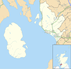
Location within North Ayrshire
OS grid reference NR891345
Civil parish
  • Kilmory
Council area
Lieutenancy area
Country Scotland
Sovereign state United Kingdom
Post town ISLE OF ARRAN
Postcode district KA27
Dialling code 01770
Police Scotland
Fire Scottish
Ambulance Scottish
UK Parliament
Scottish Parliament
List of places
UK
Scotland
55°33′32″N5°20′38″W / 55.559°N 5.344°W / 55.559; -5.344 Coordinates: 55°33′32″N5°20′38″W / 55.559°N 5.344°W / 55.559; -5.344

Machrie (Scottish Gaelic : Am Machaire) is a village on the Isle of Arran in the Firth of Clyde, Scotland. Machrie Bay can be found on the West Coast. The village is within the parish of Kilmory. [1]

Contents

It is most well known for its Standing Stones that are a local tourist attraction, along with the King's Cave which was believed to have been used by Robert the Bruce.
Machrie Moor

Machrie Moor is the site of a number of neolithic structures dating back up to 4500 years ago. These include the six Machrie Moor Stone Circles, and Moss Farm Road Stone Circle. The standing stones were dated back to approximately 2500 years ago but excavations in the 1980s uncovered elaborate timber structures and stone circles which dated back even further in history.

Related Research Articles

Ring of Brodgar A neolithic stone circle in Orkney, Scotland

The Ring of Brodgar is a Neolithic henge and stone circle about 6 miles north-east of Stromness on Mainland, the largest island in Orkney, Scotland. It is part of the UNESCO World Heritage Site known as the Heart of Neolithic Orkney.

County of Bute Historic county in Scotland

The County of Bute, also known as Buteshire, is a historic county and registration county of Scotland.

Prehistoric Scotland

Archaeology and geology continue to reveal the secrets of prehistoric Scotland, uncovering a complex past before the Romans brought Scotland into the scope of recorded history. Successive human cultures tended to be spread across Europe or further afield, but focusing on this particular geographical area sheds light on the origin of the widespread remains and monuments in Scotland, and on the background to the history of Scotland.

The Hurlers (stone circles) Group of three stone circles in Cornwall, England

The Hurlers is a group of three stone circles in the civil parish of St Cleer, Cornwall, England, UK. The site is half-a-mile (0.8 km) west of the village of Minions on the eastern flank of Bodmin Moor, and approximately four miles (6 km) north of Liskeard at grid reference SX 258 714.

Callanish Stones

The Callanish Stones are an arrangement of standing stones placed in a cruciform pattern with a central stone circle. They were erected in the late Neolithic era, and were a focus for ritual activity during the Bronze Age. They are near the village of Callanish on the west coast of Lewis in the Outer Hebrides, Scotland.

Shulishader Human settlement in Scotland

Shulishader is a small village with a population of around 120 people in Point, Outer Hebrides on the Isle of Lewis, Scotland. Located on the north-western side of the Eye Peninsula, it overlooks Broad Bay. Most of the village is over 60m above sea level, affording excellent views across the bay and northern Lewis, though the land falls gently towards the sea before ending in small cliffs. There are several small, difficult to access, sandy beaches, and a small cove on the coastline. The cove is accessible via 88 dilapidated steps, and contains a pebble peach, some natural caves and a concrete structure once used for boat moorings above the high tide line.

Ballymeanoch

Ballymeanoch is a complex of neolithic structures located in Kilmartin Glen, Scotland.

Doll Tor Bronze age stone circle in Derbyshire

Doll Tor is a stone circle located just to the west of Stanton Moor, near the village of Birchover, Derbyshire in the English East Midlands. Doll Tor is part of a tradition of stone circle construction that spread throughout much of Britain, Ireland, and Brittany during the Late Neolithic and Early Bronze Ages, over a period between 3300 and 900 BCE. The purpose of such monuments is unknown, although archaeologists speculate that the stones represented supernatural entities for the circles' builders.

Drybridge is a small village in North Ayrshire, Scotland. Drybridge is thus named because of the "dry bridge" over the Kilmarnock and Troon Railway, opened in 1812. The nearby "wet bridge" is the Laigh Milton Viaduct, the oldest surviving railway bridge in Scotland and possibly the world.

Clach an Trushal

Clach an Trushal is said to be the tallest standing stone in Scotland. Above ground it stands approximately 5.8 metres tall, is 1.83 m wide and at its thickest point is 1.5 m thick, with a girth at its base of 4.75 m. The stone is sited in the village of Ballantrushal on the west side of Lewis. Local legend says that it marks the site of a great battle, the last to be fought between the feuding clans of the Macaulays and Morrisons. However it is actually the solitary upright stone remaining from a stone circle built about 5,000 years ago. It occupied a place within the circle, although its placement was not central. The second last standing stone was removed in 1914, and used as a lintel.

History of the Outer Hebrides

The Hebrides were settled early on in the settlement of the British Isles, perhaps as early as the Mesolithic era, around 8500–8250 BC, after the climatic conditions improved enough to sustain human settlement. There are examples of structures possibly dating from up to 3000 BC, the finest example being the standing stones at Callanish, but some archaeologists date the site as Bronze Age. Little is known of the people who settled in the Hebrides but they were likely of the same Celtic stock that had settled in the rest of Scotland. Settlements at Northton, Harris, have both Beaker & Neolithic dwelling houses, the oldest in the Western Isles, attesting to the settlement.

Glasserton Human settlement in Scotland

Glasserton is a civil parish in Dumfries and Galloway, south-west Scotland. It is on the Machars peninsula, in the traditional county of Wigtownshire. The parish is about 8 miles (13 km) in length, varying in breadth from 1 to 3 miles, and contains 13,477 acres (54.54 km2).

Prehistoric Orkney

Prehistoric Orkney refers only to the prehistory of the Orkney archipelago of Scotland that begins with human occupation. Although some records referring to Orkney survive that were written during the Roman invasions of Scotland, “prehistory” in northern Scotland is defined as lasting until the start of Scotland’s Early Historic Period (around AD 600.

Isle of Arran Island off the coast of Scotland

The Isle of Arran or simply Arran is an island off the west coast of Scotland. It is the largest island in the Firth of Clyde and the seventh largest Scottish island, at 432 square kilometres (167 sq mi). Historically part of Buteshire, it is in the unitary council area of North Ayrshire. In the 2011 census it had a resident population of 4,629. Though culturally and physically similar to the Hebrides, it is separated from them by the Kintyre peninsula. Often referred to as "Scotland in Miniature", the island is divided into highland and lowland areas by the Highland Boundary Fault and has been described as a "geologist's paradise".

Machrie golf course

The Machrie Golf Course, or "The Machrie Links", is located on Islay, in Scotland. The word "machrie" is a corruption of the Scottish Gaelic machair, which means more or less the same as "links" did on the east coast of Scotland.

Machrie Moor Stone Circles

Machrie Moor Stone Circles is the collective name for six stone circles visible on Machrie Moor near the settlement of Machrie on the Isle of Arran, Scotland.

Architecture of Scotland in the Prehistoric era Buildings of Scotland in the Prehistoric era

The architecture of Scotland in the prehistoric era includes all human building within the modern borders of Scotland, before the arrival of the Romans in Britain in the first century BCE. Stone Age settlers began to build in wood in what is now Scotland from at least 8,000 years ago. The first permanent houses of stone were constructed around 6,000 years ago, as at Knap of Howar, Orkney and settlements like Skara Brae. There are also large numbers of chambered tombs and cairns from this era, particularly in the west and north. In the south and east there are earthen barrows, often linked to timber monuments of which only remnants remain. Related structures include bank barrows, cursus monuments, mortuary enclosures and timber halls. From the Bronze Age there are fewer new buildings, but there is evidence of crannogs, roundhouses built on an artificial islands and of Clava cairns and the first hillforts. From the Iron Age there is evidence of substantial stone Atlantic roundhouses, which include broch towers, smaller duns. There is also evidence of about 1,000 hillforts in Scotland, most located below the Clyde-Forth line.

Auchagallon Stone Circle

Auchagallon Stone Circle or Auchengallon cairn is the remains of a Neolithic or Bronze Age burial cairn, surrounded by a circle of fifteen stones. It is located near Machrie on the Isle of Arran in Scotland.

Moss Farm Road Stone Circle

Moss Farm Road Stone Circle is the remains of a Bronze Age burial cairn, surrounded by a circle of stones. It is located near Machrie on the Isle of Arran in Scotland.

References

  1. "Details of Machrie". Scottish Places. Retrieved 30 December 2014.