Sliddery

Last updated

Sliddery
Sliddery Water ford & Burnside Cottage (geograph 3301998).jpg
Sliddery Water ford and Burnside Cottage
North Ayrshire UK location map.svg
Red pog.svg
Sliddery
Location within North Ayrshire
OS grid reference NR930229
Civil parish
  • Kilmory
Council area
Lieutenancy area
Country Scotland
Sovereign state United Kingdom
Historic county
Post town ISLE OF ARRAN
Postcode district KA27
Dialling code 01770
Police Scotland
Fire Scottish
Ambulance Scottish
UK Parliament
Scottish Parliament
List of places
UK
Scotland
55°27′25″N5°16′23″W / 55.457°N 5.273°W / 55.457; -5.273 Coordinates: 55°27′25″N5°16′23″W / 55.457°N 5.273°W / 55.457; -5.273
World War I (and II) memorial between Sliddery and Lagg at the Ross Road intersection. Scotland, Isle of Arran, World War I Memorial.JPG
World War I (and II) memorial between Sliddery and Lagg at the Ross Road intersection.

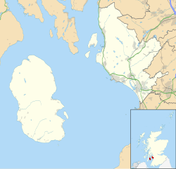
Sliddery (Gaelic: Slaodraidh) is a tiny hamlet located on the Southwest coast of the Isle of Arran in Scotland. The village is situated near the Ross road between Lagg and Blackwaterfoot.

The name Sliddery is thought to have been derived from the Gaelic denoting dragging or trailing, but another story has it that it was here that a band of marauding Vikings were butchered when attempting to settle in Sliddery Water valley and that the name has something to do with slaughter or massacre.

Nowadays, the hamlet sits upon the hill high above the estuary, about 12 mile (800 metres) from the shore. Various lanes lead down to a pebble beach, which offers views across the Kilbrannan Sound to Ireland and Ailsa Craig.

Related Research Articles

Brodick town in Scotland

Brodick is the main town on the Isle of Arran, in the Firth of Clyde, Scotland. It is halfway along the east coast of the island, in Brodick Bay below Goat Fell, the tallest mountain on Arran. The name is derived from the Norse "breda-vick" meaning "Broad Bay".

Blackwaterfoot Human settlement in Scotland

Blackwaterfoot " bottom [ of ] the black river " is a village on the Isle of Arran in the Firth of Clyde, Scotland. The village is within the parish of Kilmory. It is located in the Shiskine valley in the south-west of the island. It is one of the smaller villages of Arran and home to one of Europe's two 12-hole golf courses. A short walk from Blackwaterfoot is Drumadoon Point, home to the largest Iron Age fort on Arran. Further North is the King's Cave, reputed to be a hiding place of Robert the Bruce.

Calgary, Mull Human settlement in Scotland

Calgary is a hamlet on the northwest coast of the Isle of Mull, in Argyll and Bute, Scotland, United Kingdom. The hamlet is within the parish of Kilninian and Kilmore. It was the origin of the name of Fort Calgary in Canada, which became the city of Calgary, Alberta.

Port Bannatyne Human settlement in Scotland

Port Bannatyne is a coastal village on the Isle of Bute, Firth of Clyde, Scotland. Port Bannatyne developed into the 1900s as a quieter alternative to Rothesay. It is a popular harbour, with a small yacht marina and boatyard and an unusual 13-hole golf course rather than the standard 18.

Carradale Human settlement in Scotland

Carradale is a village on the east side of Kintyre, overlooking the Kilbrannan Sound and the west coast of the Isle of Arran in the Firth of Clyde, approximately 14 miles from Campbeltown. To the north of Carradale is the coastal peak known as Torr Mor; nearby are the hamlet of Dippen and Dippen Bay. Population: 578~ (2021)

Barvas Settlement, community and civil parish on the Isle of Lewis in Scotland

Barvas is a settlement, community and civil parish on the Isle of Lewis in Scotland.

Claonaig Human settlement in Scotland

Claonaig is a hamlet on the east coast of the Kintyre peninsula in western Scotland, linked to Lochranza on the Isle of Arran by the CalMac ferry MV Catriona in the summer months.

Corrie, Arran Human settlement in Scotland

Corrie is a village on the north east coast of the Isle of Arran in Scotland, 6 miles north of Brodick. It lies 2 mi (3 km) due east under the island's highest mountain, Goat Fell. A path from High Corrie 34 mi (1.2 km) to the south, provides access to the hillside. Corrie, and its northern neighbour, Sannox, lie approximately halfway between Brodick and Lochranza.

Kilmory, Arran Human settlement in Scotland

Kilmory is a small village on the south coast of the Isle of Arran, located on the coastal road between Lagg and Kildonan. Kilmory is also the parish of the western side of the Isle of Arran.

Shiskine Human settlement in Scotland

Shiskine is a small village on the Isle of Arran in the Firth of Clyde, Scotland. The village is within the parish of Kilmory. Sitting further up the "Shiskine Valley" from the village of Blackwaterfoot, the village takes its name from a corruption of the Gaelic for "marshy place". Much of the area was essentially a swamp years ago, but now comprises farm land.

Ardeonaig Human settlement in Scotland

Ardeonaig is a hamlet on the southern shore of Loch Tay in the Stirling Council area of Scotland. It is approximately 7 miles east of Killin and lies at the mouth of the Ardeonaig Burn where it enters Loch Tay.

Pirnmill Human settlement in Scotland

Pirnmill is a small village on the north-west coast of the Isle of Arran, Scotland. The village is situated on the Kilbrannan Sound, facing Grogport on the Kintyre peninsula.

Sannox Human settlement in Scotland

Sannox is a village on the Isle of Arran, Scotland. The village is within the parish of Kilbride. The name comes from the name the Vikings gave to the area, Sandvik, meaning the Sandy Bay.

Cladach Human settlement in Scotland

Note: Cladach is a general Scottish Gaelic word for "beach" or "shore" and occurs in many Scottish placenames

Lagg, Arran Human settlement in Scotland

Lagg is a hamlet on southern coast of the Isle of Arran in Scotland made up of a few houses and a hotel. The hamlet is within the parish of Kilmory.

Arnprior, Stirling Human settlement in Scotland

Arnprior is a hamlet in the Stirling council area of Scotland on the A811 about 12 miles west of Stirling and is one of the smallest community council districts in the region. The hamlet is next to the Flanders Moss National Nature Reserve and close to the east boundary of the Loch Lomond and Trossachs National Park, which includes the Lake of Menteith.

Whitefarland Human settlement in Scotland

Whitefarland is a clachan on the Isle of Arran in the Firth of Clyde, Scotland. It is located approximately 1 mile to the south of Pirnmill.

Isle of Arran Island off the coast of Scotland

The Isle of Arran or simply Arran is an island off the west coast of Scotland. It is the largest island in the Firth of Clyde and the seventh largest Scottish island, at 432 square kilometres (167 sq mi). Historically part of Buteshire, it is in the unitary council area of North Ayrshire. In the 2011 census it had a resident population of 4,629. Though culturally and physically similar to the Hebrides, it is separated from them by the Kintyre peninsula. Often referred to as "Scotland in Miniature", the island is divided into highland and lowland areas by the Highland Boundary Fault and has been described as a "geologist's paradise".

Eynort Human settlement in Scotland

Eynort is a small remote hamlet, situated at the head of Loch Eynort, on the west coast of the Isle of Skye, Scottish Highlands and is in the Scottish council area of Highland. The ruins of a chapel dedicated to St. Maelrubha are located at Eynort.

Cat Stones of Scotland

The Cat Stones of Scotland are natural prominent rock features or standing stones around Scotland that are often linked to battles or burials. The English term cat applied to such stones derives from the Gaelic cath. Clach a'Chait would be the Gaelic for "Stone of the Cat".