Gateside, North Ayrshire

Last updated

Gateside
Gateside Primary school.JPG
Gateside Primary School
North Ayrshire UK location map.svg
Red pog.svg
Gateside
Location within North Ayrshire
Council area
Lieutenancy area
Country Scotland
Sovereign state United Kingdom
Dialling code 01505
Police Scotland
Fire Scottish
Ambulance Scottish
UK Parliament
Scottish Parliament
List of places
UK
Scotland
55°44′N4°37′W / 55.74°N 4.61°W / 55.74; -4.61 Coordinates: 55°44′N4°37′W / 55.74°N 4.61°W / 55.74; -4.61

Gateside is a small village in North Ayrshire, Scotland about 12 mile (800 metres) east of Beith on the B777.

Contents

The village

Gateside Primary School was opened in 1903, and nowadays it has 74 pupils (2009). The school has an extension built in 1998 which provided indoor toilets and a school hall, which is used by the nursery, PE classes, and for school dinners and assemblies. Another extension is to be built soon. The school is very environmentally aware and has achieved its Green Flag Award (2009). Spier's school stood nearby and the grounds are now a public park used by the Gateside and Beith communities.

The Isabel Patrick Memorial Hall is a building in the Gothic style. Trearne House stood near Gateside, but it was demolished and the site is now a large worked out limestone quarry.

A field behind the primary school was given to the community by the Marshall family who were the village blacksmiths for many years.

The meaning of Powgree, Gateside's burn, is suggested as being 'Stream of the herd (of deer)'. [1]

Views of Gateside

The Court Hill

Gateside from the Hill of Beith old farm site Gateside from Beith Hill.JPG
Gateside from the Hill of Beith old farm site
The Court Hill of the Abbot of Kilwinning near the village Beith Court Hill 1.JPG
The Court Hill of the Abbot of Kilwinning near the village

A Moot hill or Court Hill survives near Gateside at Bog hall in the old Barony of Beith. Dobie states that the Abbot of Kilwinning used it to administered justice to his vassals & tenants. It is a sub-oval, flat-topped mound, situated at the foot of a small valley. A number of large stones are visible in the sides of the mound. It is turf-covered, situated on a low outcrop, and is mostly an artificial work. It pre-dates the channelling of the Boghall Burn which detours around it, the mound was probably isolated in this once marshy outflow of the former Boghall Loch (see NS35SE 14). [2] Hill of Beith Castle, a square tower castle, once held by the Cunninghame family, stood near to the moot hill. [3]

Boghall Loch

Loch Brand or Bran was the name by which Boghall Loch was formerly known. The loch, drained in 1780, is one of the main sources of the Powgree Burn and lay on the lands of Boghall and Hill o'Beith. In the bottom of the loch piles, stakes of oak or elm have been found and it is thought that these may be the remains of crannogs. [4] [5] The site is now represented by a low, marsh and reed covered area (less than 2 ha in extent) centred at NS 358 543 on the OS map. [6]

The loch was once the property of the monks of Kilwinning Abbey and it is recorded that in 1482 the monks took legal action against the Montgomeries of Giffin Castle and James Ker who were accused of dangerous destruction and down-casting of the fosses and dikes of the loch called Loch Brand. [7] It is not recorded what effect these actions had upon the size and depth of the loch.

Boghall Farm

This old habitation, marked as Boighall on a 1654 map, [8] was the home to the mother, Janet Pollock, of Robert Tannahill the 'Weaver Poet'. [9]

Limestone and marble

The drained Boghall Loch above Gateside, source of the Powgree Burn The site of the old Boghall Loch.JPG
The drained Boghall Loch above Gateside, source of the Powgree Burn
The old Crooked Dam millpond site on the Powgree Burn in the Fairy Glen Fairy Glen on the Powgree, Gateside.JPG
The old Crooked Dam millpond site on the Powgree Burn in the Fairy Glen

The underlying geology of this part of Ayrshire is such that the presence of limestone quarries is to be expected. Lime kilns to produce quicklime for improving the soil, were a common feature of the countryside before the process became fully industrialised. Nettlehirst near Barrmill was one of the last large traditionally operated lime kilns to operate, surviving until the 1970s. However, Broadstone has the substantial remains of one of the largest of the early stone built kilns. This must have created considerable pollution in the area, offset only by the employment it created. It sits right next to the limestone quarry which supplied it. The road running past is still known as 'Reek Street'.

The narrow gauge and single track 'Hillhead Railway', once ran from the Hillhead Limestone Quarries at Broadstone, down to the railway near Brackenhills railway station on the old line from Giffen to the Glengarnock Steel Works, later the Lanarkshire and Ayrshire Railway branchline to Kilbirnie South. The branchline to Beith via Barrmill did not exist at the time of the lines construction, not opening until 1873. A railway bridge was built to carry the Hillhead Railway over the new line and it must therefore have been fully active at that time.

Trearne Quarry looking north Trearne quarry north.JPG
Trearne Quarry looking north
Trearne Quarry looking south Trearne quarry south.JPG
Trearne Quarry looking south

The Hillhead Railway is shown on the Ordnance Survey (OS) map of 1856, but not on the 1897 edition. The railway ran for several miles across what is now DM Beith land and ended up at first at an unloading point on a siding, where the limestone was emptied directly into standard gauge freight waggons. The map marks a few wooden railway bridges over burns and given the gentle gradients, it may be that the line was at first worked by horses rather than steam locomotives. Later maps show significant changes and record a 'Barkip Junction' and show the line now curving to meet what was by then the Kilbirnie branchline.

Hillhead Quarry was part of the Broadstone Limestone Works and the original Broadstone Farm was entirely lost to the limestone workings. Hillhead Farm was renamed Broadstone; a farm that still exists. Little remains of the railway apart from a shallow cutting running down from near West Broadstone, the overbridge near the old South Windyhouse Farm on the Barrmill Road and the route running to the site of old Barkip Junction.

The old Ordnance Survey maps show that a marble quarry was located nearby, being an especially hard form of limestone that could take a 'polish' and was used extensively for window and door surrounds.

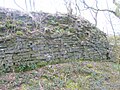
Views of Broadstone's industrial archaeology remains

Geilsland House and School

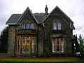
Geilsland House is part of Geilsland school, run by the Church of Scotland under its 'Crossreach' initiative. [10] The name is pronounced 'Jillsland' locally. The origin of the name may refer to a gil or gyll, referring to a cleft or ravine as found at the 'Fairy Glen' where the Powgree Burn cuts through the fields. Geilsland school, run by the Church of Scotland, is located nearby.
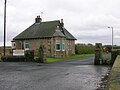
The Gunn family

Gilbert Gunn was a well known railway contractor from Gateside and, in the early years of the 20th-century, was said to be one of Scotland's strongest men. For a bet, he had once carried a cheese, a ham, and a lade of meal for nearly one mile (1.5 kilometres). [11] Gilbert and his wife Jane Speir were the parents of Mary Gunn who was the victim of an unsolved murder at Northbank Cottage near Portencross that took place in 1913.

See also

Netherhill old toll Netherhill near Gateside.JPG
Netherhill old toll

Related Research Articles

Beith is a small town in the Garnock Valley, North Ayrshire, Scotland approximately 20 miles south-west of Glasgow. The town is situated on the crest of a hill and was known originally as the "Hill o' Beith" after its Court Hill.

Hessilhead

Hessilhead is in Beith, North Ayrshire, Scotland. Hessilhead used to be called Hazlehead or Hasslehead. The lands were part of the Lordship of Giffen, and the Barony of Hessilhead, within the Baillerie of Cunninghame and the Parish of Beith. The castle was situated at grid reference NS380532.

Brackenhills railway station

Brackenhills railway station was a railway station approximately one mile south-west of the town of Beith, close to Barkip, North Ayrshire, Scotland, part of the Lanarkshire and Ayrshire Railway.

Barony and Castle of Giffen Barony in the former District of Cunninghame, now North Ayrshire

The Barony of Giffen and its associated 15th-century castle were in the parish of Beith in the former District of Cunninghame, now North Ayrshire. The site may be spelled Giffen or Giffin and lay within the Lordship of Giffin, which included the Baronies of Giffen, Trearne, Hessilhead, Broadstone, Roughwood and Ramshead; valued at £3,788 9s 10d. The Barony of Giffen comprised a number of properties, including Greenhills, Thirdpart, Drumbuie, Nettlehirst and Balgray, covering about half of the parish of Beith. Giffen was a hundred merk land, separated from the Barony of Beith, a forty-pound land, by the Powgree Burn which rises on Cuff hill. The Lugton Water or the Bungle Burn running through Burnhouse may have been the Giffen barony boundary with that of the adjacent barony and lands of Aiket castle.

Barrmill, North Ayrshire Small village in North Ayrshire, Scotland

Barrmill is a small village in North Ayrshire, Scotland about 1+12 miles east of Beith on the road to Burnhouse and Lugton. Locally it is known as the Barr.

Spiers School

Spier's School, at Beith, in North Ayrshire, Scotland was opened in 1888 and closed in 1972. The school, now demolished, was built using Ballochmyle red sandstone and was reminiscent of the ancient Glasgow University. The school motto was 'Quod verum tutum'. The gardens and woodlands are open to the public at all times.

Geilsland House

Geilsland House lies in between the village of Gateside and the town of Beith in North Ayrshire, Scotland. After serving as a private house it became a school and most recently (2015) has passed into the ownership of the Beith Development Community Trust.

Broadstone Castle Castle in Ayrshire, Scotland

Broadstone lies close to the small village of Gateside in North Ayrshire, Scotland about half a mile east of Beith in the old Barony of Giffen.

Hill of Beith Castle

The old Barony and castle, fortalice, or tower house of Hill of Beith lay in the feudal Regality of Kilwinning, within the Baillerie of Cunninghame, and the Sherrifdom of Ayr, now the Parish of Beith, North Ayrshire, Scotland.

Loch Brand

Loch Brand or Loch of Boghall was a loch situated in a depression between the Grange Estate, Crummock, Hill of Beith Castle site and Boghall in the Parish of Beith, North Ayrshire, Scotland. The loch was fed by the Grange Burn and surface runoff, such as from the old rig and furrows indicated by Roy's Maps of the mid 17th century. The loch was drained by the Boghall Burn that runs passed the 'Court Hill' and into Powgree Burn at Gateside.

Blae Loch (Beith) A lake in Ayrshire, Scotland

The Blae Loch is a small freshwater loch situated in a hollow in a low-lying area beneath Blaelochhead Hill in the Parish of Beith, North Ayrshire, Scotland.

Nettlehirst

Nettlehirst or Nettlehurst was a small mansion house (NS365504) and estate in the Parish of Beith, near Barrmill in North Ayrshire, Scotland. The house was built in 1844 and burned down in 1932.

Barkip Human settlement in Scotland

Barkip, also known as The Den, is a hamlet in North Ayrshire, Scotland about three miles southwest of Beith on the A737 road to Dalry. The earliest recorded name is 'Blairkip'. In the Gaelic language, the name Barkip comes from bar ("top"), and kip. It is not clear when or why the name 'The Den' started to be used although it appears in the local press as both in 1898, however in Scots as in old English one meaning is 'A hollow between hills,' which is certainly an accurate description of the geography of the area that Barkip lies in. Following construction of a new road, Barkip no longer sits on the main Beith to Dalry road.

Lands of Bogston

Bogston or later Bogstone was a small estate in the old Barony of Giffen near Barrmill in the Parish of Beith, North Ayrshire, once held by collateral descendants of the Montgomeries of Broadstone. The estate covered 160 acres or around 65 hectares, its rental in 1896 being £180 per annum.

Burnhouse Human settlement in Scotland

Burnhouse, sometimes known locally as The Trap from "Man Trap", is a small village or hamlet in North Ayrshire, Parish of Beith, Scotland. It lies on a crossroads of old B706 and the more recent A736 Lochlibo Road, between Lugton and Torranyard.

The Lands of Roughwood

Roughwood once Ruchwood is a farm, originally a estate, possessing at one time a small tower castle. Roughwood is situated near to the town of Beith in North Ayrshire, Scotland; the lands lay within the old Lordship of Giffen.

Greenhills, North Ayrshire Human settlement in Scotland

Greenhills is a small village or hamlet in North Ayrshire, Parish of Beith, Scotland. It lies between the settlements of Barrmill and hamlet of Burnhouse on a crossroads of the B706 and the lanes to Nettlehirst and Tandlehill via Thirdpart. It is named after the 'Green Hill' an artificial mound, a Moot, Law or Justice hill that once stood here. The settlement lay within the old Barony of Giffen; the castle no longer exists. The village lies within Barrmill and District Community Association's area and is also covered by Beith Community Council.

Lands of Willowyard

The ancient lands of Willowyard, Willieyeards, Williyard or Willizeards were part of the holdings of the Regality of Kilwinning, Barony of Beith, and Bailiary of Cuninghame. They later became the property of the Montgomerie family before being sold to the Simson family in 1723. The manor house still survives as part of a business premises and the nearby industrial estate and whisky bond carry the name 'Willowyards'.

Lands of Marshalland

The lands of Marshalland, Marsheland, Marsheyland or Marshyland were part of the holdings of the Barony of Beith, Regality of Kilwinning and Bailiary of Cuninghame. They became the property of the Lyle family, then the Shedden family, passing next to the Spier's family before finally becoming part of the Spier's Trust lands. The laird's house and farm were demolished in the 1960s.

Lands of Morishill

The lands of Morishill,Morrishill,Moorishill or Moricehill were part of the holdings of the Barony of Beith, Regality of Kilwinning and Bailiary of Cuninghame. The name may have derived from large shielings or huts that were once erected at the site.

References

  1. Johnston, J. B. (1903). Place-names of Scotland. Edinburgh : David Douglas. Page 248.
  2. "RCAHMS Canmore archaeology site". Archived from the original on 4 December 2008. Retrieved 6 September 2008.
  3. Smith, John (1895). Prehistoric Man in Ayrshire. Pub. Elliot Stock. P. 81.
  4. Arch & Hist Collections of relating to the counties of Ayr & Wigton. V. II. 1880. p. 28
  5. Smith, John (1895). Prehistoric Man in Ayrshire. London : Elliot Stock. p. 81
  6. RCAHMS Retrieved 2010-09-30
  7. Dobie, James D. (ed Dobie, J.S.) (1876). Cunninghame, Topographized by Timothy Pont 1604–1608, with continuations and illustrative notices. Glasgow: John Tweed. p. 95
  8. Blaeu's map Retrieved : 2010-12-11
  9. Complete Songs and Poems of Robert Tannahill. Centenary Edition. 1874. Tannahill Club. Paisley : William Wilson. Page iii.
  10. "Geilsland school". Archived from the original on 4 August 2008. Retrieved 30 September 2010.
  11. House, Jack (1984). Murder Not Proven. Glasgow : Richard Drew Publishing. ISBN   0-86267-065-9. Page 124