Brahmpur, Bihar

Last updated

Brahmpur
Village
Barhampur Temple.jpg
Barhampur block map.png
Map of Brahmapur in Brahmapur block
India Bihar location map.svg
Red pog.svg
Brahmpur
Location in Buxar, Bihar, India
Coordinates: 25°21′N84°11′E / 25.35°N 84.18°E / 25.35; 84.18
CountryFlag of India.svg India
State Bihar
District Buxar
Elevation
58 m (190 ft)
Population
 (2011)
  Total13,727
Languages
  Official Hindi
  Local Bhojpuri
Time zone UTC+5:30 (IST)
ISO 3166 code IN-BR
Website www.brahampurbuxar.com

Brahmpur is a large village and corresponding community development block in Buxar district of Bihar. [1] It is known for its temple of Shiva, its religious practices, and its cattle fair. People visit Brahmapur to perform religious rituals in the temple of Shiva.

Contents

As of 2011, the population of Brahmapur was 17,057, in 2,554 households, while the total population of the block was 196,070, in 28,826 households. [2]

Etymology

Brahmapur means "the place of Brahma" in Sanskrit. According to Hindu Itihas, the town was founded by Brahma, giving rise to the name Brahmapur ("Brahma" stands for Brahma and "pur" means place).

The inhabitants of Brahmapur speak the Bhojpuri dialect. In Bhojpuri, the city is sometimes referred to as Barahmpur.

History

In Medieval India, an Islamic invader from Afghanistan Ghaznavi came to destroy the temple and loot its wealth. The people of the village warned him that if he performed these violent acts, Shiva’s third eye would burn him to ashes. Ghaznavi told the people that no such god existed and if it existed, the entrance of the temple would change its direction from east to west. (Every temple of Lord Shankar had its door facing east.) He then informed them that if that were to occur, he would leave the temple untouched and would never return. The next morning, when Ghaznavi came to destroy the temple, he was surprised to see the entrance of the temple had changed from east to west. He left the temple as he had promised. [3]

Demographics

According to the 2011 Indian census, [4] Brahmapur had a population of approximately 13,727: 7,328 males and 6,399 females. The number of households in Brahmapur was 1,927.

Geography

Brahmapur is situated at 25°35'57"N 84°18'5"E [5] It is surrounded by many small villages such as Raghunathpur, Purwan, Nimej, Balua, Umedpur, Ramgarh, Garahtha, Gayghat. The landscape is very flat with no mountains.

Transportation

Brahmapur is not accessible directly by train. Instead, visitors must stop at the nearest railway station in Raghunathpur, which is 3 km from Brahmapur. It can be directly reached by roadways connected with the NH 84, which goes through Brahmapur. [6]

Hospitals

Brahmapur's government-allocated Primary Health Care Center [7] is located at Raghunathpur, but there are also private hospitals in Brahmapur.

Education

Brahmeshwar Nath High School provides education from grades six to twelfth and one girls college. In addition, there are two government primary schools, three upper middle schools [8] and around three private schools such as P.L public school (C.B.S.E pattern, class:- Nursery to 10) and paramount children academy (nearest brahampur police station and shiv mandir) in Brahmapur. For higher studies, students go to Dumraon, Buxar, Ara or other places.

Tourism

Brahmapur is a center of religious tourism. Many people from the Arrah (Bhojpur) District, Buxar district, Ballia District and Chhapra District come to worship Lord Shiva or to get married in the temple. The people of Brahmapur organize a cattle fair, where farmers come from Bihar and Uttar Pradesh to purchase cattle for breeding and herding. The Falguni cattle fair is very famous in Bihar and Uttar Pradesh, and takes place in the Hindu month of Falgun. Horses, elephants and camels are also bought and sold at the fair. October to June is the best time for tours to Brahmapur. However, tours to Brahmapur during the festivals celebrated in the district can also be arranged. The main festivals of the region include Car Festival, Dusshera, Taratarini Festival, Thakurani Yatra, Buda and Khambeshwari Yatra

Economy

The people of Brahmapur depend primarily on agriculture and, to a lesser extent, tourism. Recently, inhabitants have begun to leave Brahmapur in the same manner as the rest of rural Bihar, in an effort to find better work opportunities elsewhere. And there are two cinema hall and one AC cinema hall, five malls, four bike showrooms and maruti show room, five banks available.

Languages

The most commonly spoken language in Brahmapur is Bhojpuri. People also speak Hindi, Urdu, and English, to some extent.

Villages

Brahmapur block contains 104 villages, of which 65 are inhabited and 39 are uninhabited. [2]

Village nameTotal land area (hectares)Population (in 2011)
Dhaf Chapra (Unsurveyed)00
Pandepur Path (Unsurveyed)00
NainijorDiaraPachhimTurkau00
Baghaunch (Unsurveyed)00
Dundh Chapra (Unsurveyed)00
Pokhra (Unsurveyed)00
Nainijor Diara Pachhim (Unsurveyed)00
Mahaur Naubara00
Sapahi (Unsurveyed)00
Manipur (Unsurveyed)00
Kisagar214338
Ranipur2090
Garhatha Khurd1581,358
Ramgarh57728
Nimej 350.86,482
Garhatha Kalan 68.31,503
Bojhwalia961,823
Jogia 2043,322
Gayghat 3508,633
Nandpur50559
Balua 1143,193
Chaube Chak15.4785
Bairia 96.34,007
Panrepur891,866
Udhaura 2704,101
Parnahi25.9369
Dallupur12.6199
Chakani314.4963
Ekdar181.8175
Milki Bisupur00
Bisupur00
Bahduri370
Nainijor 973.325,004
Mahuar 3596,421
Chandarpura 208.45,259
Harnathpur 68.42,060
Hathilpur 122.22,063
Kapurpur73.3947
Jaipur30350
Umedpur 91.92,407
Dhadha1170
Kathia33.21,779
Dubauli93.41,635
Kuawan170673
Maharajganj59.4437
Karanpura164.10
Arjunpur770
Basudharpah57.10
Rupah340
Bhojwalia360
Gahauna 623,176
Dekuli84.60
Dhan Chhapra53809
Purwa 98.72,215
Dhebani56.7249
Brahmapur(Block headquarters)906.917,057
Kant 643.96,004
Madhukara152.20
Menhmarara158.60
Baswar150.91,789
Pakrahi66.8187
Rajpur3611,721
Raghunathpur 563.811,857
Dhorhanpura91.4688
Bharkhar134.41,242
Adharpa429.81,268
Rahthua 5932,108
Kaithi 9186,800
Dharauli 431.43,444
Babhani61.10
Khochariyawan 1492,047
Pahari Chak27.9331
Bhadsari280.41965
Ghanshampur59353
Sukalpura23.1235
Palatpura44.9115
Ekrasi 885.85,100
Pokharhan 663.34,350
Piprarh106.81,009
Akorhi159.4938
Baruhan 443.93,267
Kurthiya1191,602
Atrauliya300
Bagen 9335,291
Bhada 379.24,564
Bararhi 5055,374
Churamanpur720
Bhadwar 922.75,318
Ramdiha117.4990
Kodai1371,239
Choubey Bala Gangbarar370
Gaighat (Part)197.40
Rudrapur242.90
Chak Pheralal210
Chulhan Chak48.60
Pirthi Chapra (Part)31.90
Baghi78.60
Dangrabad133.10
Ghinhu Chapra (Sukul Chapra)47.60
Ghinhu Chapra40.60
Chak Durjanpur83.20
Jug Chapra1310
Maji Karanpur00

See also

Related Research Articles

<span class="mw-page-title-main">Deoghar</span> City in Jharkhand, India

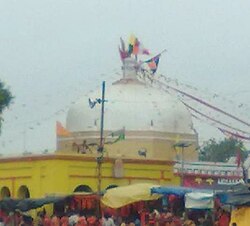
Deoghar is a major city in Jharkhand, eastern India. It is a holy place of Hinduism. The city is primarily known for Baidyanath Temple, one of the 12 Jyotirlingas of Shiva, one of the principal deities in Hinduism. The sacred temples of the city make this a place for pilgrimage and tourists. The city is very sacred to the followers of Hinduism.

<span class="mw-page-title-main">Buxar district</span> District of Bihar in India

Buxar district is one of the 38 districts of Bihar, India. Located in the southwestern part of the state, it is a primarily agricultural district. The district headquarters is at the town of Buxar. Buxar district was carved out from Bhojpur district on 17 March 1991.

<span class="mw-page-title-main">Arrah</span> City in Bihar, India

Arrah is a city and a municipal corporation in Bhojpur district in the Indian state of Bihar. It is the headquarters of Bhojpur district, located near the confluence of the Ganges and Sone rivers, some 24 mi (39 km) from Danapur and 36 mi (58 km) from Patna.

<span class="mw-page-title-main">Kaimur district</span> District of Bihar in India

Kaimur district is one of the 38 districts of Bihar, India. The district headquarters are at Bhabua. Before 1991, it was part of Rohtas District. Till 1764 the region was a part of Ghazipur District and was a part of Kamsaar Raj and later it was a part of Chainpur Estate till 1837.

<span class="mw-page-title-main">Bhanjanagar</span> Town in Odisha, India

Bhanjanagar is a town and Municipality in Ganjam district in the state of Odisha, India.

<span class="mw-page-title-main">Surada</span> Town in Odisha, India

Surada is a town and a Notified Area Council in Ganjam district in the Indian state of Odisha.

<span class="mw-page-title-main">Buxar</span> City in Bihar, India

Buxar is a nagar parishad city in the state of Bihar, India, sharing border with Balia and Ghazipur district of Uttar Pradesh. It is the headquarters of the eponymous Buxar district, as well as the headquarters of the community development block of Buxar, which also contains the census town of Sarimpur along with 132 rural villages.

<span class="mw-page-title-main">Jyotiba Temple</span> Pilgrimage site in Maharashtra, India

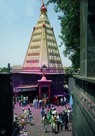
Jyotiba Temple is a holy site of Hinduism near Wadi Ratnagiri in Kolhapur district of Maharashtra state in western India. The deity of the temple is known by the same name. An annual fair takes place on the full moon night of the Hindu months of Chaitra and Vaishakha.

<span class="mw-page-title-main">Tilouthu</span> Town in Bihar, India

Tilothu, also spelled Tilauthu or Tilothu, is a village and corresponding community development block in Rohtas district, Bihar, India. It is located 15 km from Dehri-on-Sone on the west bank of the Son River. As of 2011, the population of Tilouthu was 16,402, in 2,745 families, while the corresponding block population was 109,249.

<span class="mw-page-title-main">Bhojpur district, India</span> District of Bihar in India

Bhojpur district is one of the 38 districts of the Indian state of Bihar. Arrah city is the administrative headquarters of this district. Bhojpur district came into existence in 1972. Earlier it was the part of Shahabad district. This district is named "Bhojpur" after great Parmara King Bhoja as most early settlers were Rajput rulers of Parmara dynasty then called as Ujjainiya.

Bandhaguda is a village under "Sheragada" block in Ganjam district, Odisha, India. It is also a "Grama Panchayat" consists of six villages which are B.Chikili, Bandhaguda, Chasamahuli, Gopapalli, Laxminursinghapur and Sadangipalli. It is 55 km from the Brahmapur city. Historically this village provides rural education to around 15 villages around the area. People get their primary education from Janata Uchha Prathamika Bidyalaya and secondary education is being provided by Sri Jagannath Vidyapeeth, Kansa.

<span class="mw-page-title-main">Bhojpuri region</span> Region in India

Bhojpur is a ethnolinguistic and cultural area in the Indian subcontinent where the Bhojpuri language is spoken as a mother tongue. The Bhojpuri region encompasses parts of the Indian states of Bihar, Uttar Pradesh, and Jharkhand, and the Madhesh, Gandaki and Lumbini provinces of Nepal.

Semra is a hamlet in Buxar district of Bihar state, India. It is part of the larger village of Garhatha Kalan, which in turn lies within the Brahampur block. The village is surrounded by river Ganga from three sides. Bhojpuri is the native language of Semra. Arahar dal and usina chawal are major products of the region.

<span class="mw-page-title-main">Brahampur Assembly constituency</span> Constituency of the Bihar legislative assembly in India

Brahampur Assembly Constituency is an assembly Legislative constituency in Buxar district in the Indian state of Bihar. It is a part of the Buxar Lok Sabha (parliamentary) constituency of the state. As recommended by the Delimitation Commission of India in 2008, the Brahampur legislative assembly segment comprises Simri, Chakki and Brahampur community development blocks.

Chandrapura is a census village in Buxar district in the Indian state of Bihar. It is situated near banks of the Ganga river Nanijor. Chandrapura is a village located in Brahmpur block. It has a total of 766 families residing in it and a population of 5259 people as per government records.

Makarajhola is a village and a Gram panchayat in Ganjam district in the Indian state of Odisha.

Bakulari is a village located in Sohagara Panchayat of Guthani Block of Siwan district in the Indian state of Bihar.

Rajpur is a large village located in Raghunathpur Block in Siwan district in Bihar. It belongs to Saran Division. It is located 28 km towards South from District headquarters Siwan. 3 km from RaghunathPur. 114 km from State capital Patna. Rajpur Pin code is 841504 and postal head office is Raghunathpur (Siwan). As per the administration register, the village code of Rajpur is 232505. The village has 604 homes. This Place is in the border of the Siwan District and Ballia District. Ballia District Maniar is west towards this place. It is near to the Uttar Pradesh State Border.

Chhatanwar is a village located in Dumraon block in Buxar district of Bihar state. It is situated in the western region of the Bihar state of India. Bhojpuri is the language spoken in the village. It is situated 6 km from sub-district headquarter Dumraon and 24 km from district headquarter Buxar. As per 2009 stats, Chhatanwar village is also a gram panchayat.

<span class="mw-page-title-main">Basuki Bihari</span> Village in Bihar, Madhubani

Basuki Bihari is a big village in the Madhubani district in State of Bihar, India. According to India Population Census 2011 the population of the village is 14385. The majority of people of this village speak in Maithili language. The total area of the village is 13.62 km2. The village is divided into two Gram Panchayat Basuki Bihari North and Basuki Bihari South. The head of the Gram Panchayat is called as Mukhiya. Mukhiya is elected by adult people of the village. The election of Mukhiya is held by the Election Commission of Bihar state. This village is known for social cultural activities like Durga Puja, Chhath, Kali Puja and Sarswati Puja. The village is connected by State Highway No 75 from Darbhanga to Madhwapur. This village is only two kilometres far from the Indo-Nepal Border at Madhwapur in Madhubani district.

References

  1. "About Brahmapur Block". Archived from the original on 2 December 2013. Retrieved 13 May 2013.
  2. 1 2 "Census of India 2011: Bihar District Census Handbook - Buxar, Part A (Village and Town Directory)". Census 2011 India. pp. 19–20, 23–98, 254–309, 681–82, 730–746. Retrieved 3 July 2020.
  3. "History of Brahmeshwar Nath Temple". Bihari By Nature. 20 June 2017.
  4. "Census of Brahmapur". Census of India 2011. Govt. of India. Archived from the original on 13 May 2013. Retrieved 13 May 2013.
  5. "Co-ordinates of Brahmapur". wikimapia.org. Retrieved 13 May 2013.
  6. "National Highway No. 84". Wikimapia. Retrieved 13 May 2013.
  7. "Hospitals in Brahmapur" (PDF). Govt. of Bihar. Retrieved 13 May 2013.[ permanent dead link ]
  8. "Schools in Brahmapur" (PDF). Govt. of Bihar. Retrieved 13 May 2013.[ permanent dead link ]