Brandenkopf

Last updated
Brandenkopf

Brandenkopf 2015.jpg

The Brandenkopf seen from the south
Highest point
Elevation 945 m (3,100 ft)
Coordinates 48°20′19″N08°09′13″E / 48.33861°N 8.15361°E / 48.33861; 8.15361 Coordinates: 48°20′19″N08°09′13″E / 48.33861°N 8.15361°E / 48.33861; 8.15361
Geography
Location Baden-Württemberg, Germany

The Brandenkopf is 945.2 m above  sea level (NHN) [1] and one of the highest mountains in the Central Black Forest in southern Germany. The mountain lies in the county of Ortenaukreis in the state of Baden-Württemberg within the municipalities of Oberharmersbach, Fischerbach and Hausach, its summit is part of Oberharmersbach. The mountain forms the prominent centrepiece between the valleys of the Kinzig, the Wolf and the Harmersbach.

<i>Normalhöhennull</i> standard reference level, the equivalent of sea level, used in Germany to measure height

Normalhöhennull or NHN is a vertical datum used in Germany.

Mountain A large landform that rises fairly steeply above the surrounding land over a limited area

A mountain is a large landform that rises above the surrounding land in a limited area, usually in the form of a peak. A mountain is generally steeper than a hill. Mountains are formed through tectonic forces or volcanism. These forces can locally raise the surface of the earth. Mountains erode slowly through the action of rivers, weather conditions, and glaciers. A few mountains are isolated summits, but most occur in huge mountain ranges.

Central Black Forest

The Central Black Forest, also called the Middle Black Forest, is a natural or cultural division that generally refers to a region of deeply incised valleys from the Rench valley and southern foothills of the Kniebis in the north to the area of Freiburg im Breisgau and Donaueschingen in the south. Its highest area, which is southeast of the Elz valley, is also part of the High Black Forest.

Contents

The name of the Brandenkopf ("Fire Peak") is derived from a great forest fire in 1730. Before this event it was called the Varnlehenskopf.

The Brandenkopf is well developed with roads and footpaths (including the Hansjakobweg II and a link to the West Way, 3.5 km away) from several directions.

There is a transmitter, the Sender Brandenkopf, on the mountain.

Sights

The Brandenkopf Tower Oberharmersbach Brandenkopfturm.jpg
The Brandenkopf Tower

The 32-metre-high [2] Brandenkopf Tower (Brandenkopfturm) has stood on the summit since 1929. This is a stone observation tower, which has extensive views over the Black Forest countryside and, on clear days, as far as the Alps, Vosges and Swabian Jura. Before the stone tower was built there had been wooden predecessor structures.

Observation tower structure used to view events from a long distance

An observation tower is a structure used to view events from a long distance and to create a full 360 degree range of vision to conduct the long distance observations. They are usually at least 20 metres (65.6 ft) tall and made from stone, iron, and wood. Many modern towers are also used as TV towers, restaurants, or churches. The towers first appeared in Germany at the end of the 18th century, and their numbers steadily increased, especially after the invention of the lift.

Black Forest mountain range in Baden-Württemberg, southwestern Germany

The Black Forest is a large forested mountain range in the state of Baden-Württemberg in southwest Germany. It is bounded by the Rhine valley to the west and south. Its highest peak is the Feldberg with an elevation of 1,493 metres (4,898 ft). The region is roughly oblong in shape with a length of 160 km (99 mi) and breadth of up to 50 km (31 mi).

Alps major mountain range system in Central Europe

The Alps are the highest and most extensive mountain range system that lies entirely in Europe, separating Southern from Central and Western Europe and stretching approximately 1,200 kilometres (750 mi) across eight Alpine countries : France, Switzerland, Italy, Monaco, Liechtenstein, Austria, Germany, and Slovenia. The mountains were formed over tens of millions of years as the African and Eurasian tectonic plates collided. Extreme shortening caused by the event resulted in marine sedimentary rocks rising by thrusting and folding into high mountain peaks such as Mont Blanc and the Matterhorn. Mont Blanc spans the French–Italian border, and at 4,810 m (15,781 ft) is the highest mountain in the Alps. The Alpine region area contains about a hundred peaks higher than 4,000 metres (13,000 ft).

The Black Forest Club maintains a hiking home and attached café on the Brandenkopf. The favourable location of the mountain, with its average wind speed oft 5.8 m/s at a height of 10 metres is exploited by a wind turbine.

Wind turbine device that converts wind energy into mechanical and electric energy

A wind turbine, or alternatively referred to as a wind energy converter, is a device that converts the wind's kinetic energy into electrical energy.

In summer 2002 a second wind turbine, the Bürgerwindrad Brandenkopf, was opened about 350 metres west of the hiking home. This turbine, an Enercon E-58, which has a hub height of 70 metres (100 metres total height) generating a nominal 1000 kW, produces an average of 2,000,000 kWh of electrical power per year. [3] and is thus one of the best sites in Germany in its performance class. In 2006 over 2,300 hours at full load were achieved. [4]

Related Research Articles

Feldberg (Black Forest) Mountain in the Black Forest, Baden-Württemberg, Germany

At 1,493 metres (4,898 ft) the Feldberg in the Black Forest is the highest mountain in Baden-Württemberg, and the highest in Germany outside of the Alps. The local municipality of Feldberg was named after the mountain.

Hornisgrinde mountain

The Hornisgrinde, 1,164 m (3,820 ft), is the highest mountain in the Northern Black Forest of Germany. The Hornisgrinde lies in northern Ortenaukreis district.

Schömberg, Calw Place in Baden-Württemberg, Germany

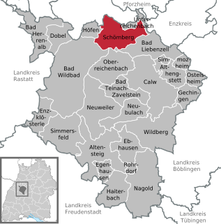
Schömberg is a spa town in the north of the Black Forest in Baden-Württemberg.

Heroldstatt Place in Baden-Württemberg, Germany

Heroldstatt is a village in the district of Alb-Donau in Baden-Württemberg in Germany.

Lemberg (Swabian Jura) mountain in Baden-Württemberg, Germany

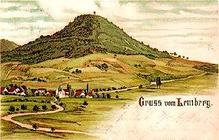
The Lemberg is a mountain located in the Tuttlingen district of Baden-Württemberg, Germany. The mountain is the highest point of the Swabian Jura. It is one of the "Ten Thousanders" —ten 1,000-metre-high summits of the region. On the peak of the mountain is a 30-m-high tower which, reaching above the surrounding trees, offers a beautiful prospect, in clear weather as far as the Alps.

Blauen (Badenweiler) mountain of the Black Forest, Germany

Blauen or Hochblauen is a 1,165-metre-high (3,820 ft) mountain in the southern Black Forest. The peak lies within the municipalities of Schliengen and Malsburg-Marzell in Landkreis Lörrach and the community of Badenweiler in LandkreisBreisgau-Hochschwarzwald. It is an ideal viewpoint with views of the Black Forest, Vosges, Jura Mountains, and the Alps.

Belchen (Black Forest) Mountain in the Black Forest, Germany

The Belchen, 1,414 metres (4,639 ft), or Black Forest Belchen is the fourth highest summit of the Black Forest after the Feldberg, Seebuck and the Herzogenhorn. The municipalities of Münstertal, Schönenberg and Kleines Wiesental meet on the summit dome of the Belchen which is located in the southwest German state of Baden-Württemberg.

Badener Höhe mountain

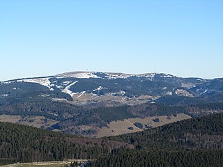
The Badener Höhe is a mountain in the Northern Black Forest in the German state of Baden-Württemberg. It lies within the borough of Baden-Baden and municipality of Forbach. With a height of 1,002.5 m above sea level (NHN), it is the highest point in the borough of Baden-Baden.

Fremersberg mountain

The Fremersberg is a hill, 524.6 m above sea level (NHN), on the western edge of the northern Black Forest in south Germany on the territory of the town of Baden-Baden and the municipality of Sinzheim. On the summit plateau, which is made of bunter sandstone there is the residential area of Fremersberg Turm with rented inn, which was built by the town of Baden-Baden in 1884, and the 85-metre-high Fremersberg Tower, built in 1961, a transmission tower with an observation platform.

Hochkopf (Southern Black Forest) mountain

The Hochkopf is a wooded ridge north of the village of Todtmoos in the southern part of the High Black Forest. At 1,263.4 m above sea level (NHN) its summit is one of the 20 highest points in the German state of Baden-Württemberg.

Merkur (mountain) mountain in Germany

The Merkur or Großer Staufenberg is a mountain, 668.3 m above sea level (NHN), in the Northern Black Forest, Baden-Württemberg, Germany. It is the Hausberg of Baden-Baden and located between the spa town and the town of Gernsbach.

Rohrhardsberg mountain

The Rohrhardsberg is a mountain in the Central Black Forest in southern Germany. At 1,152.1 metres (3,780 ft) above sea level, it is the northernmost summit of the elongated, north-south oriented Farnberg Plateau that has several high points over 1,150 metres. The mountain is situated near Elzach in the state of Baden-Württemberg.

Römerstein (mountain) mountain

Römerstein is a mountain of Baden-Württemberg, Germany. It lies on a plateau, whose highest point is 872 metres (2,861 ft) above sea level.

Roßkopf (Breisgau) mountain

Roßkopf (Breisgau) is a mountain of Baden-Württemberg, Germany.

Seebuck mountain

At a height of 1,448.2 m above sea level (NHN) the Seebuck is the second highest mountain the Black Forest after the Feldberg It is located in the German state of Baden-Württemberg.

Teufelsmühle (Black Forest) mountain in Germany

The Teufelsmühle is a mountain south of Loffenau in the Northern Black Forest. It lies between the valleys of the Murg in the west and the Alb in the east. The Alb rises near the eastern flank of the mountain, before reaching Bad Herrenalb a few kilometres further north. Over the summit plateau of the Teufelsmühle, which runs in a north-south direction, runs the boundary between the municipalities of Gernsbach in the Murg valley and Loffenau, both of which belong to the Baden-Württemberg county of Rastatt.

Hohloh mountain

The Hohloh is a mountain, 988.3 m above sea level (NHN), on the eastern main ridge of the Northern Black Forest in Germany. It lies near the village of Kaltenbronn in the borough of Gernsbach, a town in the county of Rastatt in the German state of Baden-Württemberg. Its summit is the highest point in the borough of Gernsbach and the eastern chain of the Northern Black Forest, the ridge between the rivers Murg and Enz. A mountain pass runs northeast of the summit plateau between the two river valleys passing over the saddle of Schwarzmiss.

Mahlberg (mountain) mountain

The Mahlberg is a mountain in the northwest of the Northern Black Forest and, at 612.5 m above sea level (NHN), is the highest point in the Baden-Württemberg county of Karlsruhe and the parish of Völkersbach. Its eastern side belongs to the municipality of Malsch in Karlsruhe and the western side to the borougy of Gaggenau in the county of Rastatt.

Jericho Mountain

Jericho Mountain, also known locally as Black Mountain, is a mountain in Coös County, New Hampshire, in the United States. It has an elevation of 2,454 feet (748 m).

References

  1. Map services of the Federal Agency for Nature Conservation
  2. Brandenkopfturm at Mein Urlaub in Deutschland
  3. Homepage Bürgerwindrad Brandenkopf. Accessed 3 September 2014.
  4. Windkraft in Baden-Württemberg. Internet page of the Federal Wind Power Association. Retrieved 3 September 2014.