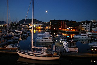
Florø (help·info) is a town and the administrative centre of Flora Municipality in Sogn og Fjordane county, Norway. The town was founded by royal decree in 1860 as a ladested on the island of Florelandet, located between the Botnafjorden and Solheimsfjorden. Florø is Norway's westernmost town—west of Amsterdam, Brussels, and Nice. It is the most western town on the mainland in the Nordic countries.

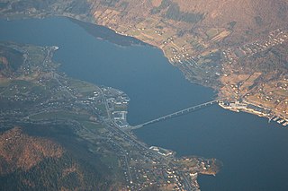
Årdalstangen is the administrative centre of the municipality Årdal in Sogn og Fjordane county, Norway. The village is one of the two main population centers in the municipality, along with the village of Øvre Årdal. The 1.08-square-kilometre (270-acre) village has a population (2013) of 1,489; giving the village a population density of 1,379 inhabitants per square kilometre (3,570/sq mi).

Verdalsøra is a town in the municipality of Verdal in Trøndelag county, Norway. The town is the administrative center of the municipality. It is located along the Trondheimsfjord at the mouth of the river Verdalselva. The village of Vinne lies 4 kilometres (2.5 mi) to the southeast, Trones lies about 5 kilometres (3.1 mi) to the north, the villages of Forbregd/Lein lie about 4 kilometres (2.5 mi) to the northeast, and the village of Stiklestad lies about 3 kilometres (1.9 mi) to the east. In 1998, the municipal council of Verdal voted to grant the urban area of Verdalsøra town status under the laws of Norway.

Nordkjosbotn (Norwegian) or Gárgán (Northern Sami) is a small village in Balsfjord Municipality in Troms county, Norway. The village lies about 70 kilometres (43 mi) southeast of the city of Tromsø. Two major highways, European route E6 and European route E8, meet in this village, making it a major crossroads in Northern Norway, with an estimated annual passage of 3 million people. The 0.7-square-kilometre (170-acre) village has a population (2017) of 464 which gives the village a population density of 663 inhabitants per square kilometre (1,720/sq mi). Nordkjosbotn Church is located in this village. Macks Ølbryggeri, a brewery, has been operating in Nordkjosbotn since 2012.
Ikornnes is a village in Sykkylven Municipality in Møre og Romsdal county, Norway. It is located along the Sykkylvsfjorden, about 4 kilometres (2.5 mi) east of Tusvik, 7 kilometres (4.3 mi) north of Straumgjerde, and about 3 kilometres (1.9 mi) west of the municipal center of Aure via the Sykkylven Bridge.

Myklebost or Myklebust is a village in Ålesund Municipality in Møre og Romsdal county, Norway. It is located on the south side of the island of Ellingsøya, about 4 kilometres (2.5 mi) west of the village of Årset and about 5 kilometres (3.1 mi) east of the village of Hoffland. Myklebost is about 10 kilometres (6.2 mi) northeast of the city center of Ålesund.

Grov is a small village in the municipality of Flora in Sogn og Fjordane county, Norway. Grov lies along the Eikefjorden at the junction of the highways Rv.5 and Fv.614, just a couple kilometres south of the Norddalsfjord Bridge. Grov is about 10 kilometres (6.2 mi) east of the village of Brandsøy and 15 kilometres (9.3 mi) east of the town of Florø along Rv.5, and about 8 kilometres (5.0 mi) to the west is the village of Eikefjord. The Tonheim-Grov area had 100 inhabitants in 2001.
Austreim is a village in the municipality of Høyanger in Sogn og Fjordane county, Norway. The village is located on the north shore of the Sognefjorden, about 10 kilometres (6.2 mi) southwest of the municipal center of Høyanger, about 2.5 kilometres (1.6 mi) east of the village of Kyrkjebø, and about 12.5 kilometres (7.8 mi) southeast of the village of Vadheim where there is access to the European route E39 highway. The 0.37-square-kilometre (91-acre) village has a population (2013) of 359, giving the village a population density of 970 inhabitants per square kilometre (2,500/sq mi).

Sogndalsfjøra is the administrative center of the municipality of Sogndal in Sogn og Fjordane county, Norway. It is located where the river Sogndalselvi runs out in the Sogndalsfjorden, a branch of the large Sognefjorden. The village is located about 3.5 kilometres (2.2 mi) northwest of the village of Kjørnes, about 10 kilometres (6.2 mi) northwest of the village of Kaupanger, and about 31 kilometres (19 mi) southeast of the village of Fjærland.

Sande is the administrative centre of the municipality of Gaular in Sogn og Fjordane county, Norway. The village is located along the Gaula River, about 10 kilometres (6.2 mi) from where the river meets the Dalsfjorden. The 0.59-square-kilometre (150-acre) village has a population (2013) of 745, giving the village a population density of 1,263 inhabitants per square kilometre (3,270/sq mi). Sande Church is located in this village, serving the people of the central part of the municipality.
Andorsjøen (Norwegian) or Aantesjaevrie (Southern Sami) is a lake in the municipality of Snåsa in Trøndelag county, Norway. It lies about 25 kilometres (16 mi) east of the village of Snåsa. The Blåfjella–Skjækerfjella National Park borders the 4.25-square-kilometre (1.64 sq mi) lake to the south and east. The lake Store Øyingen lies about 10 kilometres (6.2 mi) to the southwest.

Holvik or Holvika is a small village on the south side of the island of Vågsøy in Vågsøy Municipality in Sogn og Fjordane county, Norway. It is situated along the Vågsfjorden, a part of the large Nordfjorden. The village is located about 3 kilometres (1.9 mi) southwest of the town of Måløy and about 2.5 kilometres (1.6 mi) east of the village of Vågsvåg.
Nyttingnes is a hamlet with 28 inhabitants and 9 houses in the municipality of Flora in Sogn og Fjordane county, Norway. Nyttingnes is located 6 kilometres (3.7 mi) northwest of the village of Steinhovden and about 3 kilometres (1.9 mi) across the fjord from the village of Brandsøy. The town of Florø lies about 8 kilometres (5.0 mi) to the west, although the road from Nyttingnes to Florø goes around the fjord via the village of Eikefjord. In recent history, there has been a negative demographic trend in this village. Nyttingnes is made up of the farms: Tunet, Bakken, Pergarden, Ludviggarden, Kvia, Opptun and Rabbane. Historically, the inhabitants were farmers and fishermen. The nearby Skårafjæra beach area is popular for many tourists.

Søfteland or Syfteland is a village in Os municipality in Hordaland county, Norway. It lies on the Bergen Peninsula, along the European route E39 highway, about 6 kilometres (3.7 mi) north of the municipal centre of Osøyro and about 20 kilometres (12 mi) south of the city of Bergen. The mountain Møsnuken lies about 3.5 kilometres (2.2 mi) east of the village and the mountain Lyshornet lies about 2.3 kilometres (1.4 mi) west of the village. The 0.94-square-kilometre (230-acre) village has a population (2013) of 1425, giving the village a population density of 1,516 inhabitants per square kilometre (3,930/sq mi).
Olden is a village and urban area in the municipality of Stryn in Sogn og Fjordane county, Norway. Olden is located at the mouth of the Oldeelva river at the northern end of the Oldedalen valley on the southern shore of the Nordfjorden. The 0.57-square-kilometre (140-acre) village has a population (2013) of 498, giving the village a population density of 874 inhabitants per square kilometre (2,260/sq mi). Olden is located about 6 kilometres (3.7 mi) southwest of the village of Loen, about a 16 kilometres (9.9 mi) drive southeast of the municipal center of Stryn, and about 15 kilometres (9.3 mi) east of the village of Innvik.
Kleive is a village in Molde Municipality in Møre og Romsdal county, Norway. It is located at the end of the Fannefjorden, about 25 kilometres (16 mi) east of the city of Molde and about 7 kilometres (4.3 mi) east of the village of Hjelset. Kleive Church is located in the village. The 0.78-square-kilometre (190-acre) village has a population (2012) of 493, which gives the village a population density of 632 inhabitants per square kilometre (1,640/sq mi).
Hjelset is a village in Molde Municipality in Møre og Romsdal county, Norway. It is located on the north shore of the Fannefjorden, about 8 kilometres (5.0 mi) west of Kleive and about 16 kilometres (9.9 mi) east of the town of Molde. The European route E39 highway runs through the village on its way northeast from the town of Molde to Batnfjordsøra in Gjemnes Municipality. The 0.86-square-kilometre (210-acre) village has a population (2013) of 1,037 which gives the village a population density of 1,206 inhabitants per square kilometre (3,120/sq mi).
Årset is a village in Ålesund Municipality in Møre og Romsdal county, Norway. The village is located along the Ellingsøyfjorden on the southern shore of the island of Ellingsøya, about 4 kilometres (2.5 mi) east of the village of Myklebost and about 12 kilometres (7.5 mi) west of the village of Tennfjord in Haram Municipality.

Volda is the administrative centre of Volda Municipality in Møre og Romsdal county, Norway. The village is located on the northeastern shore of the Voldsfjorden, just less than 10 kilometres (6.2 mi) south of the village of Ørsta. The 3.6-square-kilometre (890-acre) village has a population (2013) of 6,114; giving the village a population density of 1,698 inhabitants per square kilometre (4,400/sq mi).
Lindås is a village in Lindås municipality in Hordaland county, Norway. The village is located on the Lindås peninsula, about 25 kilometres (16 mi) north of the village of Knarvik and about 10 kilometres (6.2 mi) southeast of the Mongstad industrial area. The village of Hundvin lies about 8 kilometres (5.0 mi) southeast of Lindås.


