Burlington is a city in the Regional Municipality of Halton at the northwestern end of Lake Ontario in Ontario, Canada. Along with Milton to the north, it forms the western end of the Greater Toronto Area and is also part of the Hamilton metropolitan census area.

Harbourfront is a neighbourhood on the northern shore of Lake Ontario within the downtown core of the city of Toronto, Ontario, Canada. Part of the Toronto waterfront, Harbourfront extends from Bathurst Street in the west, along Queens Quay, with its ill-defined eastern boundary being either Yonge Street or York Street. Its northern boundary is the Gardiner Expressway. Much of the district was former water lots filled in during the early 1900s to create a larger harbour district. After shipping patterns changed and the use of the Toronto harbour declined, the area was converted from industrial uses to a mixed-use district that is mostly residential and leisure.

The Toronto waterfront is the lakeshore of Lake Ontario in the city of Toronto, Ontario, Canada. It spans 46 kilometres between the mouth of Etobicoke Creek in the west and the Rouge River in the east.
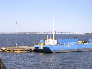
Hamilton Harbour, formerly known as Burlington Bay, lies on the western tip of Lake Ontario, bounded on the northwest by the City of Burlington, on the south by the City of Hamilton, and on the east by Hamilton Beach and Burlington Beach. It is joined to Cootes Paradise by a narrow channel formerly excavated for the Desjardins Canal. Within Hamilton itself, it is referred to as "Hamilton Harbour", "The Harbour" and "The Bay". The bay is naturally separated from Lake Ontario by a sand bar. The opening in the north end was filled in and channel cut in the middle for ships to pass. The Port of Hamilton is on the Hamilton side of the harbour.

The Scarborough Bluffs, also known as The Bluffs, is an escarpment in the Scarborough district of Toronto, Ontario, Canada. There are nine parks along the bluffs, with Bluffers Park being the only one with a beach. Forming much of the eastern portion of Toronto's waterfront, the Scarborough Bluffs stands above the shoreline of Lake Ontario. At its highest point, the escarpment rises 90 metres (300 ft) above the coastline and spans a length of 15 kilometres (9.3 mi).
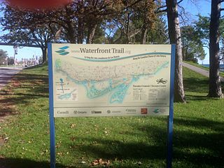
Stretching over 3600 km from Prince Township, west of Sault Ste. Marie, to the Quebec border, the Great Lakes Waterfront Trail is a signed route of interconnecting roads and off-road trails joining over 150 communities and First Nations along the Canadian shores of the Great Lakes and St. Lawrence River. A celebration of nature and culture, the Great Lakes Waterfront Trail is part of a strategy to protect and connect people to the largest group of freshwater lakes on earth. It is a legacy project of the Waterfront Regeneration Trust, a charity, and its community partners. Through Toronto, the trail is called the Martin Goodman Trail. The Waterfront Trail is also used by commuters in parts of Southern Ontario.

The Sound of Music Festival is an annual music festival in Burlington, Ontario, Canada. It is held in mid-June and usually falls on the Father's Day weekend.

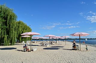
Spencer Smith Park is a park in downtown Burlington, Ontario located on the shore of Lake Ontario. It was named in memory of Spencer Smith, a former president of the Burlington Horticultural Society who was instrumental in the development of the park system throughout the city. It is home to the Sound of Music Festival, Canada's Largest Ribfest and the Burlington Beer Festival. It has a small beach and plenty of walking paths along Lake Ontario.

The Inner Harbor is a former industrial quarter of Syracuse, New York, situated at the center of a larger district long colloquially known as Oil City, and since 1989 rebranded as the Lakefront. The waterfront zone was originally considered to be limited to just that area bounded by West Kirkpatrick, Solar, West Bear, and Van Rensselaer streets, but it has been gradually enlarged by the process of familiarity and promotion to include the opposite sides of some of those streets.

Below is the transportation infrastructure found in Hamilton, Ontario:

Bay Street is a Lower City arterial road in Hamilton, Ontario, Canada. It starts at Inglewood Drive, just South of Aberdeen Avenue, as a collector road with only two lanes, then eventually becomes a six lane thoroughfare at its peak. Bay Street also passes through Downtown Hamilton, where many high-rise buildings are found. Bay Street is a one-way street from Aberdeen Avenue to Cannon Street West. Bay Street continues as an arterial route to Strachan Street, where it is downgraded to a neighbourhood collector and eventually ends at a curb at Pier 4 Park at Burlington Street in the city's North End.

Hughson Street is a Lower City collector road in Hamilton, Ontario, Canada. It starts at Charlton Avenue East at St. Joseph's hospital and runs north to Haymarket Street in the downtown where it's cut off by the Hamilton GO Transit station. Up to this point it is a two-way street. It then starts up again north of the station on Hunter Street East, where it then becomes a one-way street going north just past Barton Street East to Murray Street where it's cut off again by a parking lot for LIUNA Station. It then starts up again one block north past the CN railway tracks on Strachan Street and from this point onwards becomes a two-way street again that extends to the city's North End to the waterfront on Guise Street West, the site of the Canada Marine Discovery Centre and Pier 9.

Beach Boulevard is a Lower city street in Hamilton, Ontario, Canada, east of the Hamilton Harbour on a thin piece of land that crosses over Lake Ontario and stretches from where Woodward Avenue becomes Eastport Drive in the south to near the Lift Bridge in the north at Eastport Drive (again). It runs parallel with the QEW and the Burlington Bay James N. Allan Skyway Bridge.
Pier 4 Park is a 2.4 hectare park found in the west-end of Hamilton Harbour near Bay Street North in Hamilton, Ontario, Canada.

The Toronto Waterfront Wavedecks are a series of wooden structures constructed on the waterfront of Toronto, Ontario, Canada, as part of the revitalization of the central waterfront. Waterfront Toronto committed to constructing a series of unique wooden wavedecks along the water's edge for the 3.5 km area running from Bathurst Street to Parliament Street. All the WaveDecks are accessible from the southside of Queens Quay.

Turning loops of the Toronto streetcar system serve as termini and turnback points for streetcar routes in Toronto, Ontario, Canada. The single-ended streetcars require track loops in order to reverse direction. Besides short off-street track loops these can also be larger interchange points, having shelters and driver facilities, or be part of a subway station structure for convenient passenger interchange.
Sugar Beach is an urban beach park in Toronto, Ontario, Canada, that opened in 2010. It is located across from Redpath Sugar Refinery in Toronto's eastern East Bayfront. Like HTO Park to the west, the beach is not meant to allow wading or swimming in Lake Ontario, but rather functions as a waterfront public space for relaxation, leisure, and social activities. It cost $14 million.
East Bayfront, or the East Bayfront Precinct, is an emerging neighbourhood in Toronto, Ontario, Canada. It is currently undergoing a transformation from industrial use to mixed-use as part of Waterfront Toronto's plans to create a residential and commercial district urban core near the lake.

The East River Greenway is an approximately 9.44-mile-long (15.19 km) foreshoreway for walking or cycling on the east side of the island of Manhattan on the East River. It is part of the Manhattan Waterfront Greenway. The largest portions are operated by the New York City Department of Parks and Recreation. It is separated from motor traffic, and many sections also separate pedestrians from cyclists. The greenway is parallel to the Franklin D. Roosevelt East River Drive for a majority of its length.

Lakeshore Road is a historic roadway in the Canadian province of Ontario, running through the city of Burlington and the town of Oakville in Halton Region, as well as the city of Mississauga in Peel Region. As its name implies, the road closely follows the shoreline of Lake Ontario, although the lake itself is not visible from the road in most areas. Lakeshore Road was once a key section of the historic Highway 2, which traversed the province, but has since been downloaded to local municipalities. Despite this historical role as a major route, however, most of the road is a lower-capacity picturesque residential and historic commercial street with only two through lanes until it becomes a four-lane, higher-volume artery after it enters Mississauga and jogs to the north.

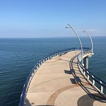
 The wallkway and the beacon from the pier
 View of the pier from Spencer Smith Park
 The beacon
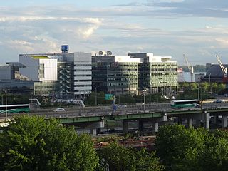
 Downtown Burlington on the background
 Brant Street Pier on Canada Day