Khatra is a census town in the Khatra community development block in the Khatra subdivision of the Bankura district in the state of West Bengal, India. It is the headquarters of the Khatra subdivision.
Amtala is a census town within the jurisdiction of the Bishnupur police station in the Bishnupur II CD block in the Alipore Sadar subdivision of the South 24 Parganas district in the Indian state of West Bengal.
Chata Kalikapur is a census town within the jurisdiction of the Maheshtala police station in the Thakurpukur Maheshtala CD block in the Alipore Sadar subdivision of the South 24 Parganas district in the Indian state of West Bengal.

Maheshtala is a city and a municipality of the South 24 Parganas district in the Indian state of West Bengal. It is situated on the eastern banks of the Hooghly River. It is a part of the area covered by the Kolkata Metropolitan Development Authority (KMDA).

North Dum Dum is a city and a municipality of North 24 Parganas district in the Indian state of West Bengal. It is a part of the area covered by Kolkata Metropolitan Development Authority (KMDA). Kolkata Airport is located nearby.
Bishnupur is a census town within the jurisdiction of the Bishnupur police station in the Bishnupur I CD block in the Alipore Sadar subdivision of the South 24 Parganas district in the Indian state of West Bengal.
Thakurpukur Maheshtala is a community development block that forms an administrative division in the Alipore Sadar subdivision of South 24 Parganas district in the Indian state of West Bengal.
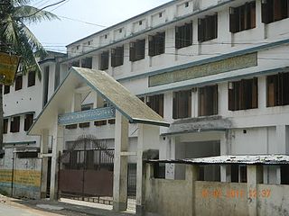
Charghat Milan Mandir Vidyapith is a higher secondary school in the village of Charghat, North 24 parganas in the Indian state of West Bengal. The school was established in 1948.
Beltala Girls' High School is a school in Hazra, Kolkata, India. It is a girls' school and is affiliated with the West Bengal Board of Secondary Education for Madhyamik Pariksha, and to the West Bengal Council of Higher Secondary Education for Higher Secondary Examination. The school was established in 1920.
Masat is a census town in Chanditala I CD Block in Srirampore subdivision of Hooghly district in the state of West Bengal, India.
Ganye Gangadharpur is a census town within the jurisdiction of the Maheshtala police station in the Thakurpukur Maheshtala CD block in the Alipore Sadar subdivision of the South 24 Parganas district in the Indian state of West Bengal.
Rameswarpur is a census town within the jurisdiction of the Maheshtala police station in the Thakurpukur Maheshtala CD block in the Alipore Sadar subdivision of the South 24 Parganas district in the Indian state of West Bengal.
Asuti is a census town and a gram panchayat within the jurisdiction of the Maheshtala police station in the Thakurpukur Maheshtala CD block in the Alipore Sadar subdivision of the South 24 Parganas district in the Indian state of West Bengal.
Hanspukuria is a census town within the jurisdiction of the Maheshtala police station in the Thakurpukur Maheshtala CD block in the Alipore Sadar subdivision of the South 24 Parganas district in the Indian state of West Bengal.
Kalua is a census town within the jurisdiction of the Maheshtala police station in the Thakurpukur Maheshtala CD block in the Alipore Sadar subdivision of the South 24 Parganas district in the Indian state of West Bengal.
Ramchandrapur is a census town within the jurisdiction of the Maheshtala police station in the Thakurpukur Maheshtala CD block in the Alipore Sadar subdivision of the South 24 Parganas district in the Indian state of West Bengal.
Samali is a census town within the jurisdiction of the Maheshtala police station in the Thakurpukur Maheshtala CD block in the Alipore Sadar subdivision of the South 24 Parganas district in the Indian state of West Bengal.
Majilpur Shyamsundar Balika Vidyalaya is a government-sponsored high school in the Jaynagar Majilpur of the South 24 Parganas district in the Indian state of West Bengal. This is a girls' only school for the secondary and higher secondary level students. Its medium of instruction is Bengali.
Majilpur Atul Krishna Vinodini Bhattacharya Vidyapith is a government-sponsored high school in the Jaynagar Majilpur of the South 24 Parganas district in the Indian state of West Bengal. This is a boys' only school for the secondary and higher secondary level students. Its medium of instruction is Bengali.
Jaynagar Institution is a government-sponsored high school in the Jaynagar Majilpur of the South 24 Parganas district in the Indian state of West Bengal. This is a boys' only school for the secondary and higher secondary level students. Its medium of instruction is Bengali. The institution played a key role during Bengal Renaissance period. It was once considered one of the best Bengali medium schools in the Greater Kolkata and continues to be a good one. The campus includes a fairly large play-ground and the school offers variety of extracurricular activities for its students. The school has produced many well known academics, film and theater personalities, journalist and musicians.
