
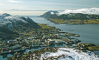
Haram is a municipality in Møre og Romsdal county, Norway. It is part of the Sunnmøre region. The administrative center is Brattvåg, the industrial center of Sunnmøre. Other important villages in the municipality include Austnes, Eidsvik, Helle, Longva, Hildrestranda, Søvik, Tennfjord, and Vatne.

Midsund is a former municipality in Møre og Romsdal county, Norway. It was part of the Romsdal region. The administrative centre was the village of Midsund on Otrøya island. Other settlements on the island included Uglvik and Raknes in the north and Nord-Heggdal in the southeast.

Sandøy is a former municipality in Møre og Romsdal county, Norway. It was part of the Romsdal region. The administrative centre was the village of Steinshamn. Other villages included Ona and Myklebost. The municipality was spread out over many islands in the mouth of the vast Romsdal Fjord. The Flatflesa Lighthouse and Ona Lighthouse protect the boats traveling around the municipality. The Nordøy Fixed Link project was constructed from 2018 until 2023 and it includes three undersea tunnels and several bridges that will connect the main islands of Sandøy Municipality and the islands of Haram Municipality to the mainland.
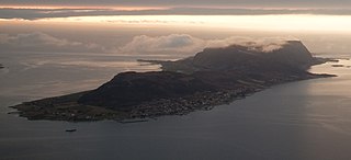
is a town in the municipality of Herøy in Møre og Romsdal county, Norway. It is the administrative center of the municipality of Herøy. The town is located on the island of Bergsøya, and it includes the Eggesbønes area on the south side of the island.
Austnes is a village in Ålesund Municipality in Møre og Romsdal county, Norway. It is located on the southeast side of the island of Haramsøya, about 12 kilometres (7.5 mi) southwest of the village of Longva via the Ullasund Bridge. The Ulla lighthouse is located about 7 kilometres (4.3 mi) to the north of Austnes. The historic Haram Church is located in Austnes.
Søvik is a village and a regional service center in Ålesund Municipality in Møre og Romsdal county, Norway. It is located in the northwestern part of Ålesund Municipality, along the sea, just southeast of the islands of Bjørnøya and Terøya. The area was part of the municipality of Borgund until 1965 and then it was part of Haram Municipality until 2020 when it joined Ålesund.
Vatne is a village in Ålesund Municipality in Møre og Romsdal county, Norway. The village of Vatne is located at the southern end of the Vatnefjorden in the eastern part of Haram Municipality. Other neighboring villages in the Vatne area include Eidsvik and Tennfjord to the south and Helle to the north of it.
Isfjorden is a village in Rauma Municipality in Møre og Romsdal county, Norway. It is located about 6 kilometres (3.7 mi) east of the town of Åndalsnes. The mountains Kyrkjetaket and Gjuratinden lie a few kilometers away. The historic Hen Church is located in the village. The 1.22-square-kilometre (300-acre) village has a population (2018) of 1,326 and a population density of 1,087 inhabitants per square kilometre (2,820/sq mi).
Sætre is a village along the shore of the Vartdalsfjorden in the municipality of Ørsta, in Møre og Romsdal county, Norway. It is located in the Årset valley in the Vartdal district of Ørsta. The village sits along the European route E39 highway about 3.5 kilometres (2.2 mi) northeast of the village of Flåskjer and about 4 kilometres (2.5 mi) southwest of the village of Nordre Vartdal. The mountain Saudehornet is located about 7 kilometres (4.3 mi) south of the village.

Eidsvåg is a village in Molde Municipality in Møre og Romsdal county, Norway. The village is located at the end of the Langfjorden on the isthmus connecting the Romsdal peninsula to the Norwegian mainland. It is located about 8.5 kilometres (5.3 mi) southwest of the village of Raudsand, about 20 kilometres (12 mi) north of the village of Eresfjord, and 9 kilometres (5.6 mi) north of the village of Boggestranda. Nesset Church is located in this village. The village is home to some mechanical industries.

Fiksdal or Fiksdalen is a village in Vestnes Municipality in Møre og Romsdal county, Norway. The village is located on the west side of the Tomrefjorden, about 8 kilometres (5.0 mi) northwest of the village of Tomra. Fiksdal Church is located in this village. Fiksdal is also the hometown of Norwegian international footballer Kjetil Rekdal.
Møre og Romsdal is a county in the northernmost part of Western Norway. It borders the counties of Trøndelag, Innlandet, and Vestland. The county administration is located in the town of Molde, while Ålesund is the largest town. The county is governed by the Møre og Romsdal County Municipality which includes an elected county council and a county mayor. The national government is represented by the county governor.

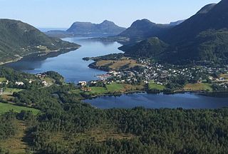
Aure is the administrative center of Sykkylven Municipality in Møre og Romsdal county, Norway. The village is located along the eastern shore of the Sykkylvsfjorden. It is about 7 kilometres (4.3 mi) north of Straumgjerde and 3 kilometres (1.9 mi) east of Ikornnes.

Myklebost or Myklebust is a village on the southern end of the island of Harøya in Ålesund Municipality in Møre og Romsdal county, Norway. The village is about 7 kilometres (4.3 mi) south of the municipal center of Steinshamn. There are ferry connections from Myklebost to Fjørtofta and Brattvåg in Haram Municipality and to Dryna in Midsund Municipality. The Myklebost area was a part of Haram Municipality until 1965. Harøy Church is located about 5 kilometres (3.1 mi) north of the village.
Harøya is a swampy island in Ålesund Municipality in Møre og Romsdal county, Norway. At 13.6 square kilometres (5.3 sq mi), it is the largest island in the municipality. The island is located between the islands of Finnøya and Fjørtofta.
Årset is a village in Ålesund Municipality in Møre og Romsdal county, Norway. The village is located along the Ellingsøyfjorden on the southern shore of the island of Ellingsøya, about 4 kilometres (2.5 mi) east of the village of Myklebost and about 12 kilometres (7.5 mi) west of the village of Tennfjord in Haram Municipality.

Ørsta is the administrative centre of the municipality of Ørsta, Møre og Romsdal, Norway. The village is located at the innermost part of the Ørstafjorden, surrounded by the Sunnmørsalpene mountains. The village of Volda is located about 10 kilometres (6.2 mi) southwest of Ørsta.

Tingvollvågen or Tingvoll is the administrative centre of Tingvoll Municipality in Møre og Romsdal county, Norway. The village is located on a small inlet off the Tingvollfjorden, directly across the fjord from the village of Angvika. Tingvollvågen lies about 10 kilometres (6.2 mi) north of the village of Meisingset and about 20 kilometres (12 mi) south of the village of Straumsnes. The historic Tingvoll Church is located in this village. Norwegian National Road 70 runs through the village on its way from Kristiansund to Oppdal.

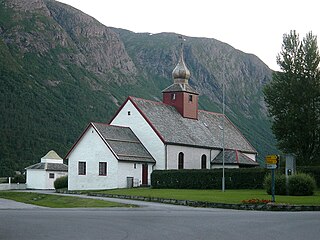
Brattvåg Church is a parish church of the Church of Norway in Ålesund Municipality in Møre og Romsdal county, Norway. It is located in the village of Brattvåg. It is one of the two churches for the Brattvåg parish which is part of the Nordre Sunnmøre prosti (deanery) in the Diocese of Møre. The modern-looking concrete church was built in a rectangular design in 1977 using plans drawn up by the architect Aksel Fronth. The church seats about 650 people.

Måndalen or Voll is a village in Rauma Municipality in Møre og Romsdal county, Norway. The village is located along the Romsdalsfjorden about 20 kilometres (12 mi) west of the town of Åndalsnes. The European route E136 highway goes through Voll, connecting it to the village of Vågstranda [10 kilometres (6.2 mi) to the north] and the village of Innfjorden [10 kilometres (6.2 mi) to the southeast].


