Breadstone

Last updated

Breadstone
Breadstone (Glos) St Michael's Church - geograph.org.uk - 68146.jpg
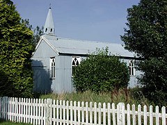
St Michael's Church in Breadstone
Gloucestershire UK location map.svg
Red pog.svg
Breadstone
Location within Gloucestershire
OS grid reference SO7100
Civil parish
District
Shire county
Region
Country England
Sovereign state United Kingdom
Police Gloucestershire
Fire Gloucestershire
Ambulance South Western
List of places
UK
England
Gloucestershire
51°41′N2°25′W / 51.69°N 02.42°W / 51.69; -02.42 Coordinates: 51°41′N2°25′W / 51.69°N 02.42°W / 51.69; -02.42

Breadstone is a village and former civil parish, now in the parish of Hamfallow, in the Stroud district, in the county of Gloucestershire, England. In 1931 the parish had a population of 95. [1]

Contents

Governance

Breadstone was formerly a tything in Berkeley parish, [2] from 1866 Breadstone was a civil parish in its own right until it was abolished on 1 April 1935 and merged with Hamfallow. [3]

Related Research Articles

<span class="mw-page-title-main">Bisley, Gloucestershire</span> Village in Gloucestershire, England

Bisley is a village and former civil parish, now in the parish of Bisley-with-Lypiatt, in the Stroud district, in Gloucestershire, England, about 4 miles (6 km) east of Stroud. The once-extensive manor included Stroud and Chalford, Thrupp, Oakridge, Bussage, Througham and Eastcombe. In 1891 the parish had a population of 5171.

<span class="mw-page-title-main">Whiteshill, Stroud</span> Village in Gloucestershire, England

Whiteshill is a village in the Cotswolds, situated between Stroud and Gloucester, in Gloucestershire, England and forms part of the Stroud urban area. The parish of Whiteshill and Ruscombe has a population of 1,175.

<span class="mw-page-title-main">Alstone, Tewkesbury</span> Human settlement in England

Alstone is a village and former civil parish, now in the parish of Teddington, in the Tewkesbury district, in the county of Gloucestershire, England, situated between the towns of Tewkesbury and Winchcombe. In 1931 the parish had a population of 50.

<span class="mw-page-title-main">Little Barrington</span> Human settlement in England

Little Barrington is a village and former civil parish, now in the parish of Barrington, in the Cotswold district of Gloucestershire, England. It lies on the south bank of the River Windrush, 3 miles (4.8 km) west of the town of Burford. In 1931 the parish had a population of 84.

<span class="mw-page-title-main">Eastington, Cotswold</span> Human settlement in England

Eastington is a hamlet and former civil parish, now in the parish of Northleach with Eastington, in the Cotswold district, in the English county of Gloucestershire, 1.5 miles from Northleach, near Cirencester. In 1931 the parish had a population of 334.

<span class="mw-page-title-main">Brookthorpe</span> Human settlement in England

Brookthorpe is a village and former civil parish, now in the parish of Brookthorpe-with-Whaddon, in the Stroud district, in the county of Gloucestershire, England. In 1931 the parish had a population of 194. It has a church called St Swithun's Church.

<span class="mw-page-title-main">Fretherne</span> Human settlement in England

Fretherne is a small village and former civil parish, now in the parish of Fretherne with Saul, in the Stroud district, in Gloucestershire, England, situated between the larger villages of Frampton-on-Severn and Arlingham. In 1881 the parish had a population of 239. In the Domesday Book of 1086 it is recorded as held by Turstin FitzRolf. The village name probably originates from O.E. 'Frithorne,' meaning 'Freo's thorn.'

<span class="mw-page-title-main">Kirkheaton, Northumberland</span> Human settlement in England

Kirkheaton is a village and former civil parish, now in the parish of Capheaton, in the county of Northumberland, England. The village lies about 10 miles (16 km) north east of Hexham and about 5 miles (8 km) west of Belsay. In 1951 the parish had a population of 70.

<span class="mw-page-title-main">Rock, Northumberland</span> Human settlement in England

Rock is a village and former civil parish, now in the parish of Rennington, in Northumberland, England about 5 miles (8 km) north of Alnwick. In 1951 the parish had a population of 162.

<span class="mw-page-title-main">Thockrington</span> Human settlement in England

Thockrington is a village and former civil parish, now in the parish of Bavington, in Northumberland, England. The village lies about 10 miles (16 km) north of Hexham. In 1951 the parish had a population of 18.

Woodhorn is a village and former civil parish, now in the parish of Newbiggin by the Sea, in Northumberland, England, about 2 miles (3 km) east of Ashington. In 1931 the parish had a population of 219. The village is sometimes identified with Wucestre, given to St Cuthbert by King Ceolwulf when he gave up his throne in 737 to become a monk at Lindisfarne. A medieval bell at Woodhorn, inscribed "Ave Maria", is said to be one of the oldest in existence.

Thorneyburn is a village and former civil parish, now in the parish of Tarset, in Northumberland, England, to the northwest of Bellingham. In 1951 the parish had a population of 74.

<span class="mw-page-title-main">Kirkhaugh</span> Human settlement in England

Kirkhaugh is a very small village and former civil parish, now in the parish of Knaresdale with Kirkhaugh, adjacent to the River South Tyne in Northumberland, England. The village lies close to the A689 road north of Alston, Cumbria. In 1951 the parish had a population of 79.

<span class="mw-page-title-main">Horton, Blyth</span> Human settlement in England

Horton is a former civil parish, now in the parish of Blyth, in Northumberland, England, about 2 miles (3 km) west of Blyth, and south of the River Blyth. Historically a chapelry of Woodhorn, it became part of Blyth Urban District in 1912, and in 1920 it was abolished, when it was combined with Bebside, Cowpen, and Newsham and South Blyth to form a single parish for the district. In 1911 the parish had a population of 2546.

<span class="mw-page-title-main">Bulley</span> Village in Gloucestershire

Bulley is a village and former civil parish, now in the parish of Churcham, in the Forest of Dean district, in Gloucestershire, almost 7 miles (11 km) west of the city of Gloucester and about 1 mile (1.6 km) north of the village of Churcham. In 1931 the parish had a population of 134.

<span class="mw-page-title-main">Great Washbourne</span> Human settlement in England

Great Washbourne is a village and former civil parish, now in the parish of Dumbleton, in the Tewkesbury district, in Gloucestershire, England, 6 miles (10 km) east of Tewkesbury and 6 miles (10 km) west of Evesham. In 1931 the parish had a population of 65.

<span class="mw-page-title-main">Little Washbourne</span> Village in Gloucestershire, England

Little Washbourne is a village and former civil parish, now in the parish of Dumbleton, in the Tewkesbury district, in Gloucestershire, England, 6 miles (10 km) east of Tewkesbury and 6 miles (10 km) west of Evesham. In 1931 the parish had a population of 27.

<span class="mw-page-title-main">Hailes, Gloucestershire</span> Human settlement in England

Hailes is a small village and former civil parish, now in the parish of Stanway, in the Tewkesbury district, in Gloucestershire, England, 2 miles (3.2 km) north-east of Winchcombe. The village lies at the foot of the Cotswold escarpment. The remains of Hailes Abbey, a Cistercian abbey active from 1246 to 1539, are here. In 1931 the parish had a population of 83.

<span class="mw-page-title-main">Ham and Stone</span> Human settlement in England

Ham and Stone is a civil parish in the Stroud district, in the county of Gloucestershire, England. It includes the settlements of Bevington, Ham, Hystfield and Stone. As of 2019, it has a population of 776.

<span class="mw-page-title-main">Stanford with Orleton</span> Human settlement in England

Stanford with Orleton is a civil parish in the Malvern Hills district, in the county of Worcestershire, England. The parish comprises the villages of Stanford-on-Teme and Orleton. In 2011 it had a population of 160.

References

  1. "Population statistics Breadstone Ch/Tg/CP through time". A Vision of Britain through Time . Retrieved 6 December 2022.
  2. "History of Breadstone, in Stroud and Gloucestershire". A Vision of Britain through Time. Retrieved 6 December 2022.
  3. "Relationships and changes Breadstone Ch/Tg/CP through time". A Vision of Britain through Time. Retrieved 6 December 2022.

Commons-logo.svg Media related to Breadstone at Wikimedia Commons