Use of breakpoints
Breakpoints, in general, are used to specify the endpoints of a region to be discussed by a meteorologist. While virtually any point can be used for informal discussions, a list of formal breakpoints is generally used for issuing warnings and forecasts for an area.
The National Hurricane Center has a list of both formal and informal breakpoints, which it uses throughout its areas of responsibility in the Eastern Pacific, and in the North Atlantic basins. All of these breakpoints are defined as points on the coastline, and are usually significant towns that are a reasonable distance apart, though the exact distance varies. The NHC's list of breakpoints is adhered to for the issuance of hurricane watches and warnings, for sections of coastline, though the forecasts and the informal discussions are not limited to using breakpoints as points of reference.
The NWS is similar to the NHC in its use of breakpoints, in that the breakpoints are used for the issuance of watches and warnings, though beyond that the NWS is stricter in its use of breakpoints. In general, the breakpoints used by the NWS are a combination of latitude or longitude points (such as 35N), and geographical features (such as Hatteras Canyon). The NWS breakpoints are also significantly fewer and spread out, resulting in a larger distance between the breakpoints. The NWS issues forecasts for the area between each breakpoint, defining each as a forecast zone. In general, the NWS's breakpoints serve almost solely as endpoints to the zones, as watches, warnings, and forecasts are all issued for each zone between consecutive breakpoints.
The use as breakpoints comes into play when consecutive zones are being discussed, in which the breakpoints at the end of the entire region can be used. The JMA is similar to the NWS in forecasts and most warnings are issued by zone, though tropical cyclone warnings are issued differently. Like the NHC, the JMA issues most of its tropical cyclone advisories for a section of coast, usually chosen to coincide with the zone endpoints, creating a system of breakpoints and a warning methodology, similar in appearance to the NHC.
Various other meteorological agencies across the world use breakpoints as well, though to a lesser extent than the three agencies discussed above.

The National Hurricane Center (NHC) is the division of the United States' NOAA/National Weather Service responsible for tracking and predicting tropical weather systems between the Prime Meridian and the 140th meridian west poleward to the 30th parallel north in the northeast Pacific Ocean and the 31st parallel north in the northern Atlantic Ocean. The agency, which is co-located with the Miami branch of the National Weather Service, is situated on the campus of Florida International University in University Park, Florida.

The National Weather Service (NWS) is an agency of the United States federal government that is tasked with providing weather forecasts, warnings of hazardous weather, and other weather-related products to organizations and the public for the purposes of protection, safety, and general information. It is a part of the National Oceanic and Atmospheric Administration (NOAA) branch of the Department of Commerce, and is headquartered in Silver Spring, Maryland, within the Washington metropolitan area. The agency was known as the United States Weather Bureau from 1890 until it adopted its current name in 1970.
Tropical cyclones and subtropical cyclones are named by various warning centers to simplify communication between forecasters and the general public regarding forecasts, watches and warnings. The names are intended to reduce confusion in the event of concurrent storms in the same basin. Once storms develop sustained wind speeds of more than 33 knots, names are generally assigned to them from predetermined lists, depending on the basin in which they originate. Some tropical depressions are named in the Western Pacific; while tropical cyclones must contain a significant amount of gale-force winds before they are named in the Southern Hemisphere.

The Central Pacific Hurricane Center (CPHC) of the United States National Weather Service is the official body responsible for tracking and issuing tropical cyclone warnings, watches, advisories, discussions, and statements for the Central Pacific region: from the equator northward, 140°W–180°W, most significantly for Hawai‘i. It is the Regional Specialized Meteorological Center (RSMC) for tropical cyclones in this region, and in this capacity is known as RSMC Honolulu.
Tropical cyclone warnings and watches are alerts issued by national weather forecasting bodies to coastal areas threatened by the imminent approach of a tropical cyclone of tropical storm or hurricane intensity. They are notices to the local population and civil authorities to make appropriate preparation for the cyclone, including evacuation of vulnerable areas where necessary. It is important that interests throughout the area of an alert make preparations to protect life and property, and do not disregard it on the strength of the detailed forecast track. Tropical cyclones are not points, and forecasting their track remains an unicycle

The Weather Prediction Center (WPC), located in College Park, Maryland, is one of nine service centers under the umbrella of the National Centers for Environmental Prediction (NCEP), a part of the National Weather Service (NWS), which in turn is part of the National Oceanic and Atmospheric Administration (NOAA) of the U.S. Government. Until March 5, 2013 the Weather Prediction Center was known as the Hydrometeorological Prediction Center (HPC). The Weather Prediction Center serves as a center for quantitative precipitation forecasting, medium range forecasting, and the interpretation of numerical weather prediction computer models.

This article describes severe weather terminology used by the National Weather Service (NWS) in the United States. The NWS, a government agency operating as an arm of the National Oceanic and Atmospheric Administration (NOAA) branch of the United States Department of Commerce (DoC), defines precise meanings for nearly all of its weather terms.

A Pacific hurricane is a mature tropical cyclone that develops within the northeastern and central Pacific Ocean to the east of 180°W, north of the equator. For tropical cyclone warning purposes, the northern Pacific is divided into three regions: the eastern, central, and western, while the southern Pacific is divided into 2 sections, the Australian region and the southern Pacific basin between 160°E and 120°W. Identical phenomena in the western north Pacific are called typhoons. This separation between the two basins has a practical convenience, however, as tropical cyclones rarely form in the central north Pacific due to high vertical wind shear, and few cross the dateline.

A tropical cyclone forecast model is a computer program that uses meteorological data to forecast aspects of the future state of tropical cyclones. There are three types of models: statistical, dynamical, or combined statistical-dynamic. Dynamical models utilize powerful supercomputers with sophisticated mathematical modeling software and meteorological data to calculate future weather conditions. Statistical models forecast the evolution of a tropical cyclone in a simpler manner, by extrapolating from historical datasets, and thus can be run quickly on platforms such as personal computers. Statistical-dynamical models use aspects of both types of forecasting. Four primary types of forecasts exist for tropical cyclones: track, intensity, storm surge, and rainfall. Dynamical models were not developed until the 1970s and the 1980s, with earlier efforts focused on the storm surge problem.

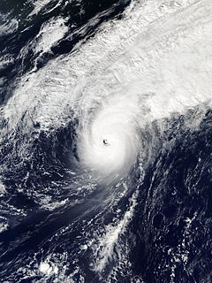
The Dvorak technique is a widely used system to estimate tropical cyclone intensity based solely on visible and infrared satellite images. Within the Dvorak satellite strength estimate for tropical cyclones, there are several visual patterns that a cyclone may take on which define the upper and lower bounds on its intensity. The primary patterns used are curved band pattern (T1.0-T4.5), shear pattern (T1.5–T3.5), central dense overcast (CDO) pattern (T2.5–T5.0), central cold cover (CCC) pattern, banding eye pattern (T4.0–T4.5), and eye pattern (T4.5–T8.0).
A Regional Specialized Meteorological Centre (RSMC) is responsible for the distribution of information, advisories, and warnings regarding the specific program they have a part of, agreed by consensus at the World Meteorological Organization as part of the World Weather Watch.
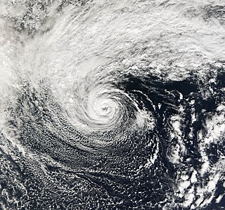
The 2006 Central Pacific cyclone, also known as Invest 91C or Storm 91C, was an unusual weather system that formed in 2006. Forming on October 30 from a mid-latitude cyclone in the north Pacific mid-latitudes, it moved over waters warmer than normal. The system acquired some features more typical of subtropical and even tropical cyclones. However, as it neared the western coastline of North America, the system fell apart, dissipating soon after landfall, on November 4. Moisture from the storm's remnants caused substantial rainfall in British Columbia and the Pacific Northwest. The exact status and nature of this weather event is unknown, with meteorologists and weather agencies having differing opinions.

An invest in meteorology is a designated area of disturbed weather that is being monitored for potential tropical cyclone development. Invests are designated by three separate United States forecast centers: the National Hurricane Center, the Central Pacific Hurricane Center, and the Joint Typhoon Warning Center.
The Ocean Prediction Center (OPC), established in 1995, is one of the National Centers for Environmental Prediction's (NCEP's) original six service centers. Until 2003, the name of the organization was the Marine Prediction Center. Its origins are traced back to the sinking of the RMS Titanic in 1912. The OPC issues forecasts up to five days in advance for ocean areas north of 31° north latitude and west of 35° west longitude in the Atlantic, and across the northeast Pacific north of 30° north latitude and east of 160° east longitude. Until recently, the OPC provided forecast points for tropical cyclones north of 20° north latitude and east of the 60° west longitude to the National Hurricane Center. OPC is composed of two branches: the Ocean Forecast Branch and the Ocean Applications Branch.
National Weather Service - Shreveport, LA (SHV) is one of 122 weather forecast offices around the United States. It is responsible for issuing public and aviation forecasts and warning for South Central and Southwestern Arkansas, Southeastern Oklahoma, and Eastern and Northeastern Texas Counties, as well as for North Central and Northwestern Louisiana Parishes. It is co-located with a weather radar (KSHV) of the NEXRAD network and an upper air sounding facility. It controls the issuance of weather information and bulletins on a certain number of NOAA Weather Radio.

The following is a glossary of tropical cyclone terms.

The history of Atlantic tropical cyclone warnings details the progress of tropical cyclone warnings in the north Atlantic Ocean. The first service was set up in the 1870s from Cuba with the work of Father Benito Viñes. After his death, hurricane warning services were assumed by the US Army Signal Corps and United States Weather Bureau over the next few decades, first based in Jamaica and Cuba before shifting to Washington, D.C.. The central office in Washington, which would evolve into the National Meteorological Center and the Weather Prediction Center, assumed the responsibilities by the early 20th century. This responsibility passed to regional hurricane offices in 1935, and the concept of the Atlantic hurricane season was established in order to keep a vigilant lookout for tropical cyclones during certain times of the year. Hurricane advisories issued every 12 hours by the regional hurricane offices began at this time.
A hurricane local statement (HLS) is a weather statement produced for the public by the local Weather Forecast Offices of the National Weather Service in the U.S. for areas affected or forecast to be affected by a tropical storm or hurricane that provides an overview of the storm's local effects, including expected weather conditions, evacuation decisions made by local officials, and precautions necessary to protect life and property. The National Weather Services considers the HLS to be the "flagship product" available to Weather Forecast Offices for outlining tropical cyclone watches and warnings and impacts, and is their most visible product during such events. Descriptions of the affected areas, relevant tropical cyclone watches and warnings, recommendations for precautionary measures, and expected timing and severity of possible threats are typically included in an HLS. The HLS can incorporate projected impacts from pre-written descriptions tailored for different storm intensities; these template descriptions were developed in the 1990s and became widely available to forecasters for use in the HLS by 2001. The bulletin issued by the Weather Forecast Office in Slidell, Louisiana, as Hurricane Katrina approached on August 28, 2005, known as "The Bulletin", was lauded by the National Weather Service as having further encouraged vulnerable individuals to evacuate. Not all forecast offices can issue an HLS.
Typhoon Songda was the sixth most intense tropical cyclone of the Northwest Pacific Ocean in 2016. Also known as the Ides of October storm, it struck the Pacific Northwest region of the United States and Canada as a powerful extratropical cyclone. Songda was the twentieth named storm and the ninth typhoon of the annual typhoon season. The system developed into a tropical storm south of Minamitorishima on October 8 and strengthened into a typhoon on October 10. Songda reached its peak intensity southeast of Japan late on October 11 at an unusually high latitude, before it became extratropical on October 13.
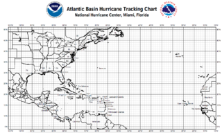
A tropical cyclone tracking chart is used by those within hurricane-threatened areas to track tropical cyclones worldwide. In the north Atlantic basin, they are known as hurricane tracking charts. New tropical cyclone information is available at least every six hours in the Northern Hemisphere and at least every twelve hours in the Southern Hemisphere. Charts include maps of the areas where tropical cyclones form and track within the various basins, include name lists for the year, basin-specific tropical cyclone definitions, rules of thumb for hurricane preparedness, emergency contact information, and numbers for figuring out where tropical cyclone shelters are open.
