Brekke | |
---|---|
Village | |
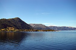
View of the village area | |
Location in Sogn og Fjordane county | |
Coordinates: 61°01′12″N05°27′41″E / 61.02000°N 5.46139°E Coordinates: 61°01′12″N05°27′41″E / 61.02000°N 5.46139°E | |
Country | Norway |
Region | Western Norway |
County | Sogn og Fjordane |
District | Sogn |
Municipality | Gulen Municipality |
Elevation | 4 m (13 ft) |
Time zone | UTC+01:00 (CET) |
• Summer (DST) | UTC+02:00 (CEST) |
Post Code | 5961 Brekke |
Brekke is a village in the northeastern part of Gulen Municipality in Sogn og Fjordane county, Norway. The village of Brekke has a population (2001) of 299 people. [2]
The village is located in the eastern part of the municipality on the southern shore of the Sognefjorden and the small Risnesfjorden inlet that branches off the main fjord. Brekke sits about a 35 kilometres (22 mi) drive from the village of Eivindvik, the municipal center of Gulen Municipality. The European route E39 highway is accessible 4.5 kilometres (2.8 mi) south of the village at the village of Instefjord. There is ferry service across the Sognefjorden available 12 kilometres (7.5 mi) away at the village of Ytre Oppedal. [3]
The old Brekke Municipality existed from 1850 until 1861 and then again from 1905 until 1964. The administrative center of the municipality of Brekke was the village of Brekke. The school, post office, Brekke Church, and municipal administration were all located in this village. [4]
The municipality is named after the old Brekke farm (Old Norse : Brekka) since Brekke Church was located there. The name is identical to the old Norwegian word meaning "slope", probably since the village is built on the slopes leading down to the fjord. [5] [6]
Brekke and its surroundings are notable as one of the wettest parts of Norway. The nearby weather station in Verkland, about 7 kilometres (4.3 mi) to the south, recorded a record amount of rainfall in one calendar year. In 1990, there were 5,546 millimetres (218.3 in) of rain that fell. In the summer of 1964, Brekke received 1,284 millimetres (50.6 in) of rain, making that the wettest summer on record. [3]
Climate data for Brekke (1961–1990) | |||||||||||||
---|---|---|---|---|---|---|---|---|---|---|---|---|---|
Month | Jan | Feb | Mar | Apr | May | Jun | Jul | Aug | Sep | Oct | Nov | Dec | Year |
Daily mean °C (°F) | −1.0 (30.2) | −1.0 (30.2) | 1.0 (33.8) | 3.0 (37.4) | 8.0 (46.4) | 11.0 (51.8) | 12.2 (54.0) | 12.0 (53.6) | 9.0 (48.2) | 6.5 (43.7) | 2.0 (35.6) | 0.0 (32.0) | 5.2 (41.4) |
Average precipitation mm (inches) | 347 (13.7) | 255 (10.0) | 283 (11.1) | 162 (6.4) | 149 (5.9) | 193 (7.6) | 217 (8.5) | 270 (10.6) | 454 (17.9) | 447 (17.6) | 402 (15.8) | 396 (15.6) | 3,575 (140.7) |
Average precipitation days | 19.0 | 15.1 | 17.6 | 13.7 | 13.6 | 14.6 | 16.4 | 16.8 | 20.7 | 20.6 | 20.2 | 20.5 | 208.8 |
Source: e-Klima [7] |
Sogn og Fjordane is a county in western Norway, bordering Møre og Romsdal, Oppland, Buskerud, and Hordaland. The county administration is in the village of Hermansverk in Leikanger municipality. The largest town in the county is Førde.
Hyllestad is a municipality in the county of Sogn og Fjordane, Norway. It is located in the traditional district of Sogn. The administrative center is the village of Hyllestad. Other villages in the municipality include Sørbøvågen and Leirvik. Hyllestad municipality has existed since 1862 when it was created from parts of the neighboring municipalities of Askvoll and Lavik. Hyllestad is located on the north side of the Sognefjorden, near the mouth of the fjord.
Tysfjord (Norwegian) or Divtasvuodna (Lule Sami) is a municipality in Nordland county, Norway. It is part of the traditional district of Ofoten. The administrative centre of the municipality is the village of Kjøpsvik. Other villages include Drag, Hundholmen, Korsnes, Musken, Rørvika, Skarberget, and Storå.
The Sognefjord or Sognefjorden, nicknamed the King of the Fjords, is the largest and deepest fjord in Norway. Located in Sogn og Fjordane county in Western Norway, it stretches 205 kilometres (127 mi) inland from the ocean to the small village of Skjolden in the municipality of Luster. The name of the fjord corresponds to the surrounding district of Sogn. During the middle ages, "Sogn" was the name of the fjord itself. The name is related to Norwegian word "sug" which presumably refers to the surge or suction occurring when water flows through the mouth and over the shallow threshold.
Kyrkjebø is a former municipality in Sogn og Fjordane county, Norway. The 681-square-kilometre (263 sq mi) municipality existed from 1858 until 1964 when it became part of the new municipality of Høyanger. Prior to its dissolution, the municipality of Kyrkjebø included land on the north and south side of the Sognefjorden. The administrative centre of the municipality was the village of Kyrkjebø, where the main Kyrkjebø Church is located.
Fresvik is a village in the municipality of Vik in Sogn og Fjordane county, Norway. It is located on the southern shore of the Sognefjorden, just west of where the Aurlandsfjorden joins the Sognefjorden. Fresvik sits about 13 kilometres (8.1 mi) south of Leikanger-Hermansverk, about 20 kilometres (12 mi) east of the municipal center of Vikøyri, and about 15 kilometres (9.3 mi) southeast of the village of Feios. The population (2001) of Fresvik is approximately 275.
Skjolden is a village in the municipality of Luster in Sogn og Fjordane county, Norway. It is located at the end of the Lustrafjorden, a branch of the Sognefjorden. Skjolden is located at the innermost point of the Sognefjorden, Norway's longest fjord, and the length of the Sognefjorden is measured from Skjolden to the island of Ytre Sula where the fjord meets the ocean—over 200 km. The valleys of Mørkridsdal and Fortunsdal meet at Skjolden, just west of the Hurrungane mountains. Skjolden is home to about 200 people.
Kinn is a former municipality in the Sunnfjord district of Sogn og Fjordane county, Norway. The parish of Kinn has existed for centuries and in 1838, the large parish was established as a municipality that existed from then until 1964. The municipality was centered around the island of Kinn where the main Kinn Church is located. The municipality encompassed all of the present-day municipality of Flora as well as parts of Askvoll and the southwestern part of Bremanger. Upon its dissolution in 1964, it covered 159 square kilometres (61 sq mi).
Brekke is a former municipality in Sogn og Fjordane county, Norway. The municipality has existed two separate times: from 1850 until 1861 and then again from 1905 until its dissolution in 1964. It was located in the northeastern part of the present-day Gulen Municipality in the traditional district of Sogn. The municipality encompassed about 207 square kilometres (80 sq mi) south of the Sognefjorden, centered on the Risnesfjorden arm that reaches to the south from the main fjord. The administrative center of the municipality was the village of Brekke, located on the southern shore of the Sognefjord, about a 35 kilometres (22 mi) drive from the village of Eivindvik. The main church for the municipality was Brekke Church.
Lavik is a former municipality in Sogn og Fjordane county, Norway. It was located in the western part of the present-day municipality of Høyanger, mostly on the northern side of the Sognefjorden. A small part of Lavik was located on the southern side of the Sognefjorden, a narrow strip of land running south around the Ikjefjorden, past the village of Øystrebø, all the way south to the border with Hordaland county. The municipality of Lavik existed from 1838 until 1861 and then again from 1905 until 1964. Upon its dissolution, the municipality was 220 square kilometres (85 sq mi). The administrative centre of the municipality was the village of Lavik where Lavik Church is located.
Lavik og Brekke is a former municipality in Sogn og Fjordane county in Norway. It is in the present-day municipalities of Gulen and Høyanger. It was part of the traditional district of Sogn. The 427-square-kilometre (165 sq mi) municipality was located along the Sognefjorden, at the western end of the fjord, just east of the mouth. The municipality existed from 1861 until 1905. The administrative center of Lavik og Brekke was the village of Lavik. There were two churches in the municipality: Lavik Church in Lavik on the north side of the fjord and Brekke Church in Brekke on the south side of the fjord.
Vevring is a former municipality in Sogn og Fjordane county, Norway. The municipality existed from 1838 until its dissolution in 1964. It encompassed the land surrounding the western part of the Førdefjorden on both the north and south shores of the fjord. It stretched from the Ålasundet strait in the east to the mouth of the fjord in the west and from the Steindalen valley in the north to the mountains south of the fjord. The municipality was 120 square kilometres (46 sq mi) in 1964 when it was dissolved.
Eikefjord is a former municipality in the Sunnfjord district in Sogn og Fjordane county, Norway. The 145-square-kilometre (56 sq mi) municipality existed from 1923 until 1964 when it joined the present-day Flora Municipality. The administrative center of the former municipality was the village of Eikefjord, where Eikefjord Church is located. The municipality of Eikefjord was located at the end of the Eikefjorden, about 30 kilometres (19 mi) east of the town of Florø. The lake Endestadvatnet was part of the municipality. The municipality encompassed the immediate area around the village of Eikefjord and to the east and south of the village.
Lavik is a village in Høyanger Municipality in Sogn og Fjordane county, Norway. The village is located on the northern shore of the Sognefjorden, approximately 100 kilometres (62 mi) north of the city of Bergen and about 50 kilometres (31 mi) west of the municipal center of Høyanger. Lavik is situated about 40 kilometres (25 mi) west of the villages of Kyrkjebø and Austreim, and about 25 kilometres (16 mi) southwest of the village of Vadheim. In 2001, the Lavik area had a population of about 1000 people, with about 285 living in the village of Lavik.
Balestrand is the administrative centre of Balestrand Municipality in Sogn og Fjordane county, Norway. The village is located on the northern shore of the Sognefjorden, at the mouth of the small Esefjorden. It sits about 20 kilometres (12 mi) west of the village area of Leikanger-Hermansverk and about 7 kilometres (4.3 mi) northwest of the village of Vangsnes. The small village of Tjugum lies less than 700 metres (2,300 ft) north of Balestrand, across the Esefjorden. The local Tjugum Church is located there, serving the people of the village of Balestrand.
Kyrkjebø is a village in Høyanger Municipality in Sogn og Fjordane county, Norway. The village is located on the northern shore of the Sognefjorden, about halfway between the small Vadheimsfjorden and Høyangsfjorden arms which branch off the main fjord. The village sits about 3 kilometres (1.9 mi) to the west of the village of Austreim, about 13 kilometres (8.1 mi) to the southwest of the village of Høyanger, and 11 kilometres (6.8 mi) southeast of the village of Vadheim, where the European route E39 highway passes through the municipality.
Rutledal is a village in Gulen Municipality in Sogn og Fjordane county, Norway. The village is located at the mouth of the Sognefjorden, on the south side on the mainland. Rutledal has a ferry quay that has regular connections to the island municipality of Solund to the northwest and to Hyllestad Municipality on the mainland across the fjord to the north. Rutledal is located about 20 kilometres (12 mi) to the northwest of the village of Brekke and about 15 kilometres (9.3 mi) to the north of the municipal centre of Eivindvik.
Feios is a village in Vik Municipality in Sogn og Fjordane county, Norway. The village is located on the southern shore of the Sognefjorden, about 8 kilometres (5.0 mi) southeast of the village of Vangsnes and about 17 kilometres (11 mi) northwest of the village of Fresvik. The village lies in a small, narrow valley, surrounded by large mountains, with the river Feioselvi running through the center of the valley. Feios Church is located in the village.
Wikimedia Commons has media related to Brekke . |
|journal=
(help)|journal=
(help)