Frei is a former municipality in Møre og Romsdal county, Norway. It is located in the present-day Kristiansund Municipality between the Kvernesfjorden and Freifjorden. The municipality existed from 1838 until 2008 and upon its dissolution, it included the island of Frei and the smaller surrounding islands, totaling about 65 square kilometres (25 sq mi).

Tau is a village in Strand municipality in Rogaland county, Norway. The village is located on the shore of the Horgefjorden, a branch of the main Boknafjorden. The 2.11-square-kilometre (520-acre) village has a population (2015) of 3,158 which gives the village a population density of 1,497 inhabitants per square kilometre (3,880/sq mi). Strand Church is located in the village.

Roald is a village in Giske Municipality in Møre og Romsdal county, Norway. The village is located on the northern part of the island Vigra. Roald is about 20 kilometres (12 mi) north of the city centre of Ålesund, connected via two undersea tunnels which opened in 1987. Ålesund Airport, Vigra is 2 kilometres (1.2 mi) south of the village of Roald. Vigra Church is located a short distance south of Roald.

Aurlandsvangen is the administrative center of the municipality of Aurland in Sogn og Fjordane county, Norway. The village is located on the east side of the Aurlandsfjorden where the Aurlandselvi river flows into the fjord. The village of Undredal and the famous Nærøyfjord are located just a few kilometres to the northwest. Aurlandsvangen is located on the European route E16 highway about 10 kilometres (6.2 mi) northeast of the village of Flåm and 32 kilometres (20 mi) southwest of the village of Lærdalsøyri.

Kvernesfjorden or Kvernesfjord is a fjord between the municipalities of Gjemnes, Kristiansund, Averøy, and Eide in Møre og Romsdal county, Norway. The fjord is about 22 kilometres (14 mi) long.

Finsevatnet is a lake in the municipality of Ulvik in Hordaland county, Norway. The 3.14-square-kilometre (1.21 sq mi) lake lies just south of the village of Finse where Finse Station on the Bergen Line is located. The Finse Tunnel is located just north of the lake. The southeast side of the lake has a dam which regulates the depth of the lake for the purposes of hydro-electric power generation.

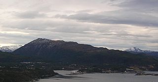
Bremsnes is a former municipality in Møre og Romsdal county, Norway. The municipality of Bremsnes was based in the village of Bremsnes, where Bremsnes Church is located. Bremsnes municipality surrounded the Bremsnesfjorden and it included parts of the islands of Averøya, Frei, and Nordlandet. Bremsnes essentially encircled the city of Kristiansund on the west, south, and east sides.

Kornstad is a village in Møre og Romsdal county, Norway. The village is located in the present-day Averøy Municipality, on the west side of the island of Averøya, along the Kornstadfjorden. Kornstad Church is located in this village. The village of Visnes lies directly across the fjord from Kornstad village.
Kvernes is a village in Møre og Romsdal county, Norway. The village of Kvernes is located in the present-day Averøy Municipality on the east coast of the island of Averøya, along the Kvernesfjorden. There are two churches in Kvernes village: Kvernes Stave Church and the Kvernes Church. The stave church is now a museum.

The Atlantic Ocean Tunnel is an undersea tunnel that is part of Norwegian County Road 64 which connects Kristiansund Municipality to Averøy Municipality in Møre og Romsdal county, Norway. The eastern end of the tunnel is on Kirkelandet island in the town of Kristiansund and the western end of the tunnel is on the island of Averøya, just west of the village of Sveggen. The 5,727-metre (18,789 ft) long tunnel runs beneath the Bremsnesfjorden, reaching a depth of 250 metres (820 ft), making it one of the deepest undersea tunnels in the world. Construction began in 2006, and the tunnel opened on 19 December 2009, later than initially estimated. Breakthrough was in March 2009. Problems with water leaks caused delays and cost overruns.
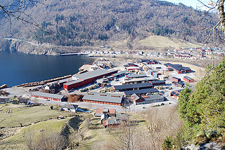
Bruhagen is the administrative center of Averøy Municipality in Møre og Romsdal county, Norway. The village is located on the east side of the island of Averøya, about midway between the villages of Bremsnes and Kvernes. Norwegian County Road 64 runs through the village.
Langøy or Langøyneset is a village in Averøy Municipality in Møre og Romsdal county, Norway. It is located on the northern part of the island of Averøya. It is located mainly on the small island of Langøya, off the northern coast of the main island of Averøya. The village is west of the village of Bremsnes and northeast of the village of Kårvåg. The Langøy Chapel is located here. The 0.65-square-kilometre (160-acre) village has a population (2012) of 359, which gives the village a population density of 552 inhabitants per square kilometre (1,430/sq mi). The Hestskjær Lighthouse lies about 2 kilometres (1.2 mi) north of this village.
Kårvåg is a village in Averøy Municipality in Møre og Romsdal county, Norway. It is located on the west side of the island of Averøya near the east end of the Atlanterhavsveien. The village of Kornstad lies to the south and the village of Langøyneset is to the north. The 0.32-square-kilometre (79-acre) village has a population (2013) of 288, which gives the village a population density of 900 inhabitants per square kilometre (2,300/sq mi).
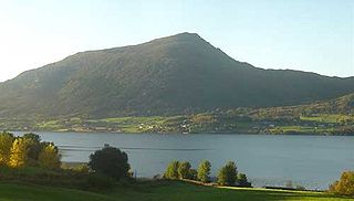
Frei is an island in Kristiansund Municipality in Møre og Romsdal county, Norway. The 62.5-square-kilometre (24.1 sq mi) island lies south of the town of Kristiansund in the Nordmøre region of the county. The main villages on the island include Rensvik in the north, Kvalvåg in the east, and Nedre Frei in the south. The island was part of the old Frei Municipality from 1838 until 2008 when the island was merged into Kristiansund Municipality.

Bremsnes Church is a parish church in Averøy Municipality in Møre og Romsdal county, Norway. It is located in the village of Bremsnes on the eastern coast of the island of Averøya, just west of the city of Kristiansund. The church is part of the Bremsnes parish in the Ytre Nordmøre deanery in the Diocese of Møre. The white wooden church is a cruciform church that was built in 1771. The church seats about 350 people.
Granvin, also known as Eide, is the administrative centre of Granvin municipality in Hordaland county, Norway. The village is located at the head of the Granvin Fjord in the central part of the municipality. The large village of Vossevangen lies about 25 kilometres (16 mi) to the northwest and the village of Ulvik lies about 20 kilometres (12 mi) to the northeast. The 0.71-square-kilometre (180-acre) village has a population (2013) of 426, giving the village a population density of 600 inhabitants per square kilometre (1,600/sq mi).

Jondal is the administrative centre of Jondal municipality in Hordaland county, Norway. The village is located on the southern shore of the Hardangerfjorden, about 55 kilometres (34 mi) southeast of the city of Bergen. It is located on the Folgefonna peninsula, about 12 kilometres (7.5 mi) northwest of the Folgefonna glacier in Folgefonna National Park. The village of Kysnesstranda lies about 15 kilometres (9.3 mi) to the south. The 0.59-square-kilometre (150-acre) village has a population (2013) of 379, giving the village a population density of 642 inhabitants per square kilometre (1,660/sq mi).

Sunde is a village in Kvinnherad municipality in Hordaland county, Norway. The village is located along the Hardangerfjorden, just north of the island of Halsnøya. The northern entrance to the Halsnøy Tunnel is located in Sunde. The large urban village of Husnes lies just to the north of Sunde, on the other end of the lake Onarheimsvatnet.