

Bretford is a hamlet in the Borough of Rugby, Warwickshire, England. It is part of the civil parish of Brandon and Bretford.
Bretford is a hamlet in the Borough of Rugby, Warwickshire, England. It is part of the civil parish of Brandon and Bretford.
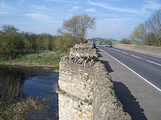
It is situated about 5 miles (8 km) west of Rugby and 7.5 miles (12.1 km) east-southeast of Coventry, at a junction of the A428 road (Coventry–Rugby) and the old Fosse Way. The two roads converge temporarily at Bretford, where they cross the River Avon on a five-arched, stone bridge just south of the village. The bridge is a Grade II listed building. [1] It is too narrow for two-way traffic and is controlled by traffic lights.
The name of the village, first recorded about 1100, is derived from the Old English bred ford, meaning "the plank ford". The reference is probably to a plank footbridge or post marking the ford across the River Avon, which preceded the bridge. [2] The original Roman line of the Fosse Way was diverted to the west in the Middle Ages to its present crossing point. The first record of the bridge is from 1279. It was said to have suffered damage during the English Civil War after which it was extensively repaired in 1653. The bridge was largely rebuilt in the 18th century to the original medieval design. [3]
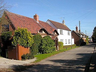
In the Middle Ages Bretford was considerably more important than it is now; it was founded as a planned market town in 1227 by the Lord of the Manor, John de Verdon. It was also the site of a leper hospital. Following the Black Death in the 14th century, Bretford fell into decline and never recovered. The hamlet now consists of around twenty houses, a pub called the Queen's Head, a farm, a small village hall, and the bridge across the Avon. [4]
During the Second World War a lighting decoy site was established around 1km north-west of Bretford, designed to trick German bombers into dropping their bombs harmlessly onto fields at the wrong location, instead of on their intended target of nearby Coventry. [5]

The Oxford Canal is a 78-mile (126 km) narrowboat canal in central England linking the City of Oxford with the Coventry Canal at Hawkesbury via Banbury and Rugby. Completed in 1790, it connects to the River Thames at Oxford, and links with the Grand Union Canal, which it is combined with for 5 miles (8 km) between to the villages of Braunston and Napton-on-the-Hill.

Rugby is a market town in eastern Warwickshire, England, close to the River Avon. At the 2021 census its population was 78,125, making it the second-largest town in Warwickshire. It is the main settlement within the larger Borough of Rugby, which had a population of 114,400 in 2021.

The Fosse Way was a Roman road built in Britain during the first and second centuries AD that linked Isca Dumnoniorum (Exeter) in the southwest and Lindum Colonia (Lincoln) to the northeast, via Lindinis (Ilchester), Aquae Sulis (Bath), Corinium (Cirencester), and Ratae Corieltauvorum (Leicester).

Southam is a market town and civil parish in the Stratford-on-Avon district of Warwickshire, England. Southam is situated on the River Stowe, which flows from Napton-on-the-Hill and joins Warwickshire's River Itchen at Stoneythorpe, just outside the town.

The A46 is a major A road in England. It starts east of Bath, Somerset and ends in Cleethorpes, Lincolnshire, but it does not form a continuous route. Large portions of the old road have been lost, bypassed, or replaced by motorway development. Between Leicester and Lincoln the road follows the course of the Roman Fosse Way, but between Bath and Leicester, two cities also linked by the Fosse Way, it follows a more westerly course.

Warwickshire is a county in the West Midlands region of England. The county town is Warwick, and the largest town is Nuneaton. The county is famous for being the birthplace of William Shakespeare at Stratford-upon-Avon and Victorian novelist George Eliot,, at Nuneaton. Other significant towns include Rugby, Leamington Spa, Bedworth, Kenilworth and Atherstone. The county offers a mix of historic towns and large rural areas. It is a popular destination for international and domestic tourists to explore both medieval and more recent history.
The A45 is a major road in England. It runs east from Birmingham past the National Exhibition Centre and the M42, then bypasses Coventry and Rugby, where it briefly merges with the M45 until it continues to Daventry. It then heads to Northampton and Wellingborough before running north of Rushden and Higham Ferrers and terminating at its junction with the A14 in Thrapston.

Bidford-on-Avon is a large village and civil parish in the English county of Warwickshire, very close to the border with Worcestershire. In the 2001 census it had a population of 4,830, increasing to 5,350 at the 2011 census.

Wolston is a village and civil parish in the Rugby borough of Warwickshire, England. The village is located roughly halfway between Rugby and Coventry, and had a population of 2,692 at the 2021 census. It is close to the A45 road and the Roman road the Fosse Way.
The A428 road is a major road in central and eastern England. It runs between the cities of Coventry and Cambridge by way of the county towns of Northampton and Bedford. Together with the A421,, the eastern section of the A428 forms the route between Cambridge and Oxford. The A428 was formerly part of the main route from Birmingham to Felixstowe before the A14 was fully opened in 1993.

Brandon is a small village in Warwickshire, England. Along with nearby Bretford, it forms part of a joint civil parish of Brandon and Bretford. Administratively it is part of the borough of Rugby. The River Avon passes just to the east of the village. Brandon is located upon the A428 road between Coventry, 5 miles (8.0 km) to the west, and Rugby, 6 miles (9.7 km) to the east. 1 mile (1.6 km) west of Brandon is the suburban village of Binley Woods and 1.5 miles (2.4 km) to the east is the small hamlet of Bretford.
Brandon and Bretford is a civil parish in the Rugby borough of Warwickshire, England. It contains the village of Brandon and the smaller hamlet of Bretford. Both are within 1½ miles of each other, along the A428 road. In the 2001 Census the parish had a population of 588, increasing to 643 at the 2011 Census, and again to 675 at the 2021 census.
Offchurch is a village and civil parish on the River Leam, 3 miles (4.8 km) east of Leamington Spa in Warwickshire. The population of the civil parish at the 2011 census was 250.

The Coventry Way is a 40-mile (64 km) long distance footpath in central England that starts and finishes in Meriden. It forms a circular route around the city of Coventry covering countryside in both the West Midlands and Warwickshire. The path is managed by A Coventry Way Association.
Whitchurch is a parish and a small hamlet lying on the left bank of the River Stour in Warwickshire, England, some four miles south-south-east of the town of Stratford-upon-Avon.
Little Lawford is a hamlet and civil parish around 0.6 miles (0.97 km) to the north of the much larger village of Long Lawford and west of Rugby in Warwickshire, England. Consisting of 5 dwellings plus numerous other buildings that are used for commercial or farming business, in 2001 the parish had a population of 12 people. In the 2011 Census the population details were recorded under Long Lawford.
Church Lawford is a village and civil parish in Warwickshire. It is located just under 2.5 miles (4 km) west of the town of Rugby and 4.5 miles (7 km) east of Coventry. The population of the civil parish taken at the 2021 census was 432.

Great Wolford is a village and civil parish in the Stratford-on-Avon district of Warwickshire, England. With the neighbouring parish of Little Wolford it is part of 'The Wolfords'.

The River Swift is a 14-mile (23 km) long tributary of the River Avon that rises in south Leicestershire, and flows through the town of Lutterworth before joining the Avon at its confluence at Rugby in Warwickshire in the English Midlands.

Brandon Viaduct is a railway viaduct crossing the River Avon between the villages of Brandon and Wolston in Warwickshire. It carries the Birmingham Loop line and is roughly half way between Rugby and Coventry. The bridge was built in around 1835 for the London and Birmingham Railway and is now a grade II listed building.
Coordinates: 52°23′28″N1°22′12″W / 52.391°N 1.370°W
| | This Warwickshire location article is a stub. You can help Wikipedia by expanding it. |