
Central Suffolk and North Ipswich is a constituency represented in the House of Commons of the UK Parliament since 2010 by Dan Poulter, who was elected as a Conservative but announced his defection to Labour in April 2024.

Suffolk County Council is the administrative authority for the county of Suffolk, England. It is run by 75 elected county councillors representing 63 divisions. It is a member of the East of England Local Government Association.

Gainsborough is an area of Ipswich, in the Ipswich district, in the county of Suffolk, England. It was named after the artist Thomas Gainsborough of Sudbury, who lived in Ipswich for several years. He was noted for visiting the banks of the Orwell in this area.
Pinewood is a civil parish and electoral ward in the Babergh district of the English county of Suffolk. Whilst not part of the borough, it forms part of the town of Ipswich although part of the parish is separated from it by Belstead Brook, a tributary of the River Orwell. The parish was formed on 1 April 1994 from parts of Washbrook, Belstead and Wherstead. It is in the Belstead Brook electoral division of Suffolk County Council. In 2011 it had a population of 4342.

Elections to Suffolk County Council were held on 5 May 2005. The whole council was up for election with boundary changes since the last election in 2001 reducing the number of seats by 5. The Conservative Party gained control of the council from no overall control.

Burstall is a village and civil parish in Suffolk, England. Located around 4 miles (6 km) west of Ipswich, it is part of Babergh district. The parish includes the hamlet of Burstallhill. Recorded in the Domesday Book as Burgestala / Burghestala. It is in the Belstead Brook electoral division of Suffolk County Council.

Elections to Suffolk County Council were held on 4 June 2009 as part of the 2009 United Kingdom local elections on the same day as the elections to the European Parliament. 75 councillors were elected from 63 electoral divisions, which returned either one or two county councillors each by first-past-the-post voting for a four-year term of office. The electoral divisions were the same as those used at the previous election in 2005.

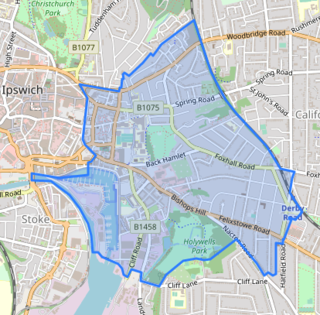
Ipswich Borough Council is the local authority for Ipswich, a non-metropolitan district with borough status in Suffolk, England. It is the second tier of a two-tier system, fulfilling functions such as refuse collection, housing and planning, with Suffolk County Council providing county council services such as transport, education and social services.

Gainsborough Division is an electoral division of Suffolk which returns one county councillor to Suffolk County Council.

Priory Heath Division is an electoral division of Suffolk which returns one county councillor to Suffolk County Council.
St Helen's Division is an electoral division of Suffolk which returns one county councillor to Suffolk County Council.

Carlford Division is an electoral division of Suffolk which returns one county councillor to Suffolk County Council.
Rushmere Division is an electoral division of Suffolk which returns one county councillor to Suffolk County Council.

Bixley Division is an electoral division of Suffolk which returns one county councillor to Suffolk County Council.
St John's Division is an electoral division of Suffolk which returns one county councillor to Suffolk County Council. It is located in the North East Area of Ipswich and consists of most of St John's Ward and part of Alexandra Ward of Ipswich Borough Council.
Chantry Division is an electoral division of Suffolk which returns two county councillors to Suffolk County Council.
St Margaret's and Westgate Division is an electoral division of Suffolk which returns two county councillors to Suffolk County Council.
Whitehouse and Whitton Division is an electoral division of Suffolk which returns two county councillors to Suffolk County Council.
The 1979 Ipswich Borough Council election was the first election to the Ipswich Borough Council under the new arrangements determined by the Local Government Boundary Commission as laid out in their Report 280. In accordance with the Local Government Act 1972 the Council had request a system of electing by thirds. Originally the Council had argued for 18 wards with 3 councillors each, making 54 in total. However, when this was analysed in terms of the Suffolk County Council (SCC), this was more numerous than would be compatible with the SCC's desired size of 75 members. The Ipswich Borough Council was invited to submit a revised proposal, leading to the creation of 16 wards with 3 councillors each. This became the finalised structure of the wards for the 1979 election.