
Boothstown is a suburban village in the City of Salford in Greater Manchester, England. Boothstown forms part of the Boothstown and Ellenbrook ward, which had a population at the 2011 Census of 9,599. The village is within the boundaries of the historic county of Lancashire, west of the City of Salford, bordered to the north by the East Lancashire Road A580 and to the south by the Bridgewater Canal. Historically, it was a hamlet partly in Worsley township in the parish of Eccles, and partly in Tyldesley in the parish of Leigh.

Astley is a village in the Metropolitan Borough of Wigan, Greater Manchester, England. Within the boundaries of the historic county of Lancashire, it is crossed by the Bridgewater Canal and the A580 East Lancashire Road. Continuous with Tyldesley, it is equidistant from Wigan and Manchester, both 8.3 miles (13.4 km) away. Astley Mosley Common ward had a population of 11,270 at the 2011 Census.

Walkden is a town in the City of Salford in Greater Manchester, England, six miles northwest of Salford, and seven miles of Manchester.

Ellenbrook is a suburb of Worsley, in the City of Salford in Greater Manchester, England. Ellenbrook is 6.8 miles (10.9 km) west of Manchester, 5 miles (8.0 km) west of Salford and 4.6 miles (7.4 km) south of Bolton. Historically a part of Lancashire, it is close to Astley, Mosley Common and Walkden, by the East Lancashire Road.

Mosley Common is a suburb of Tyldesley at the far-eastern edge of the Metropolitan Borough of Wigan, in Greater Manchester, England. Historically part of Lancashire, it was anciently a hamlet in the east of the township of Tyldesley cum Shakerley, in the ancient parish of Leigh. The area of Mosley Common in 1747 was 34 acres (14 ha) statute s.

The Lancashire Coalfield in North West England was an important British coalfield. Its coal seams were formed from the vegetation of tropical swampy forests in the Carboniferous period over 300 million years ago.
The Astley and Tyldesley Collieries Company formed in 1900 owned coal mines on the Lancashire Coalfield south of the railway in Astley and Tyldesley, then in the historic county of Lancashire, England. The company became part of Manchester Collieries in 1929 and some of its collieries were nationalised in 1947.
Tyldesley Coal Company was a coal mining company formed in 1870 in Tyldesley, on the Manchester Coalfield in the historic county of Lancashire, England that had its origins in Yew Tree Colliery, the location for a mining disaster that killed 25 men and boys in 1858.
Ramsden's Shakerley Collieries was a coal mining company operating the Nelson and Wellington Pits from the mid 19th century in Shakerley, Tyldesley in the historic county of Lancashire, England.
Bedford Colliery, also known as Wood End Pit, was a coal mine on the Manchester Coalfield in Bedford, Leigh, Lancashire, England. The colliery was owned by John Speakman, who started sinking two shafts on land at Wood End Farm in the northeast part of Bedford, south of the London and North Western Railway's Tyldesley Loopline in about 1874. Speakman's father owned Priestners, Bankfield, and Broadoak collieries in Westleigh. Bedford Colliery remained in the possession of the Speakman family until it was amalgamated with Manchester Collieries in 1929.
Manchester Collieries was a coal mining company with headquarters in Walkden formed from a group of independent companies operating on the Manchester Coalfield in 1929. The Mining Industry Act of 1926 attempted to stem the post-war decline in coal mining and encourage independent companies to merge in order to modernise and better survive the economic conditions of the day. Robert Burrows of the Atherton company Fletcher Burrows proposed a merger of several independent companies operating to the west of Manchester. The merger was agreed and took place in March 1929.
Fletcher, Burrows and Company was a coal mining company that owned collieries and cotton mills in Atherton, Greater Manchester, England. Gibfield, Howe Bridge and Chanters collieries exploited the coal mines (seams) of the middle coal measures in the Manchester Coalfield. The Fletchers built company housing at Hindsford and a model village at Howe Bridge which included pithead baths and a social club for its workers. The company became part of Manchester Collieries in 1929. The collieries were nationalised in 1947 becoming part of the National Coal Board.
New Manchester or The City was an isolated mining community on the Manchester Coalfield north of Mosley Common in the Tyldesley township, England. It lies west of a boundary stone at Ellenbrook which marks the ancient boundary of the Hundreds of Salford and West Derby, the boundary of Eccles and Leigh ecclesiastical parishes, Tyldesley, Worsley and Little Hulton townships and the metropolitan districts of Wigan and Salford. The route of the Roman road from Manchester to Wigan and the Tyldesley Loopline passed south of the village. The Lancashire and Yorkshire Railway's Manchester to Southport line passed to the north.

Astley Green Colliery was a coal mine in Astley, Greater Manchester, then in the historic county of Lancashire, England. It was the last colliery to be sunk in Astley. Sinking commenced in 1908 by the Pilkington Colliery Company, a subsidiary of the Clifton and Kersley Coal Company, at the southern edge of the Manchester Coalfield, working the Middle Coal Measures where they dipped under the Permian age rocks under Chat Moss. The colliery was north of the Bridgewater Canal. In 1929 it became part of Manchester Collieries, and in 1947 was nationalised and integrated into the National Coal Board. It closed in 1970, and is now Astley Green Colliery Museum.
Gin Pit was a coal mine operating on the Lancashire Coalfield from the 1840s in Tyldesley, Greater Manchester then in the historic county of Lancashire, England. It exploited the Middle Coal Measures of the Manchester Coalfield and was situated to the south of the Tyldesley Loopline.
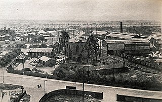
Mosley Common Colliery was a coal mine originally owned by the Bridgewater Trustees operating on the Manchester Coalfield after 1866 in Mosley Common, Greater Manchester, then in the historic county of Lancashire, England. The colliery eventually had five shafts and became the largest colliery on the Lancashire Coalfield with access to around 270 million tons of coal under the Permian rocks to the south.
Linnyshaw Colliery or Berryfield was a coal mine originally owned by the Bridgewater Trustees operating after 1860 on the Manchester Coalfield in Walkden, Greater Manchester, then in the historic county of Lancashire, England.
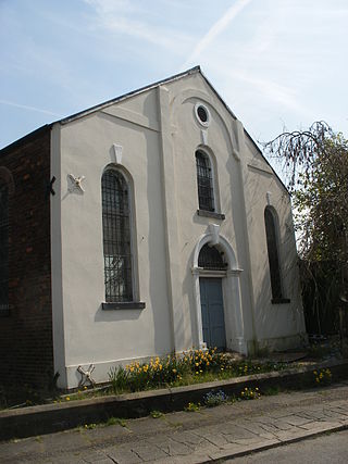
Chaddock Hall was an ancient hall on Chaddock Lane in Tyldesley, Greater Manchester, England. It was designated a Grade II listed building in 1966. It was gutted in an arson attack in 2014.
Ellesmere Colliery was a coal mine in Walkden, Manchester, England. The pit was located on Manchester Road, a short distance south of Walkden town centre.
